
Hike time: | 3-7 hours |
Start: | Wengen |
Finish: | Wengen |
Season: | Summer |
Profile: | between 1270m and 2060m, with several options |
Rating: | very easy paths or medium options |
Wengen is a picturesque and popular resort in the heart of the Berner Oberland. It is perched up on a ledge, almost 500m above the valley floor below, but still a long way below the mountains which form the backdrop.
This hike takes the footpath uphill from Wengen, which roughly follows the course of the railway track as far as Wengernalp. You can then continue all the way up to Kleine Scheidegg, with its views over the other side to Grindelwald, before looping back down to Wengen. You can also loop back a different way from Wengernalp, with a choice of paths. The views of the Jungfrau and the Lauterbrunnen valley are stunning.
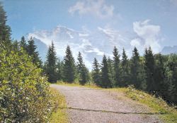 The path leading up from Wengen 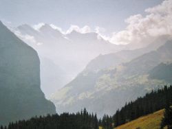 View back down towards Lauterbrunnen 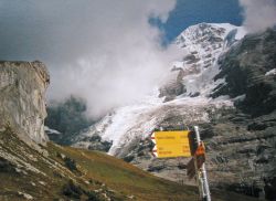 Towering scenery near Haaregg 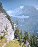 Hikers dwarfed by the massive cliffs |
Wengen is reached with a short cog train up from Lauterbrunnen, which is itself reached by train from Interlaken Ost.
From Zürich, this is best done as a weekend trip, via Bern, perhaps combined with another hike such as Under the Eiger.
Hotel accommodation in Wengen is plentiful, but budget accommodation is somewhat difficult to find. Chilis used to have a hostel, but no longer offer any accommodation, and the Jungfraublick and Alpenblick have also stopped offering hostel-style rooms. Ask at the tourist information centre on the main street in Wengen, and phone up from the free phone board at the station. I can recommend the Hotel Bernerhof, which is reasonably priced, centrally located and offers rooms of a variety of standards, even the cheapest of which are clean and pleasant.
For a zoomable, scrollable map of this hike, see this online map using Openstreetmap or Opencyclemap.
You can also download this kmz file wengen.kmz to open it in programs like Google Earth or GpsPrune and then transfer the track to your GPS.
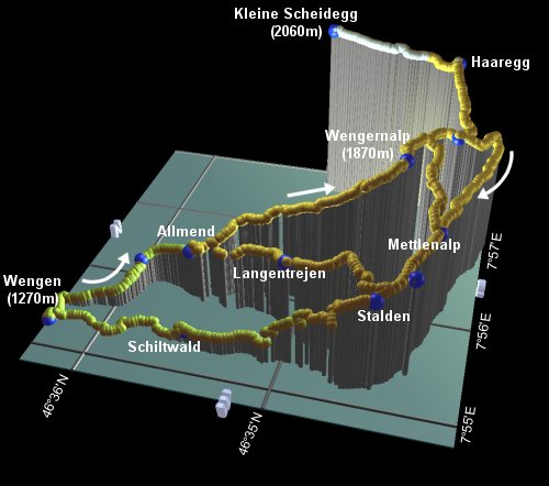
Wengen - Allmend - Wengernalp - Haaregg - Mettlenalp - Allmend - Wengen
 |
First, if you haven't done so already, then take some time to admire the views from Wengen itself, either from the village or from the viewpoint at the railway station. The Jungfrau far above, the Lauterbrunnen valley far below, with its textbook sheer glacial walls, it's quite something.
From the railway station, follow the path up the left-hand side of the railway tracks, climbing gently up through the village. At the Hotel Eden, turn right underneath the railway line and follow the paved path between the idyllic houses and gardens to reach In Gassen after around 20 minutes. The craggy wall of the Tschuggen ridge imposes itself right above you at this point.
From here, the paved path becomes a good track, and rises steeply through the woods, although still not very far from the train line. After passing the restaurant Allmend, follow the path up to the left, passing underneath the railway and continuing up the left-hand side to reach a picnic lookout after around 40 minutes.
Continuing to climb, the path turns a corner and directly faces the Jungfrau, the pristine Silberhorn peak and the tumbling glacier appearing suddenly from behind the ridge. A little farther up is a lookout point off to the right, from where there are good views back towards Wengen and the valley, as well as up towards the Jungfrau and Mönch. From this lookout point, the crowds grow substantially, until you reach Wengernalp station at around 30 minutes.
Once at Wengernalp station, you have the choice of continuing up alongside the railway up to Kleine Scheidegg, or the signposted path up to Haaregg, or a couple of routes down to Mettlenalp. The trip up to Kleine Scheidegg is recommended (despite the crowds) and you can easily return a different way (or by train). One easy route down from Wengernalp, signposted Mettlenalp, descends gently towards the two chairlift stations at Wixi, where you may spot (and hear) rumbling snowfalls on the mountain flanks opposite. It then continues round to the right, signposted to Mettlenalp, joining the slightly longer path coming down from Haaregg and Weissefluh.
The path carries on through fields of cows (for some reason the cows here sound like Chewbacca), with yet another great and precipitous viewpoint with benches off to the left across the field. Shortly you get another choice, with the main track continuing down to Langentrejen and emerging back at the restaurant Allmend, which you passed on the outbound route. The alternative, longer, route follows the signposts left to Stalden, giving amazing clifftop views from Staldenflüh of the Lauterbrunnen valley, the path seemingly suspended miles up. It then sweeps back round towards Wengen, showing the whole Lauterbrunnen valley with its waterfalls, before entering Wengen on a narrow road.
As can be seen from the plot, there are several variations possible here, of various lengths.
You could also use the train to turn this into a one-way walk, either uphill or downhill. For more options, see the leaflet mentioned
in 'More info' below.
The following are the coordinates for waypoints along this route, obtained from GPS. They can be used either in another GPS, or along with a map, to provide additional references if necessary.
                           Latitude       Longitude    Altitude(m)
Wengen Station            N 46°36'17.5    E007°55'15.4    1274
In Gassen                 N 46°35'54.7    E007°55'51.9    1399
Allmend restaurant        N 46°35'37.0    E007°55'51.7    1482
Wengernalp                N 46°34'32.2    E007°56'20.7    1871
Kleine Scheidegg          N 46°35'07.3    E007°57'41.1    2061
Haaregg                   N 46°34'22.9    E007°57'35.8    1990
Weissefluh                N 46°34'18.7    E007°56'54.9    1835
Mettlenalp                N 46°34'18.7    E007°55'54.7    1725
Schiltwald                N 46°35'31.9    E007°55'20.1    1310
Langentrejen              N 46°35'02.2    E007°55'37.7    1600
Lookout                   N 46°34'22.6    E007°55'25.0    1700
Stalden                   N 46°34'32.1    E007°55'12.4    1665
The main tourism site for the area is wengen-muerren.ch, giving hiking suggestions, small maps and accommodation information. Invaluable however, is the free leaflet available from almost any station in the area, called "Wandern Jungfraubahnen", giving an excellently clear panoramic map with all the trains, lifts and hikes marked, together with multilingual hike suggestions.
Online maps are also available at jungfraubahn.ch (under English-Jungfrau Region-maps). Also, for more hikes in the area, see Under the Eiger and Over the Faulhorn, or a complete crossing of the Kleine Scheidegg is described as part of the Alpine Pass Route.