
Hike time: | 6 hours |
Approx dist: | 25 km |
Start: | Hoch-Ybrig Chli Sternen |
Finish: | Mostelberg |
Season: | Summer |
Profile: | from 1820m down to 1200m with several dips |
Rating: | easy but quite long |
Greetings: | "Gruezi", "Gruezi mitenand" |
This hike follows the Schwyzer Panoramaweg through central Switzerland, and as the name suggests, the scenery is truly fantastic. The well-prepared and easy trail leads along fairly high ridges, before traversing round the base of the impressive Mythens. The route starts at a fairly high altitude and descends for most of the way, although the climbs to Rotenfluh and Haggenegg are certainly noticeable. There is an option to take a dramatic side trip up to the top of the Grosser Mythen, for amazing views.
The signposting is absolutely flawless, making it almost impossible to get lost, and a variety of shorter walks can be arranged using any of the numerous chairlifts and cable cars in the area.
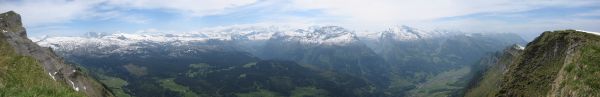 Panoramic view South from near Sternen 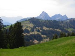 View towards the Grosser Mythen, in the centre 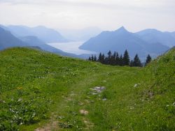 Path heading towards Rigi and the Vierwaldstättersee |
The base station of Hoch-Ybrig at Weglosen is reached (as in the Winter) by post bus from Einsiedeln. From there the cable car can take you up to Seebli, and from there a chairlift can also take you up to Kleine Sternen for the start of the Panoramaweg. Beware that all the Hoch-Ybrig lifts are closed until July (check their website link below), adding a hefty climb from Weglosen (1035m) up to the ridgetop. There are also paths up from Seebli if you prefer not to take the chairlift. Or get the bus from Schwyz to Ibergeregg to miss out the first bit of the walk.
At the end of the hike in Mostelberg, there is a chairlift down to Sattel-Aegeri, from where there are trains to Arth-Goldau and Biberbrugg. Or a slightly shorter, but steeply descending, path leads down from Zwütschet Mythen to Schwyz, giving connections to Schwyz rail station.
From Zurich this is an easy day trip, with a train to Wädenswil, a connecting train to Einsiedeln, and the connecting postbus to Weglosen. On the way back, there are a few options, usually changing either at Arth-Goldau, or at Biberbrugg and Wädenswil. The train ticket costs CHF20 with halbtax, and then you have to add the Hoch-Ybrig cable car (CHF10) and the Mostelberg chairlift (CHF6 with halbtax).
Closing times again cause problems here, note that the last chairlift from Mostelberg is at 17:30, or if you're taking the hike in the opposite direction, the last bus from Weglosen is at 17:20.
For a zoomable, scrollable map of this hike, see this online map using Openstreetmap or Opencyclemap.
You can also download this kmz file mythens.kmz to open it in programs like Google Earth or GpsPrune and then transfer the track to your GPS.
Chli Sternen - Spirstock - Ibergeregg - Rotenfluh - Holzegg - Haggenegg - Mostelberg
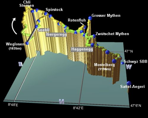 |
Depending on your energy, enthusiasm, and diligence in checking the cable car schedules, you may have an uphill hike to get to the Panoramaweg. From Weglosen it takes around 50 minutes to reach Spirstock, or if you're really keen you can climb from Weglosen up to Chli Sternen. The ridgetop East of Chli Sternen is a somewhat exciting blue-white ridgetop route, which is very exposed.
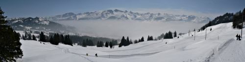
Having reached the panoramaweg, by whatever means, the scenery on the other side of the ridge is well worth a gasp or two. The ridge is extremely steep, and the snow-covered peaks loom impressively beyond to the South From here, the navigation is simple, as every signpost marks the 'Panoramaweg'. Follow them, and climb up the wooden steps for about 15 minutes to reach Spirstock, with its restaurant and viewpoint at the highest point of this hike. The spectacular views from this lookout are only slightly marred by the noisy chairlift just metres away (if it's running).
From the restaurant, follow the path under the chairlift cables and through Laucheren-Chappel to Windegg (after 20 minutes), where the views open out towards the Mythens. Continue dropping down the rough track through Sternenegg to Ober Altberg, before crossing a road and weaving along a narrow woodland trail. This shortly emerges back on the same road at Ibergeregg, where the road crosses over the pass. Another restaurant lies here, around 1h30m from Windegg. This is a busy pass, very popular with cyclists and motorcyclists, and provides an alternative start/finish point for the walk.
Another 45 minutes or so takes you through Müsliegg and up to Rotenfluh, where near the top of the cable car there is a popular paraglider take-off area. There's also a couple more restaurants, and a little further up a hang-glider ramp offering (yet more) great views. If you wish, you can avoid the climb up to Rotenfluh by following the signs to the Grosser and Kleiner Mythen instead of Rotenfluh. This path goes round the right-hand side of the Rotenfluh peak, and rejoins the Panoramaweg by Holzegg.
From Rotenfluh, the path climbs further, and then drops down a steep stony track to Holzegg after around 30 minutes. Here there are yet more restaurants as well as a cable car down to Brunni. It is from here that the optional side trip to the top of the Grosser Mythen begins.
The path up the Grosser Mythen is one only for the keen. It's rather steep, it's rocky and narrow, and care is required placing one's feet. Signs have been placed warning walkers to take care, and not rush, so it's not recommended for the timid. The handrails and walkways make it quite safe though, and the exposed narrow path is quite something to experience. As, of course, are the amazing views from the top. It's an ideal vantage point for central Switzerland, with numerous lakes, peaks, valleys and towns all on show. And, amazingly enough, there's even a small cafe on the top, serving drinks and snacks to the deserving hikers.
From Holzegg the path climbs just under 400m, taking around 1h20 upwards and around 1 hour back down to Holzegg.
From Holzegg, our path heads straight to the base of the Mythens, and still following the 'panoramaweg' signs, skirts round the right-hand side of the Grosser Mythen as it looms above. For those wishing to hike down to Schwyz, the route splits here, following the signs to the left and up to Zwütschet Mythen, a gap between the Grosser and Kleiner Mythens. After admiring the views, follow the steep path descending down towards Schwyz (the signs only show a bus symbol, since the train station is a further 20 minutes' walk past there to Seewen).
For those continuing past the Mythens on the Panoramaweg, the views temporarily disappear as the route winds through forest, before emerging onto a road just above Haggenegg (about 1 hour from Holzegg). Follow the paved road down through the tiny village of Haggenegg, forking right onto a level path across the fields. After around half an hour, this drops down into Mostelegg, with Rigi and the Zugersee off to your left. Another hour brings you through Engelstockweid to Mostelberg, and the end of this hike.
From Mostelberg, the chairlift (CHF6 with halbtax) takes you down to Sattel, from which Sattel-Aegeri station is a 10-minute signposted walk away. Alas, the last chairlift from Mostelberg is currently at 17:30, so if you miss that, you're left with an easy, but fairly steep, walk down underneath the chairlift cables, adding around 30-40 minutes.
 |
This makes a fairly long walk in one go, so you may wish to take advantage of the many transport connections on the way, for example Ibergeregg, Holzegg or Rotenfluh. Some of the best panoramic views can be had on the stretch between Spirstock and Rotenfluh. The opposite direction is also quite possible, although obviously involving more climbing, but find out the closing times of the transport back (especially from Weglosen).
A winter variation makes a much shorter loop from Holzegg round to Ibergeregg and back - see "Holzegg in the Winter" under
other walks.
                       Latitude       Longitude    Altitude(m)
Weglosen              N 47°01'12.7    E008°48'30.2      1035
Stäfel rest.          N 47°00'14.6    E008°47'15.9      1558
Sternen chairlift     N 46°59'59.8    E008°47'52.4      1820
Wildä Maa             N 46°59'48.8    E008°47'26.8      1826
Spirstock             N 47°00'05.3    E008°46'21.6      1761
Windegg               N 47°00'16.1    E008°45'49.7      1715
Sternenegg            N 47°00'20.2    E008°44'54.1      1497
Ober Altberg          N 47°00'32.5    E008°44'10.9      1433
Ibergeregg            N 47°01'03.4    E008°44'00.7      1406
Zwäcken               N 47°01'26.8    E008°43'11.5      1453
Müsliegg              N 47°01'23.3    E008°42'55.1      1427
Rotenfluh             N 47°01'04.7    E008°42'01.9      1526
Stäglerenegg          N 47°01'31.9    E008°42'15.7      1463
Holzegg               N 47°01'43.5    E008°41'56.9      1408
Grosser Mythen        N 47°01'47.6    E008°41'19.7      1899
Zwütschet Mythen      N 47°02'02.0    E008°40'58.8      1438
Günterigs             N 47°01'53.0    E008°40'42.4      1124
Chlösterli            N 47°01'23.9    E008°39'40.5       571
Schwyz bus stn        N 47°01'16.4    E008°39'04.7       547
Schwyz train stn      N 47°01'35.6    E008°37'56.5       487
Haggenegg             N 47°03'06.4    E008°41'01.2      1410
Mostelegg             N 47°03'19.1    E008°39'36.9      1264
Engelstockweid        N 47°03'32.6    E008°38'27.9      1149
Mostelberg            N 47°04'02.5    E008°39'00.2      1191
Sattel-Aegeri stn     N 47°04'47.9    E008°37'38.9       772
At hoch-ybrig.ch you can find rough plans of the hiking area as far as Spirstock, plus information on how to get there. Also at ibergeregg.ch there is a superb panoramic map of the whole hike (albeit in Winter clothes) under 'Standort Ibergeregg' and then 'Panoramakarten'. And finally there's a brief description and a profile on the schwyzer-wanderwege.ch site.
Also, if you're interested in more Wintry activities in the area, see the Activity Workshop's Snowboarding in Hoch-Ybrig and Snowboarding in Brunni pages.