
Hike time: | 3.5 hours |
Start: | Fafleralp bus stop |
Finish: | Lauchernalp cable car |
Season: | Summer |
Profile: | from 1760m up to 2100m and back down to 1960m |
Rating: | easy |
The Lötschental is a deep and picturesque valley leading East from Goppenstein, and because it is more or less a dead-end, it doesn't attract so many crowds. This walk follows the "Lötschentaler Höhenweg" along the Northern side of the valley, enjoying sweeping views along the length of the valley.
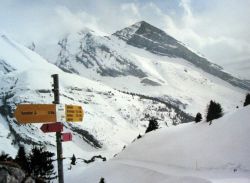
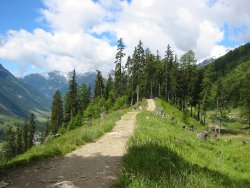 Ridgetop path near Schwarzsee 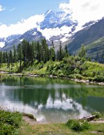 The not-very-black Schwarzsee 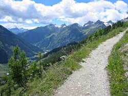 The Lötschental valley  The Lötschental valley |
An hourly bus connects Fafleralp and Wiler with Goppenstein, which is a major station on the line between Kandersteg and Brig, just South of the Lötschberg tunnel. The walk can be done in either direction, so you can choose whether to take the bus to Wiler and the cable car up to Lauchernalp, or take the bus all the way to Fafleralp and use the cable car for descent.
Kandersteg makes an excellent base for this walk, with special round-trip tickets available from the machines or from the counter. It takes around 50 minutes to Fafleralp, or about 30 minutes to the lower cable car station at Wiler.
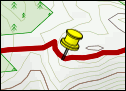
For a zoomable, scrollable map of this hike, see this online map using Openstreetmap or Opencyclemap.
You can also download this kmz file loetschental.kmz to open it in programs like Google Earth or GpsPrune and then transfer the track to your GPS.
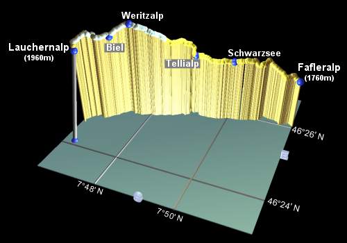 |
Fafleralp - Schwarzsee - Tellialp - Weritzalp - Biel - Lauchernalp
From the bus stop at Fafleralp, take the signposted path to the left, marked for the Höhenweg and Lauchernalp. This climbs a little away from the road, and shortly meets a track signposted to a restaurant. Taking this track round to the right will avoid an unnecessary climb on the path up to a small church and the drop back down the other side.
Continue to follow the Lauchernalp signs and the paint splashes guiding the way up the hillside and onto a clearer path. Shortly the path follows a slight ridge looking down on the valley below, just before reaching the tranquil Schwarzsee after around 1h20 from Fafleralp.
The path is now quite level, heading between the trees again, and after around 20 minutes reaches Tellialp with a small and basic refreshment stop.
Climbing fairly steeply now, follow the markings around a small inlet, resume your original Southwesterly course and after a level stretch, climb steadily up to the day's high point at Weritzalp, around 1h10 from Tellialp.
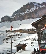
Follow the road downhill to Biel, where it levels out, and then just one more short, sharp pull brings you to the downhill path to Lauchernalp, about 45 minutes from Weritzalp. The cable car is very difficult to miss, and just next door is a rather indifferent self-service restaurant with a good terrasse.
Incidentally, this area round Lauchernalp is a ski resort in the Winter, and they are currently building a new cable car to extend the top - for such a seemingly isolated spot, they'll soon have a ski area going up to 3100m! There's quite a bit of building work going on in Lauchernalp as well, presumably in anticipation of additional demand.
The Lötschental Tourism site at loetschental.ch has some hiking suggestions
under "Wandervorschläge" and a panoramic popup map under "Panorama".
There's also a similar panoramic map in pdf format at loetschbergregion.ch
under "Sommerpanorama" and information about the Lauchernalp cable car at lauchernalp.ch.
There's also a small amount of information about the Lötschental at vs-wallis.ch.
At kandersteg.ch there is a description of a variety of walks in the area.
The following are the coordinates for waypoints along this route, obtained from GPS. They can be used either in another
GPS, or along with a map, to provide additional references if necessary.
                           Latitude       Longitude     Altitude(m)
       Fafleralp          N 46°26'04.0    E007°51'44.7     1763
       Schwarzsee         N 46°25'51.4    E007°50'05.0     1859
       Tellialp           N 46°25'46.7    E007°49'04.5     1865
       Weritzalp          N 46°25'17.5    E007°47'33.3     2099
       Biel               N 46°25'06.3    E007°47'07.0     2020
       Lauchernalp        N 46°24'40.9    E007°46'27.7     1960
       Wiler              N 46°24'06.3    E007°46'41.3     1400
The prepared trail winding up the valley
Snowy cliffs at Schwarenbach
There are a host of great walks from nearby Kandersteg, some of which are also cleared in the Winter. Among these is the walk from Sunnbüel to the Gemmi Pass, pictured with its Winter snow. If you wish, you can walk in the Summer all the way from Kandersteg over the pass to Leukerbad, as described at kandersteg.ch.
Other nearby walks include up the well-hidden and beautiful Gasterntal, with its sheer rock walls and waterfalls, or use the Allmenalp cable car to explore around to Ueschinen. The pristine Oeschinensee is also well worth a visit, although the walking there is more or less limited to fairly tricky paths up towards the Blümlisalphütte or paths back down to Kandersteg. The Alpine Pass Route passes the Oeschinensee on its way from Griesalp to Kandersteg.