
Hike time: | 6 hours |
Start: | Hörnli Express bus stop, Arosa |
Finish: | Lenzerheide post bus stop |
Season: | Summer |
Profile: | from 1810m up to 2900m, then down to 1470m |
Rating: | Quite a bit of climbing, mostly medium-tricky, but some tricky bits on the summit |
Between the valley of Arosa and that of Lenzerheide, squats the Parpaner Rothorn - at almost 2900m high, this is a serious hike. It would be nice to espouse wildly on the stupendous views available from the top, but alas thick cloud can at times envelop the optimistic hiker (such as at the time of research), reducing the panorama somewhat. But the picture boards at both the main summit (Hauptgipfel) and the slightly higher East summit (Ostgipfel) promise spectacular scenery given the right conditions.
Obviously, this hike involves quite a bit of climbing, and even more descending. Some other hazards include loose rock in places, slippy protruding tree roots in others, and sporadic signposting on the descent. But given plenty of time, this hike provides an enjoyable challenge, two lakes, and a rather high waterfall.
If you're in the area in the Winter, you won't find many hikers on this trail. But the hikers might be snowboarding in Lenzerheide or Arosa instead.
Both Arosa and Lenzerheide are easily accessible from Chur - Arosa by scenic railway (1 hour) and Lenzerheide by scenic post bus (30 mins). There's also a free(!) bus from Arosa station to the start of the walk, at the lower station of the Hörnli Express gondola lift.
From Zurich, you just need to add the time to Chur and back, which takes about 1 hour 20 each way. The ticket is just a round-trip ticket, to Arosa and from Lenzerheide, which with a halbtax card costs CHF 40.
For a zoomable, scrollable map of this hike, see this online map using Openstreetmap or Opencyclemap.
You can also download this kmz file arosa_lenzerheide.kmz to open it in programs like Google Earth or GpsPrune and then transfer the track to your GPS.
Arosa - Schwellisee - Arven - Älplisee - Parpaner Rothorn - Alp Sanaspans - Wasserfall - Lenzerheide
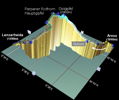 |
going Westwards from right to left |
The Hörnli Express gondola station has free panoramic hiking maps available at the counter - they only cover the Arosa side but are worth picking up before starting the hike.
The trail crosses underneath, and then follows, the gondola cables up the somewhat bleak valley - follow the signs for the Schwellisee. This doesn't look like the picture postcard Switzerland, in fact images of grazed Welsh hillsides are more likely to be conjured up by these grassy and rocky slopes. After 20 minutes you arrive at the small, lonely lake of Schwellisee.
Cross the bridge and continue up the left-hand side of the lake, following the signpost to Arven, about 15 minutes further uphill. There's a useful water fountain here for refilling those bottles.
Follow the signs to Älplisee, across the streams and up the steep path. As you approach the grassy summit, several benches have been thoughtfully provided, ideal for a breather and a sampling of the views. Shortly beyond here is the lake of Älplisee, a deep turquoise colour, and even in mid-July still flanked by snow on the steep scree slopes. Continue along and above the right-hand edge between the sheep to reach the Älplisee signpost after about 25 minutes from Arven.
Follow the red-and-white signs to the Parpaner Rothorn (not the blue-and-white ones!), following a footpath up a steep ridgeside (watching out for marmots) to eventually arrive at the ridgetop of Gredigs Fürggli after about an hour. Turn left here and walk between the fencing and the rock wall, to go through the wood-and-metal avalanche tunnels. This is a rare level stretch on this hike! But not for long, after the tunnels the trail goes up steeply once again, passing to the right of the chairlift station to reach the summit of the Parpaner Rothorn after around an hour. On the top is the cable car station for the trip down to Lenzerheide, and going round the left of the building, the restaurant and viewing terrace.
But that's not the highest point of the hike, this is only the main summit, or Hauptgipfel, of the Parpaner Rothorn. Even higher is the Ostgipfel, at the end of a worthwhile 10 minute detour. At 2899m, this was, at the time of writing, the highest of these hikes so far (recently supplanted by the 2999m Pizzo Centrale). Check out the viewing boards at both Gipfels for a guide to what you can see (clouds permitting!).
From just below the Hauptgipfel, on the way to the Ostgipfel, a signposted track leads down towards Lenzerheide, suitable for both walking and biking. Indeed, mountain biking on this stretch and down to Gredigs Fürggli appears to be very popular, and there's even a downhill race taking place here (30km, 2300m altitude difference) in August 2002. At this point the steeper walking route leaves and rejoins the wider, smoother bike track a couple of times, before reaching a signpost after about 20 minutes. Here take the left-hand track signposted Sanaspans, dropping for about an hour past a second signpost and some cows to Alp Sanaspans. There's a great Alphütte just below here, ideal for a well-earned break with hot and cold drinks, home made dairy produce, and views.
The trail continues but becomes steeper and trickier with some care required. About 25 minutes further down, following the red and white markers through the many trails, you reach the picnic spot marked as Wasserfall. The waterfall itself is easy to spot - follow the noise for a minute or two along the unmarked footpath to see it in all its glory.
The sporadic markers lead you on downhill, passing underneath some electricity cables before emerging from the highland wilderness to roads and buildings after about half an hour. From here, just follow the road downhill, it eventually leads out onto the main road in Lenzerheide, on which the post bus stop is just a few minutes along to the right.
The reverse hike would not really be recommended, given the even larger and trickier climb from the Lenzerheide side. One can avoid the descent by taking the cable car from the summit of the Parpaner Rothorn down to Lenzerheide, but then you'd miss the waterfall and the opening views of the Lenzerheide valley.
                   Latitude       Longitude    Altitude(m)
Hörnli gondola   N 46°46.363'    E009°39.573'    1840
Schwellisee      N 46°45.931'    E009°39.033'    1933
Arven            N 46°45.482'    E009°38.825'    2060
Älplisee         N 46°45.166'    E009°38.220'    2156
Gredigs Fürggli  N 46°45.333'    E009°35.966'    2617
Hauptgipfel      N 46°44.564'    E009°35.841'    2852
Ostgipfel        N 46°44.581'    E009°36.220'    2899
signpost1        N 46°44.214'    E009°35.773'    2643
signpost2        N 46°43.373'    E009°35.561'    2167
Alp Sanaspans    N 46°43.440'    E009°35.054'    2050
Wasserfall       N 46°43.599'    E009°34.604'    1840
signpost3        N 46°43.768'    E009°33.860'    1590
Lenzerheide PB   N 46°43.645'    E009°33.485'    1492
No prizes for guessing the URLs lenzerheide.ch, arosa.ch and rothorn.ch.