
Hike time: | 5.5 hours |
Start: | Niederschlagwald chairlift |
Finish: | Amden |
Season: | Summer |
Profile: | from 1290m up to the summit at 1950m, then back down to 910m |
Rating: | fairly long, mostly medium difficulty, but some loose sections near the summit can be tricky |
Greetings: | "Gruezi", "Gruezi mitenand" |
If the views of Säntis from a 1950m peak aren't sufficient incentive, this hike also provides views down the Glarus valley to the snow-topped Glarnerland peaks, and also a vertiginous peek down at the beautiful Walensee, over 600m below. This fairly long hike makes a circuit around the sheer Mattstock, exploring a less well-known but extremely rewarding area.
The peak itself, Speer, lies at the top of a steep side-trip from this circuit, with a backtrack necessary to return to Oberchäseren.
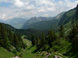 Looking back from the path up from Vordermatt 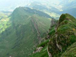 Rock strata at the peak of Speer  Amden, the Churfirstens, and the Walensee from Durschlegi. |
This is a convenient day trip from Zurich, taking the direct train to Ziegelbrücke (50 mins) and then the post bus from there to Amden Post (15 mins). Just up the road from the post bus stop at Amden is the Sesselbahn (chairlift) which takes you up to the start of the walk. The return trip is the trip back from Amden Post, from which hourly post buses leave back to Ziegelbrücke.
From Zurich, the ticket required is a return to Amden Post (CHF 24 with halbtax, available from the ticket machines) plus the chairlift ticket (CHF 8).
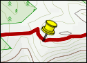
For a zoomable, scrollable map of this hike, see this online map using Openstreetmap or Opencyclemap.
You can also download this kmz file speer.kmz to open it in programs like Google Earth or GpsPrune and then transfer the track to your GPS.
Niederschlagwald - Hinter Höhi - Oberchäseren - Speer - Oberchäseren - Unterchäseren - Durschlegi - Amden
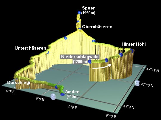 |
3D plot of the Speer hike |
Just over the road from Amden Post bus stop, there is an excellent model of the area, giving a marvellous 3d impression of the hike. Check this out before you get the chairlift up.
Once at the top of the chairlift, start the hike by bearing right, following the signs to Hinter Höhi. The wide track follows the contour of the hillside, with the Walensee below to the right and the high ridge of the Mattstock above to the left. After about 10 minutes, it reaches a cafe at Strichboden, where the signs direct you left up a paved (but empty) road. After winding up the hill, a track leaves the road off to the right, and shortly reaches the open summit of Hinter Höhi after about 20 minutes.
Follow the signs to "Speer" leading round the hillside (not forgetting to admire the view behind you as you go!), for about half an hour, until a steep footpath leaves the track off to the left, signposted Oberchäseren and Speer, and the Toggenburger Höhenweg. 15 more minutes up this path leads to Vordermatt, before heading steeply uphill past idyllic picnic viewpoints to Oberchäseren. Here is a Wirtschaft, which doesn't look like a restaurant from the back, but once you go round the building to the signpost, you see the large and noisy patio area. This is the point from which the assault on the summit of Speer starts, and the point to which the route retraces its steps afterwards.
The more or less direct route through Stelli and up to the summit becomes a little fragmented on the loose and eroding hillside, and can be busy at times. With perseverance, however, the glorious panorama from the top can be eventually reached. With the permission of the drifting clouds, the views stretch down the Glarus valley to the monochrome peaks of Glarnerland, across to the sheer ridge of the Mattstock, along to the brooding Säntis, and out to the North, over more open, flatter terrain. A good spot indeed for a breather and some vital refreshment.
It takes around half an hour to retrace your steps back to the Wirtschaft at Oberchäseren, from which the path continues downhill through the field of cows signposted Unterchäseren (logically enough). After dropping fairly steeply through the wildflowers, the path meets a level track at Blaggenboden, at which you turn left towards Durschlegi.
The tree-lined track winds pleasantly along the hillside, until all of a sudden at Durschlegi, the scenery opens out to give a wide expansive view of the Walensee, a rich blue-green colour, 600m below, the church of Amden amid the cluster of buildings on the green slopes, the Churfirsten peaks, and the Glarus valley. Fortunately there are plenty of benches on which to soak in the views. This is also a paragliding take-off point when the weather conditions are suitable.
Follow the signs for Amden, leading down paved but quiet roads, to arrive in Amden just opposite the post bus stop. Buses back to Ziegelbrücke are hourly, just after the half-hour, although after 8pm there is a "Nachtbus" supplement which must be paid to the driver (a few CHF).
The following are the coordinates for waypoints along this route, obtained from GPS. They can be used either in another GPS, or along with a map, to provide additional references if necessary.
                      Latitude       Longitude       Altitude (m)
Niederschlagwald      N 47°09.707'   E009°08.788'      1289
Strichboden           N 47°09.850'   E009°09.218'      1309
Gäudig                N 47°10.081'   E009°09.553'      1379
Hinter Höhi           N 47°10.309'   E009°09.779'      1410
Vordermatt            N 47°10.564'   E009°08.364'      1456
Oberchäseren          N 47°10.694'   E009°07.721'      1649
Stelli                N 47°10.985'   E009°07.464'      1760
Speer                 N 47°11.157'   E009°07.378'      1951
Saumchengel           N 47°10.443'   E009°07.348'      1497
Unterchäseren         N 47°10.220'   E009°06.856'      1320
Blaggenboden          N 47°09.945'   E009°07.025'      1273
Durschlegi            N 47°08.794'   E009°07.157'      1123
Roma                  N 47°09.093'   E009°08.171'       960
Amden Post            N 47°08.944'   E009°08.492'       910
Of course you can avoid the chairlift and walk up instead, although this adds a fair bit of distance and over 350m of climb. Or you could start from Amden Arvenbüel instead like the Toggenburger Höhenweg does. You can also climb to the top of the Mattstock for another wonderful panorama including the Walensee. However the Mattstock is also a there-and-back walk as there is only one way up to the summit.
There's an excellent panoramic drawing of the area, showing the trails, at the amden.ch site (under Maps - "Amden-Weesen, Summer"), and also more hiking suggestions, under "Amden-Weesen Offers" - Summer - Walking - "Hiking, Rambling".
As mentioned in the text, the Toggenburger Höhenweg passes Speer on its way northwards - the multi-day hike section has a description of the whole hike.