
Hike time: | 4.5 hours |
Approx dist: | 15 km |
Start: | Steg station |
Finish: | Steg station |
Season: | Most of year |
Profile: | from 700m up to 1290m, and back again |
Rating: | medium difficulty, but lots of up |
Greetings: | "Gruezi", "Gruezi mitenand" |
The Schnebelhorn has the claim to fame of being the highest point in the canton of Zürich, and although this claim is somewhat modest (at 1290m), this summit does provide an excellent vantage point.
Most of the route follows wide, easy tracks, mixed in with some footpaths and a bit of road. All in all it's a fairly sizeable climb, and obviously an equal amount of descent. The direct descent from the top down to Tierhag is a bit tricky, but that can be avoided with a slightly longer but flatter detour.
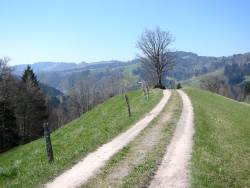 Broad track leading up from Steg  Glimpse of Schnebelhorn summit between trees 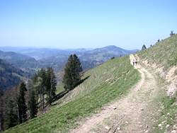 Looking back down the track 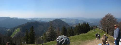 Panorama from Schnebelhorn summit |
Steg lies on the S-bahn line S26 between Winterthur and Rapperswil, giving hourly connections in both directions.
From Zurich there are two possible routes, roughly equal in time (around an hour), either via Winterthur or via Rüti (ZH). In most cases, the best ticket to get is the "9-Uhr" ticket - this gives you access to the whole canton for the whole day (after 9am on weekdays, the whole day on weekends). This is available from the machines and costs CHF 10 with halbtax. This is (marginally) cheaper than getting an Anschlussbillett for your city ticket, should you already have one.
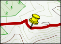
For a zoomable, scrollable map of this hike, see this online map using Openstreetmap or Opencyclemap.
You can also download this kmz file schnebelhorn.kmz (4 kb) to open it in programs like Google Earth or GpsPrune and then transfer the track to your GPS.
Steg - Hirzegg - Schnebelhorn - Tierhag - Stralegg - Orüti - Steg
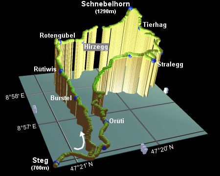 |
From the train station at Steg, turn right following the signposts towards Hirzegg and Schnebelhorn. These lead along the main road at first, but shortly lead left up a steep track climbing up to reach Burstel after around 45 minutes. The village is soon left behind, giving views out over the green, rolling Zürcher Oberland.
Continue to climb, still signposted Hirzegg and Schnebelhorn, following a ridge which drops away on both sides. Shortly you reach Rütiwis, and continue following the Hirzegg / Schnebelhorn signs. After some more climbing, the path splits, with the lower, right-hand path marked as a "Schmaler Weg" (narrow path), and an implicit recommendation for the wider, higher route. Under particularly slippery conditions the Schmaler Weg may be a bit tricky, but it would be a shame to miss this narrow, interesting path around the steep hillside with its wide views, especially as it cuts off an unnecessary climb. Either way, the routes meet up shortly before Rotengübel after around 40 minutes.
Here the route points directly at the Schnebelhorn, although it requires a short descent to Hirzegg before the tackling the final summit. If such grand terms can be used for a peak under 1300m! Climbing the grassy slopes, you are likely to see model gliders soaring round the ridge, whistling their way to top speed as they swoop down for another loop-the-loop. And soon the cluster of people on the small round summit mark the high-point of the walk (around 45 minutes from Rotengübel), and chance for a panoramic backdrop to your picnic. From the rolling green hills nearby, to the flatter lands to the North, round to Säntis soaring up into the snow, the Glarner Alps and across to the two distinctive Mythens, it's not bad at all. And thankfully there's no busy car park at the top, or restaurant, just the quiet views.
As you reluctantly leave the summit, you'll find two possible routes down to Tierhag. The first, most direct, takes you to the right, down a rather steep descent, with plenty of rootiness and loose stones. If you'd rather avoid that kind of thing, then from the top of the Schnebelhorn, continue on the "Toggenburger Höhenweg" signposted for Schindelberg, and then double back to the right, signposted Tierhag. This way is longer, but less steep and much less tricky.
From Tierhag (where there is a restaurant), follow the signs for Stralegg, descending on a broad track to Hinter Stralegg and joining the road to Stralegg, after around half an hour.
Continue on the road, signposted Bärloch, where the route on to Orüti shortly splits, giving a choice between the road and a Fussweg. Take this opportunity to leave the road, taking the narrow path downwards to the right. This leads out onto another track, to reach Orüti after around an hour.
From Orüti, you should follow the signs (not surprisingly) to Steg Station, leading across a bridge over the river, and along a path following the left bank downstream. When you reach the car park at Breitenmatt, the signs lead along the road to Steg, from where you can retrace your outward steps back to the station.
Very disappointingly, there's no chance of a post-hike cake in Steg while you wait for your hourly S-bahn. Although if you feel the need for rude, dismissive service and displays of astonishment that a non-local would have the temerity to try to ask for something, then you'll find everything you need at the Restaurant Bahnhof, just by the station. And they also sell drinks.
The following are the coordinates for waypoints along this route, obtained from GPS. They can be used either in another
GPS, or along with a map, to provide additional references if necessary.
                           Latitude       Longitude    Altitude(m)
       Steg Station       N 47°21'12.6    E008°55'59.0     695
       Burstel            N 47°20'45.2    E008°57'04.0     860
       Rütiwis            N 47°20'48.4    E008°57'45.1     940
       Rotengübel         N 47°20'42.6    E008°58'24.8    1070
       Hirzegg            N 47°20'21.8    E008°58'28.9    1050
       Schnebelhorn       N 47°19'32.0    E008°58'46.4    1292
       Tierhag            N 47°19'24.8    E008°58'30.3    1140
       Hinter Stralegg    N 47°19'20.4    E008°57'42.9    1033
       Stralegg           N 47°19'37.5    E008°57'19.1    1054
       Bärloch            N 47°19'51.5    E008°57'38.5    1050
       Orüti              N 47°20'27.5    E008°56'39.5     724
       Breitenmatt        N 47°20'38.9    E008°56'05.1     710
For a longer walk, with more spectacular panoramas from the Bodensee round to the Zürichsee, continue on the Toggenburger Höhenweg to reach the viewpoints of Chrüzegg and Tweralp, before descending to Wattwil. Regular S-bahns then bring you back through Uznach to Rapperswil, where you're back inside the ZVV zones. Or go the whole hog and do the entire Toggenburger Höhenweg!
The S-bahn plan showing how to get there is on the zvv.ch site. And there are alternative hike descriptions (in German) at tourenguide.ch and steinerpulimeno's site.