
This section of the website gives some basic details about trekking in the Annapurna area of Nepal. The following are popular and easy treks, also known as "tea house" treks, and don't require any mountaineering skills, ropes, glacier crossings or scrambles.
Because no GPS equipment was available during these treks, any coordinate or elevation data is guesstimated based on maps and therefore only a rough guide.
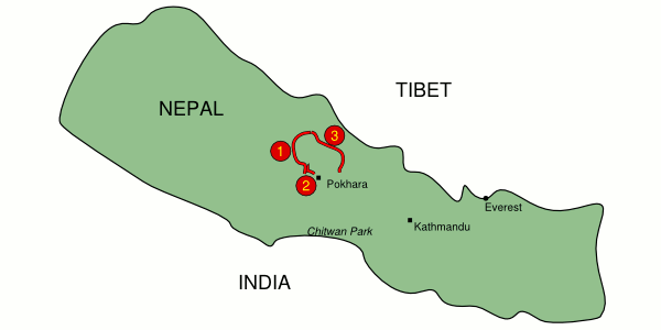
Here's a map of Nepal showing (roughly) where the hikes are. Click on the numbers, or use the summary below.
| Name | Length | Distance | Everests | Summary | ||
1
|
Jomsom trek | approx 8 days | approx 100km | approx 0.5 | Following the Kali Gandaki river in an arc northwards to Jomsom or Muktinath. |
|
2
|
Ghandruk trek | 4 or 5 days | approx 25 km | approx 0.17 | Easier loop trek with views of Annapurna peaks and Machapuchare. |
|
3
|
Annapurna circuit | approx 20 days | approx 220km | approx 1.2 | A longer trek anticlockwise around the whole Annapurna area, crossing the 5400m pass of Thorung La. |
Please note that all times and distances are approximate, and the paths may have changed since the hikes were researched. If you're trekking alone, rather than with an organised guided group, it's best to get a detailed description and a map for navigation. Lots of tour companies organise treks as part of a set itinerary, which means not only is the accommodation booked and the navigation is taken care of, but the food is organised and even the bags are carried for you.
Kmz files are provided, which you can open in Google Earth or GpsPrune to show the routes - these are indicated by the ![]() icon.
icon.
Also, please feel free to share your experiences. Any additional information, corrections, suggestions and comments would be gratefully received by email - all due credit will be given.
| Name | Summary | Link |
| Annapurna Base Camp | Following the Modi river valley north of Ghandruk, this trek heads straight towards the famous Machapuchare before turning left into a dead end valley to Annapurna Base Camp (ABC) at over 4100m. Because this inhospitable place is an ampitheatre, the only way out is back the way you came. | |
| Everest Base Camp | Following in the footsteps of those daring to climb the highest mountain in the world, although apparently the views of Everest aren't the best from so close up. | Wikipedia link |
| Great Himalaya Trail | A mammoth 1800km trail across the whole country, for much of its length not far from the northern bodrer. | thegreathimalayatrail.org |