
Hike time: | 4 hours |
Approx dist: | 12 km |
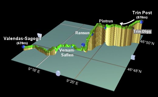
Start: | Trin Post bus stop |
Finish: | Valendas-Sagogn station |
Season: | All Year |
Profile: | From 870m down to 670m, with ups and downs inbetween |
Rating: | medium length, medium difficulty |
Greeting: | "Gruezi", "Gruezi mitenand" |
This walk explores close-up the Rhine gorge area which also appears (through the train window) on the Disentis-Sedrun walk, and also in the canoeing section. Huge amounts of debris from an old landslide have been shaped and eroded by the Rhine river, forming tall cliffs, creating a landscape unexpected in Switzerland.
This walk meanders through villages and meadows near Flims/Laax, before dropping down into the gravelly gorge and following the river. Some care is required in the middle section, with some narrow, rooty paths into and out of the gorge.
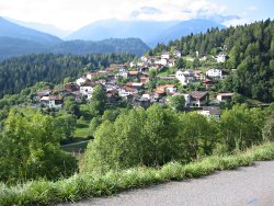 Path curving down to Trin Digg  The broad track winding towards the massive cliffs 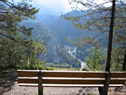 Picnic bench with a view at Ransun 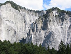 Strange scupltured walls of the gorge  Rafting the white water |
The start of the walk is at the bus stop "Trin Post", reached in about half an hour from Chur. Hourly buses run this route towards Flims. Note that Trin also has a railway station, some way away, and several post bus stops apart from this one. The end of the walk is at the train station of Valendas-Sagogn, which is on the line between Chur and Disentis.
From Zürich, take the train to Chur (1h15) and then a postbus to Trin Post (30 mins). The return journey is a train from Valendas-Sagogn to Chur (30 mins) and then the train back from there.
For a zoomable, scrollable map of this hike, see this online map using Openstreetmap or Opencyclemap.
You can also download this kmz file trin_valendas.kmz to open it in programs like Google Earth or GpsPrune and then transfer the track to your GPS.
 |
In order to avoid walking along the main road, we'll first take a small detour along a parallel lane through the village. The signposts for "Trin Digg" lead across the road, then left between the chickens, along a slightly higher lane, and then down to cross the main road again after a few minutes.
A narrow paved lane curves ahead down the picturesque hillside to the left of the main road, to arrive at Trin Digg after 15 minutes. Here the route joins the Senda Sursilvana (the same route encountered on the Disentis-Sedrun walk) coming from Tamins. Continue on with signposts to Pintrun, as the route passes through meadows with towering peaks around. After half an hour, the path leaves the wide track to the left, and starts to descend. The red-and-white markings lead down steeply through the trees, and then the signs to Pintrun lead across the river and back up another steep narrow trail, to reach Pintrun after 15 minutes.
Following signs to Ruin Aulta and Ransun, we shortly leave the Senda Sursilvana again, before finally gaining views of the gorge at Ransun after 20 minutes. Here there is a perfect barbeque area with great views. The trail then heads from the picnic bench down a steep, rooty track down into the gorge itself, crosses the river using the railway bridge, and then up a steep path on the other side to another good lookout point after another 20 minutes.
Descend once again down the other side of this narrow ridge, still following "Ruin Aulta" signs, and join the railway and river for 20 minutes to the station Versam-Safien. This station makes an alternative end-point, to cut the walk shorter should you wish.
The high gravel slopes whisper and clatter as the relentless erosion continues, and the wind can easily trigger a trickle of small rocks. Follow the sporadic red-and-white signs up the gravel ridge and then on an undulating course not far from the railway. After half an hour, the trail turns away sharply to the left, signposted Ruin Aulta and Valendas-Sagogn, and climbs back into the trees. After the woodland excursion, the path emerges by the river again, passing underneath and then crossing a bridge over a side-stream. Due to the huge amount of debris washed down recently, you'll have to duck to cross underneath the railway! From here, just follow between the tracks and the river to reach the station at Valendas-Sagogn after around 45 minutes.
The following are the coordinates for waypoints along this route, obtained from GPS. They can be used either in another
GPS, or along with a map, to provide additional references if necessary.
                           Latitude       Longitude    Altitude(m)
       Trin Post          N 46°49'42.0    E009°21'42.9     872
       Trin-Digg          N 46°49'29.6    E009°21'20.8     814
       Pintrun            N 46°49'14.7    E009°19'59.1     802
       Ransun             N 46°48'32.4    E009°19'40.6     805
       Bench              N 46°48'22.2    E009°19'19.5     694
       Versam-Safien      N 46°48'26.5    E009°18'37.7     635
       Valendas-Sagogn    N 46°47'30.5    E009°16'31.9     669
The site trin.ch has a town plan of Trin, and the canoe school at Versam has some photos of the area in the Fotogallerie. If you want to get a slightly closer look at the river here, you can go canoeing or rafting through the gorge.