
Hike time: | 3.5 to 4 hours |
Start: | Rigi Scheidegg cable car |
Finish: | Rigi Kulm bahnhof |
Season: | All year round |
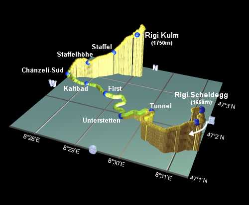
Profile: | from 1660m down to 1440m, then up to 1800m |
Rating: | easy walk with a steep final climb |
There are many possibilities for walks on Rigi, but this recommendation describes the spectacular route from Rigi Scheidegg to Rigi Kulm. The path is well-marked, well-maintained (even in Winter), and as far as Rigi Kaltbad it's surprisingly level, because this stretch was originally built as a railway line. This makes it suitable for family trips, so it can get very busy in good weather! Deservedly so, though, because the views are spectacular and as the path winds its way gradually around the mountain, the scenery is constantly changing. From the very start of the walk, there are rich views of the Mythens and the Bernese Alps; from the popular rest-stop at Unterstetten the view unfolds to reveal Pilatus; from Chänzeli you feel suspended right above Lake Luzern; and from the summit of Kulm your reward is a complete panorama including the Zugersee and Säntis
Walking time is about 3.5 hours, although you should allow more time in Winter. There's a total altitude gain of about 400m, almost all of which is in the last hour, although if you don't feel like the final ascent, you can always get the train up from Rigi Staffel to Rigi Kulm, which will save you about 200m. The actual summit is about 5 minutes walk further up from the station at Kulm, and highly recommended in clear weather.
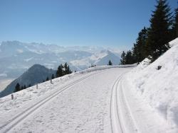
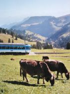
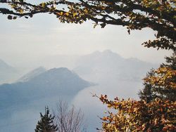
 The panorama to the South from near Scheidegg  The perfectly prepared walking path high above the scenery  The cows enjoying a more Summery day  Looking down to Lake Luzern and the Burgenstock peninsula |
The start of the walk is reached from the station at Arth-Goldau by taking the Rigibahn up to Kräbel, and then the (tiny) cable car up to Rigi Scheidegg. Arth-Goldau itself is a major train junction, with many connections. The end of the walk is at Rigi Kulm, from which the cogwheel trains descend either to Arth-Goldau or to Vitznau.
From Zurich, this makes an easy day trip, with the possibility of taking a boat trip across Lake Lucerne (the Vierwaldstättersee) as well. This varied round trip takes in a train to Arth-Goldau, cogtrain and cable car up to Rigi Scheidegg, cogtrain down from Kulm to Vitznau, boat across the lake to Luzern and then (after a look around) the train back from Luzern to Zurich. Or, for a shorter trip (especially when the days are shorter), you can instead take the cogtrain down from Kulm to Arth-Goldau and head straight back to Zurich from there.
Occasionally, there may be a special offer ticket (ask at the station or tourist information), this can work out slightly cheaper, and gives you a coupon to spend at one of the restaurants on Rigi.

For a zoomable, scrollable map of this hike, see this online map using Openstreetmap or Opencyclemap.
You can also download this kmz file rigi.kmz to open it in programs like Google Earth or GpsPrune and then transfer the track to your GPS.
Rigi Scheidegg - Unterstetten - First - Rigi Kaltbad - Chänzeli - Staffel - Rigi Kulm
 |
Pick up the free Rigibahn timetable (Fahrplan) from the station at Arth-Goldau, as it includes a very useful map showing the footpaths (there are different maps for Summer and Winter).
After savouring the views from the lookout at Rigi Scheidegg, there appears to be a broad path leading upwards towards the restaurants and ski area, but the main footpath actually heads downwards to the left, towards the houses. This drops in a couple of switchbacks to Hüsli before traversing the side of the ridge underneath the main village. This stretch towards Kaltbad takes you along an old disused railway line converted into a footpath. Good news, because as well as being level, and wide, and in good condition, it has even got its own (short) tunnel, and at Unterstetten a large bridge. With the panoramic views as well, it's easy to see why the walking on this stretch is especially popular.
From Unterstetten (a good picnic stop), the path continues to First and then follows the signs to Rigi Kaltbad. This is at the top of the Weggis cable car, and also on the Vitznau rail line, and is therefore geared up with hotels, restaurants and so on.
The signs now lead to Känzeli (or Chänzeli), and an amazing church wedged in between the rocks - a big surprise if you're expecting the path to go that way! And there's yet another superb lookout point, with Lake Lucerne seemingly directly below your feet. Several steep switchbacks now take you up to Staffelhöhe where you rejoin the train line up to Rigi Kulm. Through Staffel the path climbs up to the left above the tracks but never gets too far away, until eventually the path reaches the station at Kulm.
After checking the train times, there's just another 5-10 minutes climb up to the summit, an inviting, broad grassy slope with the obligatory panorama boards, and yet more photo opportunities.
The following are the coordinates for waypoints along this route, obtained from GPS. They can be used either in another
GPS, or along with a map, to provide additional references if necessary.
                           Latitude       Longitude    Altitude(m)
        Scheidegg         N 47°01'39.1    E008°31'20.6    1665
        Hüsli             N 47°01'34.1    E008°31'18.6    1610
        Tunnel            N 47°01'58.0    E008°30'11.3    1508
        Unterstetten      N 47°01'53.1    E008°29'30.2    1452
        First             N 47°02'24.3    E008°28'44.7    1453
        Kaltbad           N 47°02'38.7    E008°28'00.9    1438
        Chänzeli-Sud      N 47°02'44.3    E008°27'21.3    1464
        Staffelhöhe       N 47°02'54.6    E008°27'52.6    1550
        Staffel           N 47°03'13.3    E008°28'26.5    1603
        Kulm              N 47°03'18.7    E008°29'03.7    1744
There's a home page at rigi.ch, with hiking suggestions described (mostly shorter hikes than this one). Unfortunately their excellent map has been removed from the website - you can pick this map up free from the Rigibahn station in Arth-Goldau instead. This makes Rigi-Scheidegg look deceptively low compared to Kulm, but don't worry - it's not as steep as it looks!
For those who prefer leg power to motorised travel, you can hike up to Rigi Scheidegg instead of taking the cable car. The path up from Arth-Goldau (at 510m) is fairly easy (although offers a hefty climb) and well signposted to Rigi Scheidegg. It passes through Ochsenschneu and Rotenflue Allmig, and meets the described route at Hinter Dossen, not far below Scheidegg itself.
Another alternative hike, heading in the opposite direction from Scheidegg away from Kulm, is described at gruxa.ch, passing through Burggeist, Sören, Chellensack, Gätterli, Egg, Bärfallen, Dörfli and Wilerbrugg to reach Brunnen (with trains back to Arth-Goldau) after around 4 hours.
And lastly, along the Rigi ridge between Scheidegg and Brunnen towers the Rigi Hochfluh, an outcrop of dramatic sheer rock and home of some, shall we say, interesting hiking routes for the adventurous. Marked with the blue-and-white splashes of the distinctly more challenging routes, there's a spectacular path from Timpel (reached either by foot or by cable car from Brunnen) via Schwand up to Hochfluh giving amazing views over both the Vierwaldstättersee and Zugersee. Be warned though, this is exposed, narrow, precipitous and not for the faint-kneed! From there you can loop back down (long descent!) through Zilistock and Bärfallen back to Brunnen.