
Hike time: | 4 hours |
Start: | Postbus Oberbalmberg |
Finish: | Solothurn Bahnhof |
Season: | Summer |
Profile: | from 1060m up to 1400m, then down to 400m |
Rating: | easy apart from medium descent to Falleren |
Greetings: | "Grüezi" |
The Weissenstein is "Solothurn's mountain" with a peak at Röti (1400m). This walk takes in this peak, and the spectacular panoramic views available, before descending towards Solothurn. The last part of the walk is a fairly level stroll, passing along the way through a magical fairy-tale chasm at Einsiedelei.
This walk can easily be extended to take in an interesting natural spectacle - real, 150 million year-old dinosaur footprints not far from Oberdorf. And Solothurn itself has an attractive old town which is worth an explore after the end of the hike.
The start of the walk is at Oberbalmberg, which can be reached by post bus from Solothurn station. Check the SBB website for details, these buses are currently running every two hours, and take around half an hour to struggle up the steep roads to Oberbalmberg, which is the final stop.
From Zurich, there are direct trains to Solothurn (1 hour), which connect conveniently with the post bus, making this a very easy day trip. The return journey is just the direct train back from Solothurn. It's easiest to get a return ticket to Solothurn (CHF 31 with halbtax) and then buy the single post bus ticket (CHF 4 with halbtax) from the driver.
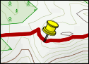
For a zoomable, scrollable map of this hike, see this online map using Openstreetmap or Opencyclemap.
You can also download this kmz file weissenstein.kmz (4 kb) to open it in programs like Google Earth or GpsPrune and then transfer the track to your GPS.
Oberbalmberg - Nesselbodenröti - Röti - Nesselboden - Stiegenlos - Einsiedelei - Solothurn
 |
The post bus stops just by the Hotel/Restaurant Kurhaus in Oberbalmberg, and already there are expansive views over the flat surroundings. A signpost right in front of the restaurant directs you along a level path, signposted "Nesselbodenröti", which after a small bridge, turns into a trail climbing straight up the slope. Alternating between steep switchbacks and level sections, the route reaches a small viewpoint, before dropping slightly to a signpost above a wide gulley, after around half an hour.
At this signpost, turn right towards Röti, almost immediately reaching a track junction at Nesselbodenröti. Take the rightmost of the three tracks, again marked "Röti", and climb up between the trees. This emerges onto the grassy top after around 25 minutes, going past a wooden crucifix to the summit itself, marked by a triangular metal marker and a signpost. The views from here are fantastic. Although this is a long way from the Bernese giants, the land between the Jura and the Alps is remarkably flat, providing stunning views and a real sense of distance.
The signpost at the summit (for "Weissenstein") points a bit too far to the right, don't cross the fence but follow its line away from the summit to meet another signpost lower down. This leads you gently downwards across the grassy field, passing to the right of a barn before dropping down to the right. Here it meets a light-coloured track rising up to a telecomms mast and then the Hotel Weissenstein, after around 20 minutes. The unusually-shaped Bergkapelle just before the hotel is worth a visit. The hotel has a marvellous outlook from its large terrace, with panorama boards to help spot the famous peaks - the only downside is the noisy chairlift machinery right next door.
From the rear of the hotel, follow the signpost towards Nesselboden, down a stepped path to meet the road. Here, turn left and cross in front of the Bergrestaurant Sennhaus, before taking the track on the right towards Nesselboden. This track drops fairly steeply and can be fairly slippy in parts, but eventually reaches Nesselboden, at the intermediate station of the chairlift, after around 20 minutes.
From Nesselboden, there is a worthwhile 5 minute excursion up to the Antennae, giving yet more panoramas to the South. This is a good quiet spot from which to gaze at the views and watch the paragliders soar overhead. Returning back to the junction, the main route follows the signposts to Stiegenlos, but there is a detour available to take in the dinosaur footprints near Oberdorf. This adds somewhat over an hour to the hike, and around 100m of climbing, and rejoins the main route in Stiegenlos, as follows:
Detour: From Nesselboden, turn right down the paved road, and then right again signposted "Oberdorf". This track descends gradually at first to pass under the chairlift, and then fairly steeply towards dramatic rocky cliffs. When it meets the road, cross the bridge and follow the brown signs for "Saurierspuren", reaching the wooden viewing platform after around 45 minutes. The information boards are only in German and French, but the diagrams explain quite clearly what happened. From here you can continue to Oberdorf for a train connection, or return as follows to the main route. Retrace the route back to the bridge, and then follow the road uphill signposted "Stiegenlos". When it reaches the chairlift cables, continue on the signposted track to rise steadily up to Stiegenlos after around 40 minutes.
From Nesselboden, follow the track signposted Stiegenlos - this descends to the left of the Antennae, and branches off from the more obvious track swinging around to the left. Soon this track becomes quite steep, and helpful cables have been placed at strategic points on the narrow, rocky switchbacks. After around 25 minutes, you reach a signpost at Stiegenlos, where the detour rejoins this route.
Ten more minutes of switchbacks brings you down to a broad, smooth track, and another 10 minutes on here leads out to Falleren, and the end of the forest section. Cross the main road and follow it towards Einsiedelei, occasionally looking back at the imposing ridge which you've just climbed down. The yellow signs lead you left and then right to reach Einsiedelei after 15-20 minutes.
This popular gorge might be a little crowded for the average hermit, but it's a beautiful spot with a mystical atmosphere. The tiny buildings seem to be growing out of the rock (or being squashed by it), and the open church is especially tranquil with the cavern, shrine, the sound of rushing water and the many candles. In fact, candles or lamps form a theme for this riverside walk, as they appear in the most unlikely nooks and crannies along the way. Our route leaves the main, rising track and closely follows the river, marked with yellow arrows, to reach Wengistein after 10-15 minutes.
Our last stage of the route follows the signposts to Solothurn Bahnhof along residential roads, with a barely-marked left down
Fegetz-Allee and then right towards town. A subway takes you under the main road, and then straight ahead you'll find the main station,
at the end of Rötistrasse.
The following are the coordinates for waypoints along this route, obtained from GPS. They can be used either in another GPS, or along with a map, to provide additional references if necessary.
                           Latitude        Longitude    Altitude(m)
     Oberbalmberg        N 47°15'49.6    E007°32'21.2     1058
     Signpost1           N 47°15'15.8    E007°32'21.5     1213
     Nesselbodenröti     N 47°15'16.5    E007°32'15.1     1222
     Röti                N 47°15'28.8    E007°31'41.0     1396
     Hotel Weissenstein  N 47°15'05.4    E007°30'30.0     1278
     Nesselboden         N 47°14'44.6    E007°30'32.3     1057
     Stiegenlos          N 47°14'31.7    E007°30'48.0      805
     Falleren            N 47°14'02.9    E007°31'27.7      555
     Einsiedelei         N 47°13'28.7    E007°32'00.6      493
     Wengistein          N 47°13'11.1    E007°32'30.6      455
     Solothurn           N 47°12'15.9    E007°32'35.7      427
     Dinosaurs           N 47°14'09.5    E007°28'37.2      751
The Solothurn city site can tell you more about the town, with some details about Einsiedelei and the Dinosaur prints under 'Trips'. The site for the Hotel Weissenstein has information on the hotel and restaurant, and a live weather cam. Also there's some info in German about the dinosaur prints on the lommiswil.ch site or on the wayback machine's version of the old solothurn.cc site.
The Jura Höhenweg passes right by the Weissenstein on its way west towards Obergrenchenberg.