
Hike time: | 5 hours |
Approx dist: | 15 km |
Start: | Glarus |
Finish: | Glarus |
Season: | Spring-Autumn |
Profile: | from 470m up to 1100m and back |
Rating: | mostly easy paths, just a few steeper bits |
Greetings: | "Grüezi" |
The Klöntal is a small valley hidden away off the side of the Glarus valley, just West of the town of Glarus. In it is the attractive Klöntalersee, which is dammed for hydroelectricity and flanked by the impressive Glärnisch range looming above to the South. This Glärnisch range, still topped with snow, is visible from Zürich (on those rare clear days) as the dramatic ridge in the distance beyond the lake.
This walk makes a loop, climbing up from Glarus through the forest up to Schmwammhöchi where you get fine views down to the lake below. After descending down to the lakeshore itself at Rhodannenberg, where you can admire the greeny-turquoise hue of the waters with the rocky cliffs behind, it follows the stream downhill back to Glarus.
There are several options for shortening this walk, using the bus services to/from Rhodannenberg or Vorauen. You could also extend it to a 2-day hike, crossing over to the Obersee near Näfels or over the Pragelpass to the Muothatal.
 View of Glärnisch from Vorder Saggberg 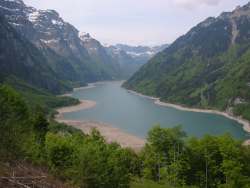 View of Klöntalersee from Schwammhöchi 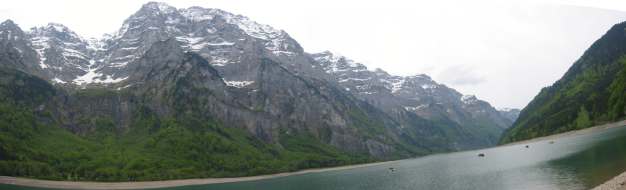 Glärnsich ridge above the Klöntalersee 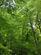 Leafy forest in the Klöntal |
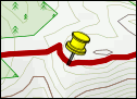
For a zoomable, scrollable map of this hike, see this online map using Openstreetmap or Opencyclemap.
You can also download this kmz file kloental.kmz to open it in programs like Google Earth or GpsPrune and then transfer the track to your GPS.
Glarus is a major station in the Glarus valley, indeed it's the capital town of the canton. There are trains at least hourly up and down the valley between Ziegelbrücke and Linthal.
From Zürich, some of the trains are direct to Glarus and some require a change in Ziegelbrücke. Either way, it takes around an hour each way and the return ticket costs CHF 23 with halbtax.
Glarus - Bleiche - Vorder Saggberg - Schwammhöchi - Klöntalersee - Rhodannenberg - Lötschtobel - Bleiche - Glarus
 |
From Glarus train station, follow the signposts to "Klöntalersee" along the main road into town. Follow this road as it bends round to the right, and then take the left into Kirchstrasse to go round the left-hand side of the church. Jink through the expanding residential area following the yellow signposts through Feld and Oberdorf to Bleiche.
From Bleiche the signposts lead upwards through the trees and fields, emerging onto another road. Turn left here, following the paved road downhill a short way to the bend, before turning right up the track, past the cows and starting to climb in earnest. The gravel track ascends fairly steeply in parts, before flattening out where it emerges at the alp of Vorder Saggberg, an idyllic meadow with the dramatic snowy peaks of the Glärnisch range peeking out above the trees.
The path now curves round to the left, still climbing, and crosses a track and a road before jinking back through the trees. Shortly the path pops out onto another road, and climbs the last short stretch to Schwammhöchi, where you get the great panorama looking out over the Klöntlaersee a surprisingly long way down, and the Glärnisch range stretching out to the left. The Bergrestaurant Schwammhöhe sits here at 1100m with the perfect vantage point from the terrasse.
After having gazed at the view and refreshed oneself from the climb, it's eventually time to tear oneself away and begin the descent. Initially following the road down to the left, the signposted path takes a few shortcuts to skip the hairpins, descending quite steeply through the trees to the lakeshore at Weiden. This lake being dammed for hydroelectric power, the level of the water can vary quite dramatically and so it can be that the shore is rather bare - however the water is a magical blue-green and the contrast with the massive sheer cliffs beyond is super. Turn right here and walk along the edge of the lake to reach Rhodannenberg where the Hotel Rhodannenberg and the post bus stop await you. If you've had enough by now, the infrequent post bus can take you back to Glarus from here.
On the corner of the road by the Hotel, a path signposted for Glarus leads down to the river and follows it downstream, crossing it several times with footbridges. At Löntschtobel the path passes an impressive gorge where the streams meet, and continues to follow the flow (and the road) until it pops out at Sitli, not far from Riedern. From here, follow the signposts for Oberdorf (following the rural Talfussweg for part of the way) to join the outbound route at Bleiche. Here you can just retrace your previous steps through Oberdorf and back to Glarus station.
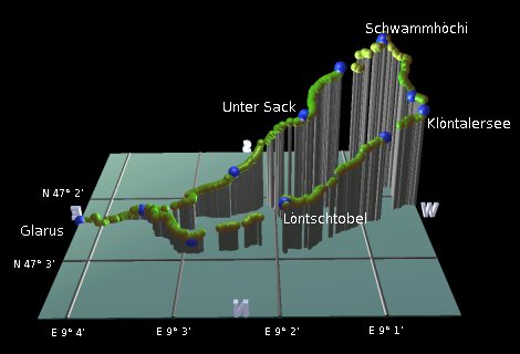
The following are the coordinates for waypoints along this route, obtained from GPS. They can be used either in another GPS, or along with a map, to provide additional references if necessary.
                           Latitude       Longitude    Altitude(m)
       Glarus station     N 47°02'22.9    E009°04'16.4     470
       Oberdorf           N 47°02'21.3    E009°03'32.7     509
       Bleiche            N 47°02'25.5    E009°03'23.6     520
       Unter Sack         N 47°02'17.6    E009°02'28.0     646
       Vorder Saggberg    N 47°02'24.1    E009°01'41.0     880
       Stelliwaldhütte    N 47°02'09.8    E009°01'16.6    1015
       Schwammhöchi       N 47°02'02.9    E009°00'48.0    1100
       Näggeler           N 47°01'51.5    E009°00'46.2    1065
       Weiden             N 47°02'03.6    E009°00'25.6     891
       Rhodannenberg      N 47°02'08.7    E009°00'18.6     851
       Haselteufe         N 47°02'23.8    E009°00'47.7     794
       Löntschtobel       N 47°02'53.1    E009°01'55.2     655
       Sitli              N 47°02'53.6    E009°02'54.6     519
This walk is described in German at glarnerwanderwege.ch including a sketch map and a rough contour profile. There's a shorter walk described (also in German) at wandersite.ch going along the lakeside from Rhodannenberg to Vorauen.
Two restaurants in this area also have websites - the Bergrestaurant Schwammhöhe and the Hotel Rhodannenberg (flash only).