
 |
This is the third stage of the Alpine Pass Route. It starts from Linthal, in the valley Southwest of Glarus, and after two days' walking, finishes in Flüelen on the shores of the Vierwaldstättersee (Lake Lucerne). On this section we differ a little from some descriptions of the Route, as a more usual destination is Altdorf, a larger town close by to Flüelen. However, there are good reasons for the diversion - firstly the way described here follows a scenic Höhenweg along the side of the Schächental valley, rather than a busy urban road to Altdorf. Secondly, it provides views of the Vierwaldstättersee and the peaks to the West, and thirdly (for those enjoying the route in several pieces), Flüelen has more frequent train connections than Altdorf, as it is on the main line between Ticino and Zürich.
The Klausenpass itself is quite different in character to the previous passes on this route, the Foopass and the Richetlipass, because unlike the others, it has a very popular road running over it. So rather than sharing the tranquil scenery with a handful of other hikers, you're sharing this crossing with about three and a half thousand motorcyclists and almost as many cars. On a sunny weekend, the constant frantic droning can get a bit much on the first of these two days.
Linthal is at the end of the train line from Ziegelbrücke, with hourly connections. Flüelen is a stop on the main North-South line, with very frequent trains through Schwyz and Arth-Goldau to Zürich, and through Göschenen and Bellinzona to Chiasso.
From Zürich, you just need to change at Ziegelbrücke to get to Linthal in about 1h40 (CHF 13 one-way with halbtax). Returning from Flüelen, a change in Zug or Arth-Goldau might be necessary, but these still take about 1h15, the same as the direct trains (CHF 11 one-way with halbtax).
The most conveniently-situated place to stay on the way is the Hotel Klausenpasshöhe, a short distance beyond the pass itself. Here they offer places in a 16-bed dorm for CHF 35 including breakfast, in a basic but modern block. The other options are in the village of Urnerboden, for example the Gasthaus Urnerboden or the Gasthaus Sonne (see urnerboden.ch), but this makes the second day rather longer.
For the end of the walk, at Flüelen, Altdorf or Attinghausen, see the searchable list of accommodation at i-uri.ch.
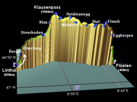
Linthal - Oberberg - Urnerboden - Klausenpass - Mettenen - Biel - Ruogig - Eggbergen - Flüelen
Hike time: | 6.5 hours |
Approx dist: | 21 km |
Start: | Linthal station |
Finish: | Klausenpass |
Profile: | from 650m up to 1950m, then drop to 1800m |
Rating: | easy to medium |
Starting from the railway station at Linthal, one popular route is to climb up to Braunwald (either by footpath or by taking the cable train) and traversing across to the Urnerboden valley from there (see the Urnerboden map under links for a panoramic view). However, I was lured by the signposts urging me to sample the "Historischer Weg" along the lower route, as this Alpine Pass Route is supposed to be historic after all. It doesn't make a lot of difference, as the paths join up sooner or later anyway, but the Braunwald way stays clear of the roads for longer and gives very nice panoramas out over the Glarus valley.
Taking the more direct route, follow the "Historischer Weg" signposts for Urnerboden and Klausenpass along the flat valley floor towards the hanging valley spied on the previous day. Shortly, these lead away from the road, past the reservoir, and along a lane by the stream. A path then leads off up to the right, climbing up steeply to meet the road again, before short-cutting up the grassy hillside to reach the Gasthaus Bergli after around 45 minutes. This fabulously-situated restaurant also has a limited number of double rooms available, and is a popular stop for the road-warriors.
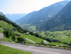
Looking from Bergli back down to Linthal
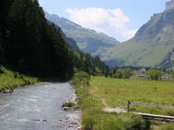
Path alongside river in the upper valley
The footpath then continues uphill with red-and-white paint splashes guiding the way through the cow fields. It climbs up to join the road a couple more times, before leaving to the left and levelling out on a winding path by the river. Emerging by a bridge, you join the road again by an impressive collection of boulders, and follow the road for a short distance on the now open and flat valley floor. You are then guided leftwards down a track through a gravel works and through an extraordinarily popular stream-side camping and sunbathing area. As you stroll by the side of the stream, the huge rock walls up to your right may remind you a little of the Churfirstens, with their stark, sheer, toothiness.
Looking ahead, you can see the impending pass almost visibly steepening, but for the time being the terrain
is flat and easy. A bridge brings you over to the right-hand side of the stream, where you continue your
passwards journey, and shortly spy an elevated outcrop with a white church on top. This is the village of
Urnerboden, reached in around 2 to 2.5 hours from Gasthaus Bergli, with a very welcome drinking fountain
just next to the white church.
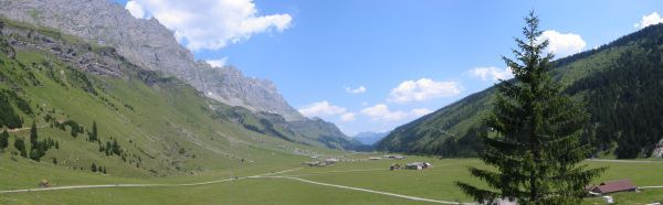
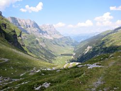
View from Urnerboden back down valley
From Urnerboden, retrace your steps back down past the Seilbahn to the river, and continue upstream following the red-and-white splashes. Shortly they lead away from the stream, taking a path past a drinking fountain to meet the road at a hairpin bend.
A track then climbs away from the road to the left, with numerous impressive hairpins built on to the hillside.
This must have been the original trade and transport route before the tarmac (and the motorbikes) arrived.

Track hairpinning high above valley
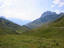
Another view down the Urnerboden valley
This is followed by an irritating road stretch up to Klus (after around 1h20), with a few random grassy shortcuts, before another track leaves to the left, climbing above the road and keeping well to the left.
The final stretch up to the pass is a steady climb, reaching the summit in another 50 minutes or so from Klus.
Here, as well as the views over the other side of the pass, with its wild, craggy landscape, you'll also find a
packed car park, a cafeteria, souvenirs, and perhaps most importantly, ice cream.
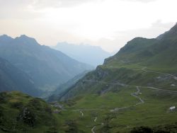
View down the other side of the Klausenpass
Suitably refreshed and cooled, you can now contemplate the onward journey. It's not far now to the hotel, with the faint path leading downwards and straight ahead to the left of the road, signposted Unterbalm. Negotiate the electric fence and descend gently across the cow fields.
After around 25 minutes, you see a brown building up to your right with "Restaurant" written on it, and
hiding next to it is an older, grey building which is the main hotel building. Unfortunately there is no path
leading up, but you can scale the 60m or so with a little perseverance. Ask at the main grey building for details,
but the brown building is the more modern block with the dormitories.
Hike time: | 8 hours |
Approx dist: | 26 km |
Start: | Klausenpass |
Finish: | Flüelen |
Profile: | from 1800m down to 430m with many dips |
Rating: | easy but long |
View from the Hotel Klausenpasshöhe
From the hotel, scramble back down the slope to reach the footpath again (or if you're not haunted by traffic, just follow the road for a short while instead). The footpath drops down to meet the road at a hairpin, from which you need to go uphill to the next hairpin, and leave the road again on the rising track going round the shoulder of the hill. Continue along this gently rising track to reach Heidmanegg after around 45 minutes.
From this Höhenweg, the views out across the valley are spectacular, with waterfalls cascading down the opposite
wall. The path continues to traverse the side of the valley, descending slightly, until the path forks at a signpost.
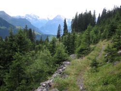
Path traversing above the valley
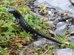
Cute little black salamander
One option is to follow the Spiringen signs to descend to the valley floor, and then follow the main road again (or take the bus) along to Altdorf. However, in order to enjoy the Höhenweg for longer, we will take the right fork steeply uphill, signposted for Ratzi and Biel. This zigzags up to meet a level track to Mettenen, around half an hour from Heidmanegg.
A gravelly road leads downhill signposted Biel, and leads to a variety of paths and tracks marked with paint splashes and signposts. After around 1h20 from Mettenen, you emerge on a road above Ratzi, marked by a signpost.
You then follow the high-level lane around above Ratzi, which regular readers may recognise as a Winterwanderweg
(but only if you have snowshoes) in snowier months. The easy track traverses around a valley inlet, past a second
perfect picnic bench, and forking right up towards Biel and Eggbergen. You reach the upper edge of Biel, a short
distance from the upper cable car station, after around 1h15 from the signpost (somewhat quicker than when up to
one's knees in snow).
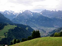
View down towards Bürglen and beyond
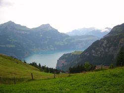
Deep blue/green waters of the Vierwaldstättersee
Take the path signposted for Ruegig and Eggbergen (also part of the Suworowweg), around another inlet on a gently rising track to Ruogig, and another cable car station, after around 30 minutes.
Another half and hour, around another inlet and past the Selez bar, brings you to Flesch, and a small but attractive lake hidden away in a bowl. The signposts are confusing here, but follow the broad track round the left-hand side of the lake, leading on downwards through the evergreen forest. Glimpsed briefly through the trees is a far off lake (the Zugersee?) before eventually the deep blue/green of the Vierwaldstättersee comes into view. After around an hour from Flesch, you reach the small resort of Eggbergen, perched on the steep hillside with a cable car down to Flüelen.
But for those too stubborn to take the cable car, there's a twisty and turny footpath, signposted Flüelen, which zigzags relentlessly down the ridge for about 1h30 before finally emerging by the lake. When you get there, Flüelen station is just a short distance to your left.
Now dip your aching feet in the Vierwaldstättersee, catch your breath, and contemplate the following day's section,
tackling the fourth pass on this route, the Surenenpass to Engelberg.
The following are the coordinates for waypoints along this route, obtained from GPS. They can be used either in another GPS, or along with a map, to provide additional references if necessary.
                           Latitude       Longitude    Altitude(m)
       Linthal            N 46°55'32.1    E008°59'52.7     648
       Rest Bergli        N 46°54'32.5    E008°58'46.0     894
       Oberberg Bus       N 46°54'39.5    E008°58'29.6    1040
       Urnerboden         N 46°53'21.6    E008°54'08.3    1386
       Klus Bus           N 46°52'06.7    E008°52'30.8    1690
       Klausenpass        N 46°52'06.5    E008°51'16.2    1948
       Klausenpasshöhe    N 46°52'19.9    E008°50'13.5    1834
       Heidmanegg         N 46°52'31.1    E008°48'07.8    1862
       Mettenen           N 46°52'43.8    E008°46'48.5    1750
       Signpost           N 46°53'18.9    E008°44'36.2    1695
       Bench              N 46°54'06.8    E008°43'01.0    1695
       Biel               N 46°53'59.5    E008°42'35.5    1715
       Ruogig             N 46°54'12.7    E008°41'14.7    1730
       Selez              N 46°54'34.6    E008°41'07.0    1736
       Flesch             N 46°54'23.8    E008°40'35.2    1812
       Eggbergen          N 46°54'07.3    E008°38'39.7    1440
       Flüelen            N 46°54'06.8    E008°37'27.0     432
The braunwald.ch site has local information for the start of the walk, including maps of the Linthal and Braunwald area in jpg and pdf format. For the first day's section up the Urnerboden valley, see the Urnerboden map from urnerboden.ch. For the suggested route to Eggbergen, see sommerspass.ch, whose 3.8MB aerial map (under the link "Eggbergeplan1.pdf") may be useful for showing the route. And for the cable car down to Flüelen, see eggberge.ch.