
 |
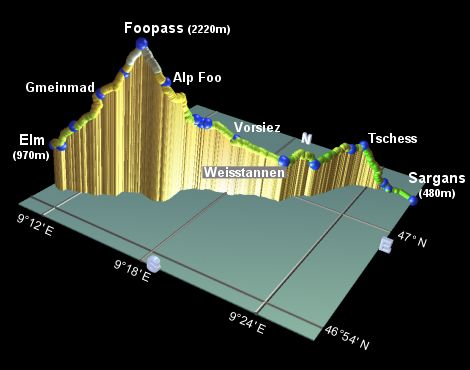
This is the first stage of the Alpine Pass Route. It starts from Sargans, not far from the Liechtenstein border, and heads roughly Southwestwards up the lush Weisstannental valley. The first day is relatively gentle, finishing at the village of Weisstannen deep in the valley. The second day is tougher, as it climbs up the head of the valley to the 2220m Foopass, before dropping down the other side to the town of Elm.
Sargans is a major junction on the Zürich to Chur rail line, and also has rail services North to St Gallen and Austria. It is therefore easily accessible from many directions. A post bus operates between Sargans and Weisstannen, should you wish to join the route there. From Elm, hourly buses run to Schwanden which lies on the rail line between Ziegelbrücke and Linthal.
From Zürich, a direct train brings you to the start of the walk at Sargans. Returning from Elm, an hourly bus brings you to Schwanden, and connects to the train up to Ziegelbrücke. From here a connecting train runs back to Zürich.
A convenient overnight stop is Weisstannen, where you have a choice of a few hotels (see links below). Recommended is the Hotel Alpenhof, offering beds in 8-bunk rooms for CHF 30 including basic breakfast. Accommodation is also available at the Restaurant zur Muehle in Schwendi, but that would make the second day even longer. Another option is at the dairy in Vorsiez, reducing the second day's climb by about an hour. Here they offer mattress-on-the-floor rooms and 3-bed rooms for CHF 30 - 40 including breakfast.
At Elm, there is a range of possibilities, see the Elm website under "Unterkünfte".
Sargans - Mels - Schwendi - Weisstannen - Vorsiez - Alp Foo - Foopass - Raminer Matt - Elm
Hike time: | 4 hours |
Approx dist: | 14 km |
Start: | Sargans station |
Finish: | Weisstannen |
Profile: | from 480m up to 1000m, with some bumps and dips |
Rating: | mostly easy, with some medium bits |
Greetings: | "Gruezi", "Gruezi mitenand" |
The route starts from the railway station at Sargans, and you can immediately see the entrance to the Weisstannental valley through which the route leads. It doesn't look very daunting from here, just a green, verdant valley with a few power cables and a gentle incline.
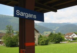
View from Sargans towards the Weisstannental

View back down towards Mels
Initially the way is not too spectacular, as it follows directly beside the railway line back towards Zürich, signposted for Mels and Weistannen. Make sure you don't follow the prominent "Via Alpina (1)" signposts from the station, as these lead in entirely the wrong direction towards Vaduz. Instead stay close to the railway tracks and head to the northwest. You can see the Weisstannental to the left, and the tiny Schloss Sargans to the right, as you follow the tracks to the bridge. Here, yellow marks lead you down steps to the road below, where you turn left and follow the road to Mels, admiring the Churfirstens to the right. The signposts lead you almost past the attractive church of Mels, before jinking up narrow lanes round to the top of the small square Dorfplatz. The signposts are just beyond the square, on the other side of the river - reached in around half an hour from Sargans station.
Following the signs to Weisstannen, the route leads up the narrow road to St Martin, with its tiny chapel and immaculate vineyards, and its views back down to Mels on the valley floor. A little further on up the road, yellow diamond marks lead up a fairly steep trail through the trees, crossing the road a few times before reaching Tschess after about 1h30 from Mels.
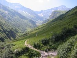
At Tschess we branch left on a gently descending track, still signposted Weisstannen, and shortly the views open out into the Weisstannental itself, from our vantage point high up on the right-hand side. You may well hear the distinctive tones of the post buses plying the route on the valley road below, although they're well hidden from view.
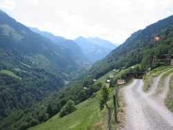
View up the lush Weissental valley
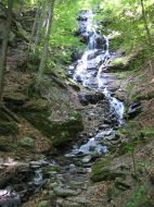
Waterfall beside footpath
After around 20 minutes, you reach Hundbüel, where the route becomes a narrow path, with some rockiness and a bit of rootiness as it winds around the convoluted slopes, before dropping down to Schwendi after another 50 minutes. Here is where the route meets the valley road, which you follow up to the Gasthaus zur Muehle.
As well as being a good refreshment stop, this marks a splitting point for the paths - the easier option is to just follow the road all the way to Weisstannen, but a pleasant alternative, although requiring a bit more climbing, takes a path higher up through the trees. This path is marked from the Gasthaus zur Muehle, winding steeply up the hillside to the right before levelling out towards Weisstannen. After around 50 minutes it drops down to the road just by the Hotel Gemse, with the centre of the village and the Hotel Alpenhof a bit further on by the stream.
As you approach Weisstannen, you'll notice that the valley appears to split here, with one fork heading
leftwards towards the Heidelpass and the right-hand fork leading further up the Weisstannental for tomorrow's stage of the
adventure.
Hike time: | 7 hours |
Approx dist: | 23 km |
Start: | Weisstannen |
Finish: | Elm |
Profile: | from 1000m up to 2220m and back down again |
Rating: | medium but long |
Greetings: | "Gruezi", "Gruezi mitenand" |
From the signposts in Weisstannen, take the right-hand valley road towards Vorsiez, Foopass and Elm, and continue upstream. When the road bends round to cross the river, a track continues straight ahead uphill, with high rock walls looming above to your left. The track then climbs through the trees and looks down on the busy dairy of Alp Siez, with restaurant and fresh cheeses for sale. Shortly the track drops down to meet the road again, where you turn right through the car park of Alp Siez to the Vorsiez signpost, around an hour from Weisstannen.
From Vorsiez the signposted track continues gently uphill, before forking left, again signposted Elm. Keep on this track as it doubles back to cross a small bridge, climbing up to join a road. Bear right here, past a popular barbeque site to reach Walabütz Untersäss after around 50 minutes.

View up valley from Walabütz
View up the lush Weisstannental valley
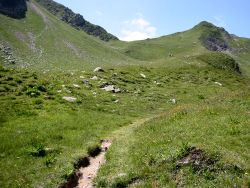
The track soon forks, with a white-and-red marked trail leading straight ahead towards very high-looking rocky terrain! The path climbs steeply through the trees in many switchbacks up the stony, rubbley valley wall, before finally levelling out reaching flower-strewn slopes beside the river. After a steady climb up the left bank, there is a somewhat awkward river crossing and the faint trail leads around to the right, before climbing steeply up the far bank towards the dark rock walls still draped with late snow. It then bends round to the right, around a prominent grassy hillock to Alp Foo after around 1h20. All this stretch is alive with the piercing cries of marmots, although they're often too cautious to be seen.
Shortly the pass appears within sight, just a tantalising few hundred metres higher up. The path continues up across the grassy slopes to the final switchbacks before arriving at the windy pass after around 1h10. The anticipation of the views over the other side of the pass are well-rewarded by a panorama of icy peaks, with the green valley far below. The onward trail leads steeply downhill towards Elm right on the valley floor, and you can see further ahead as the valley forks into two. The next day's stage of the route heads up the right-hand one of these two, leading up to the Richetlipass towards Linthal. The views up here make a highly worthwhile resting stop as you take your last looks back down the Weisstannental.
View up to the first pass of the route, the Foopass
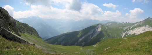
Panoramic view down from the Foopass towards Elm and the peaks beyond
After soaking in the views from the top of the pass, follow the trail signposted Elm, winding steeply down to Raminer Matt in around half an hour. Here you'll find an extremely welcome drinking spout, the first one for quite some time.
The track now heads gently down between the trees again, with views down to the valley and over to the waterfalls cascading off the sheer rock walls opposite. After around 40 minutes you reach Gmeinmad, from which the signposts lead further down to the left towards Elm. This stony track can be steep and loose in places, and requires wooden buttressing in many places to defend the unstable surface against the elements. Eventually the track winds down to meet a road at Stäfeliegg, a further 50 minutes.
Broad track descending through Gmeinmad
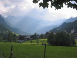
View across Elm fields towards Richetlipass
Follow the road down, still signposted Elm, until a marked footpath drops steeply off to the left. These steps lead down to a path running between the fences, emerging after 20 minutes on the road by Talstation Nideren, the base station of a rather antique cable car that looks more designed for cargo than people. From here there are two signposted routes to Elm, both 15 minutes, so you can choose either the road way, or a footpath following the river, through shady woods and out into the fields on the edge of Elm. If you take this route, you meet the main road of Elm, with the bus stop a short distance to the right.
From Elm you get a clearer view of the fork in the valley ahead, leading up to the Panixerpass and the Richetlipass.
Our next stage will take us over the Richetlipass, the second pass on this long route.
The following are the coordinates for waypoints along this route, obtained from GPS. They can be used either in another GPS, or along with a map, to provide additional references if necessary.
                           Latitude       Longitude    Altitude(m)
       Sargans            N 47°02'43.0    E009°26'42.1     481
       Mels Dorfplatz     N 47°02'50.1    E009°25'10.2     494
       St Martin          N 47°02'49.6    E009°24'48.7     563
       Tschess            N 47°02'24.9    E009°23'22.5    1020
       Hundbüel           N 47°01'58.0    E009°22'54.4     997
       Schwendi           N 47°00'25.6    E009°21'47.7     906
       Weisstannen        N 46°59'20.5    E009°20'34.2    1003
       Vorsiez            N 46°58'40.0    E009°18'10.9    1175
       Barbeque place     N 46°58'10.4    E009°16'29.9    1324
       Walabütz           N 46°58'02.5    E009°16'13.8    1361
       Alp Foo            N 46°56'39.9    E009°15'37.5    1880
       Foopass            N 46°56'34.1    E009°14'17.9    2223
       Raminer Matt       N 46°56'20.1    E009°13'35.8    1897
       Gmeinmad           N 46°55'45.2    E009°12'52.9    1680
       Stafeliegg         N 46°55'17.5    E009°11'42.7    1280
       Nideren cablecar   N 46°55'03.5    E009°11'07.3    1039
       Elm                N 46°55'14.0    E009°10'23.1     970
       Elm bus stop       N 46°55'20.2    E009°10'23.4     962
No prizes for guessing sargans.ch for everything about Sargans, and likewise elm.ch for Elm. For accommodation along the way, heidiland.com has a list of hotels in Sargans, Mels, Weisstannen and Schwendi. The Hotel Gemse in Weisstannen has its own site, as does Alp Siez, both showing details of their accommodation.
Or if you come here in Winter, you can go Snowboarding at Elm instead.