
 |
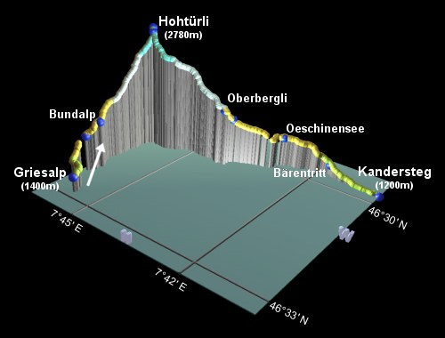
This is the ninth stage of the Alpine Pass Route, crossing from Griesalp over the Hohtürli (the little door), past the Blümlisalphütte and the Oeschinensee down to Kandersteg. It's possible to complete this all in a single day, to overnight in Kandersteg, but this route description takes a break at the Berghaus Oeschinensee to split up the considerable descent and also to give a peaceful evening and breakfast by the tranquil, beautiful lake instead of down in the town. Another way to reduce the legwork would be to take the chairlift down from near the Oeschinensee to Kandersteg, saving your knees about 600m of descent. Or of course you could overnight on the very top in the Blümlisalphütte (at over 2800m!) and watch the sunsets and sunrises before tackling the descent the following day.
The scenery on this stage is spectacular but somewhat bleak, as this pass is the highest on the whole Alpine Pass Route. In stark contrast to some of the grassy saddles earlier on, this is steep, high and wild, exhilarating but daunting.
To get to the start of the walk at Griesalp, there is a steep and scenic postbus ride up the valley from Reichenbach on the Kandersteg to Spiez rail line. Kandersteg itself is a major railway station with trains North to Spiez and South through the Lötschberg tunnel (also carrying cars) to Goppenstein and onwards down to Brig.
From Zürich, there are fast trains to Spiez (sometimes changing in Bern), from where the commuter trains take you on to Reichenbach for the post bus to Griesalp. In total it takes around 3 hours and CHF 36 to the bus stop in Griesalp. Coming back from Kandersteg, there are direct trains to Zürich through Spiez and Bern, taking around 3 hours and CHF 35 (all prices assuming half-price card).
For Griesalp and Bundalp, try griesalp.ch for a small list, or see bundalp.ch for the Berghaus at Bundalp. For a high-altitude overnight, try the Blümlisalphütte, or for the hotel and matratzenlager at Oeschinensee see oeschinensee.ch. For Kandersteg, see kandersteg.ch.
Griesalp - Untere Bundalp - Bundalp - Hohtürli - Obere Bergli - Untere Bergli - Oeschinensee - Kandersteg
Hike time: | 5 hours |
Approx dist: | 10 km |
Start: | Griesalp bus stop |
Finish: | Oeschinensee |
Profile: | from 1400m up to 2800m and down to 1600m |
Rating: | tricky |
In the last stage, after coming over the Sefinenfurgge,
we went past the turnoff to the Hohtürli and continued on to Griesalp for the bus stop. So that means the first part of today's walk will have to come back upriver to this turnoff before continuing up to the pass. In order not to have to retrace our steps, we'll take the opposite side of the river for variety. Those choosing to overnight in Bundalp don't have to do any step-retracing, but do face a bit of a climb straight after coming down from the Sefinenfurgge.
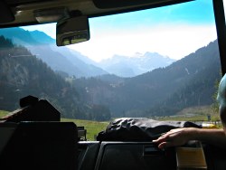
Bus trip up towards Griesalp
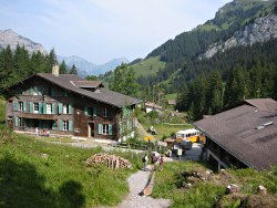
Griesalp
Griesalp
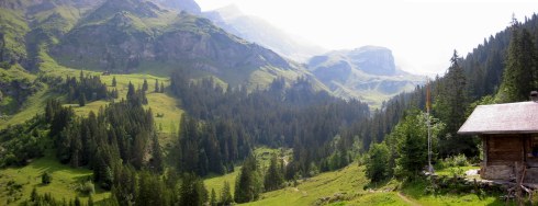
Panorama near Griesalp
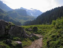
From the bus stop at Griesalp, follow the signs for the Blümlisalphütte and Hohtürli up a path towards the river. Last time we took the path through Golderli and Steinenberg, but this path is more direct and more tranquil, passing through the forest by the stream, to pass just above the junction by the bridge noted last time.
Shortly the path begins to climb in steep switchbacks, reaching Untere Bundalp and then Bundalp, with its restaurant, Matrazenlager and very welcome water spout.
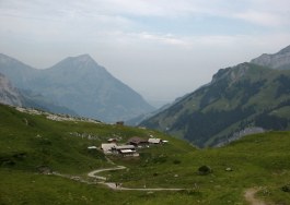
Bundalp and the Niesen
Up towards the snow
Loose ascent
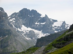
Gspaltenhorn
Looking back down steep ascent
Follow the road uphill from the restaurant and then branch rightwards up a steep path. From here there are great views back down the Kiental valley towards the Niesen and the lowlands beyond, as well as across to the Sefinenfurgge and the craggy Gspaltenhorn.
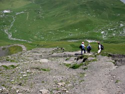
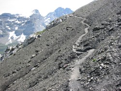
Our path is heading up to the right, though, and becomes very steep as it switchbacks up the loose slope. It splits into a swarm of crisscrossing pathlets as it climbs, with some occasional tricky bits.
Loose traverse
Panoramic views from the ascent
First view of the pass
Steep staircase up to pass
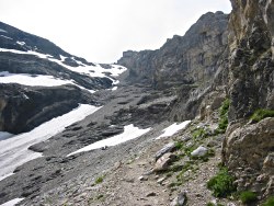
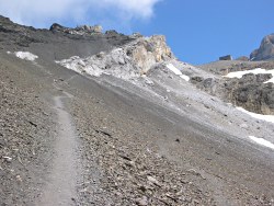
Leaving the greenery behind, the scenery becomes starker and bleaker, with the narrow path traversing the scree. The views back down are truly impressive, but the legs are already feeling the more than 1000m of climb before the pass itself comes into sight.
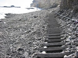
Relentless, the path gets even steeper towards the summit, switchbacking between the rocks and eventually leading to the base of a seemingly endless wooden staircase. This may be wild countryside, but it's Swiss wild countryside, so it has a staircase and a cable handrail.
Needless to say, the views during this exertion are getting ever more dramatic, with snow draping the nearby peaks and parts of this path (in July). Fortunately there is an extremely welcome wooden bench provided for just such view-appreciation, with the Blümlisalphütte in sight to encourage the weary legs.

The panorama from the pass towards Kandersteg
The Hohtürli from the Hütte
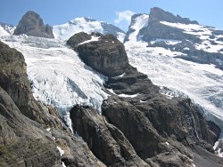
Glacier above the Blümlisalphütte
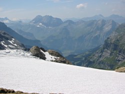
View from the snowy tops towards Kandersteg
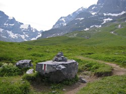
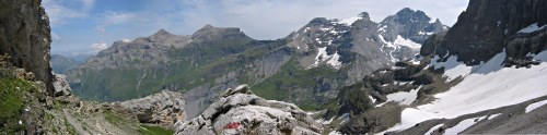
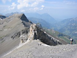
With chocolate duly infused, and the last stretch of staircase wearily conquered, the Hohtürli is finally reached and the hiker is rewarded with an awesome panorama stretching in all directions.
The pass itself is a broad, stony saddle, dominated by the Blümlisalphütte a short distance further uphill. The Blümlisalpgletscher sprawls down from above the hut, and the valley leading down towards Kandersteg is a picture of rugged wilderness. Kandersteg is visible far, far below, with the grassy bowl of Allmenalp hanging above it. Somewhere up there on that ridge is the Bunderchrinde, the next pass on this route. Looking back down the Kiental, the Niesen is also clearly visible, and the Thunersee in the hazy distance.
Bleak view back up to the pass and hut
Glaciers tumbling down from above
Descent through wild terrain
Bleak view back up to the pass and hut
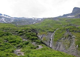
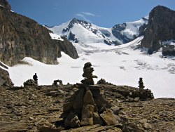
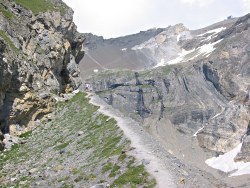
Dropping down on the other side of the pass, the path is steep and the loose stones can be slippy. The narrow path drops down in tight switchbacks across the scree. The awesome glaciers up to the left seem to flow and tumble down over the rocks.
Sidling underneath overhanging rocks and cresting a narrow gravelly ridge, the path continues to lose height through the stark, wild scenery. Shortly however the grassiness returns and after passing through some idyllic cow pastures you reach Ober Bergli where there is a hut offering basic refreshments. Which you may well need after all that exertion.
Panorama towards the Oeschinensee
Path descending above the Oeschinensee
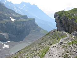
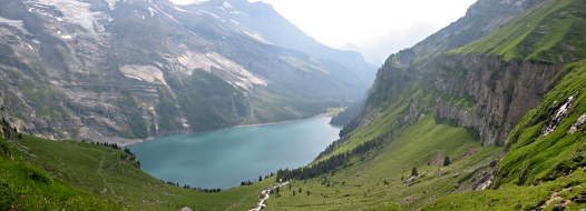
From Ober Bergli the path splits, with a higher path leading round to Heuberg to the right, and our path dropping straight ahead signposted for the Oeschinensee. Here the panorama opens out to reveal the magical Oeschinensee, sparkling and shimmering like a turquoise gem in its rocky clasp.
Another stretch of tricky descent brings you out to a more gentle path above the right-hand edge of the lake, dropping gently to reach the shoreline and an ideal opportunity to reinvigorate those tired feet. The water here comes directly from the melted snow, but swimming is still popular on warm days.
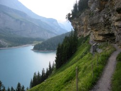
Follow the path around the shore of the lake, past the numerous sculptures and carvings dotted around the woods, to reach the Berghaus Oeschinensee at the far end of the lake. Here you'll find a restaurant overlooking the lake views, and overnight accommodation should you need it.
Hike time: | 1 hour |
Approx dist: | 5 km |
Start: | Oeschinensee |
Finish: | Kandersteg |
Profile: | from 1800m down to 1170m |
Rating: | easy |
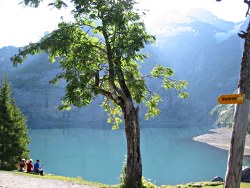
One of the reasons for staying here at the Oeschinensee rather than down at Kandersteg was the ability to spend the evening by this beautiful lake and enjoy the sunrise over the ridge the following morning. So the descent from the Hohtürli is broken up, but the following day will be made a bit longer, because this next short stretch down to Kandersteg has been left as an early morning exercise.
At this point the mechanically-inclined hiker may want to take a detour to the cable car station, a short distance away from the Berghaus Oeschinensee (just follow the signposts).
Morning sunshine on the Oeschinensee
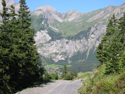
Track down to Kandersteg
Following the signs for Kandersteg, the route follows the road before branching off on a track and then a path, dropping down alongside the stream past Bärentritt to emerge in the fields of Kandersteg. Follow the signs for the station, turning left onto the main road and then shortly right to the railway station.
From here, the next stage of the Alpine Pass Route goes up over the Bunderchrinde to Adelboden.
The following are the coordinates for waypoints along this route, obtained from GPS. They can be used either in another GPS, or along with a map, to provide additional references if necessary.
                           Latitude       Longitude    Altitude(m)
       Griesalp           N 46°32'51.1    E007°45'41.9    1408
       Untere Bundalp     N 46°32'13.9    E007°46'15.2    1690
       Bundalp            N 46°31'59.6    E007°46'07.9    1840
       Hohtürli           N 46°30'39.3    E007°46'13.3    2778
       Blümlisalphütte    N 46°30'36.5    E007°46'17.0    2823
       Oberbergli         N 46°30'31.1    E007°44'04.4    1973
       Unterbergli        N 46°30'21.5    E007°43'58.1    1824
       Bhaus Oeschinensee N 46°29'51.4    E007°42'52.7    1613
       Bärentritt         N 46°29'34.3    E007°41'44.6    1336
       Kandersteg         N 46°29'42.8    E007°40'18.2    1207
For local information, see kiental.ch (now only in German) and kandersteg.ch. There are panoramakarten and 360° views of the Oeschinensee area at oeschinensee.ch.