
Hike time: | 5 hours |
Approx dist: | 13 km |
Start: | Oberbalmberg Kurhaus |
Finish: | Berghaus Obergrenchenberg |
Profile: | Between 1050m and 1440m, |
Rating: | easy - medium |
Greetings: | Grüezi |
This page describes the sixth day of this ridgeway walk, from Oberbalmberg to Obergrenchenberg. This section is relatively short, but offers some of the best panoramas of the mountains of the alps seen so far on this hike. Both Hasenmatt and Stallflue give amazing views on a clear day.
Oberbalmberg has buses to Solothurn, and Untere Grenchenberg (a short distance further on from Obergrenchenberg) has infrequent buses to Grenchen Süd.
You could also combine this hike with a visit to the Seilpark Balmberg, with a large number of rope trails through the trees which you navigate with their rented equipment.
There are a few possibilities for overnighting here, but phone in advance to check the various closing days. Some options include Obergrenchenberg (erlebnisgrenchenberg.ch with basic dormitory or double rooms, phone or email to reserve, also camping possible). Or Untergrenchenberg (untergrenchenberg.ch with single, double and bunk rooms). There's also a tiny wooden sleeping pod by Untergrenchenberg with a sign offering overnight stay with breakfast, but the sign just gives the link tinyveroswiss.ch which appears to be just a way to buy wooden cabins.
Further West
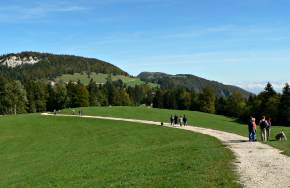
 The easy track from the Weissenstein  Southerly panorama from Hasenmatt towards the Berner Oberland  The ridges ahead to the distant Chasseral |
 |
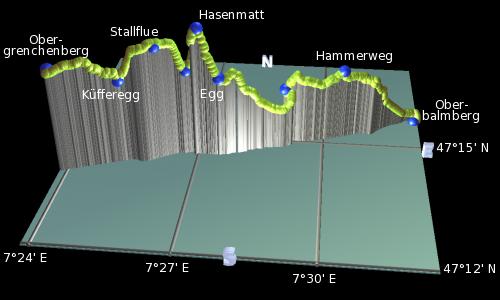
Oberbalmberg - Hintere Weissenstein - Hasenmatt - Stallflue - Küfferegg - Obergrenchenberg
Somewhat surprisingly, the route of the Jura Höhenweg doesn't pass over the summit of the Weissenstein, but goes around it and above the hotel. You could of course follow the Weissenstein hike over the summit instead, and rejoin this route near the Hotel Weissenstein further on. The signposted route for the Höhenweg however leads back up the road from the Kurhaus a short way to the pass, and then left along an easy track with the Röti peak up to the left. There's also a Planetenweg here from the Kurhaus (you can see the yellow Sun from a distance), which you can follow from Mars all the way to Pluto.
The track climbs strongly through the trees, and levels out once more, ignoring the narrow Hammerweg up to the right and remaining on the easy track. Again the track provides great panoramic views over the plain towards the Alps, including the Eiger, Mönch, Jungfrau trio in centre stage. The prominent spike to the left of those is the Finsteraarhorn, followed by the Schreckhorn and then the Wetterhorn. To the right, a host of peaks are lined up all the way to Mont Blanc. Autumn fog makes the panorama even more spectacular.
Following signs for Hasenmatt, the track descends from the junction before climbing up to Egg, where the path splits. We'll ignore the right fork towards Obergrenchenberg, and instead take the uphill path to the left signposted Hasenmatt/Obergrenchenberg. This path climbs to give good open views to the right over the northern ridges, and back towards Hintere Weissenstein and the hotel.
A short climb further brings you to the summit of Hasenmatt, and a real highlight of the Höhenweg so far! The views are massive, with the whole Mittelland laid out before you and the dramatic alpine panorama lined up beyond. Some low-lying fog and some hot air balloons really complete the picture! To the right you can see the three major lakes of Biel, Neuchâtel and Murten, and the ridges outlining the onward route.
Follow the path, descending steeply to the right down to Müren, and then climbing again to the next peak of Stallflue. This gives equally great panoramic views to the south, on an easy, open, flat stretch at around 1400m.
Once again the path descends fairly steeply to the right, dropping to Küfferegg and along the open ridgetop. The distinctive tower on top of the Chasseral comes into view ahead, and also the wind turbine by Obergrenchenberg. Before you reach Obergrenchenberg, there's a spiral wooden sculpture over to the left of the footpath. Take a side trip past this sculpture out to the edge of the ridge, where there's a panorama board identifying all the peaks out in the distance. It's an impressive array, all the way from Säntis and Glärnisch on the left, past the major Berner Oberland peaks, the Breithorn and Altels, Les Diablerets and even Mont Blanc.
From here it's just a short stroll past the cows to the Berghaus at Obergrenchenberg where accommodation and an Erlebnisbauernhof with cafe can be found.
The following are the coordinates for waypoints along this route, obtained from GPS. They can be used either in another GPS, or along with a map, to provide additional references if necessary.
                          Latitude       Longitude      Altitude(m)
     Oberbalmberg        N 47°15'51.0    E007°32'23.3    1058
     Hint Weissenstein   N 47°15'02.8    E007°29'02.8    1226
     Hasenmatt           N 47°14'31.7    E007°27'03.4    1441
     Stallflue           N 47°14'20.9    E007°26'06.8    1400
     Obergrenchenberg    N 47°13'55.8    E007°23'49.2    1357
To view this hike in Google Earth or Google Maps, see the Kmz file for the whole Jura Ridgeway on the main page.
The next section on this hike is Obergrenchenberg to Orvin.