
Hike time: | 7 to 7.5 hours |
Approx dist: | 22 km |
Start: | Vue des Alpes |
Finish: | Noiraigue |
Profile: | Between 730m and 1430m, |
Rating: | medium with short stretches of trickiness, and slippy descent. Long. |
Greetings: | Bonjour |
This page describes the tenth day of this ridgeway walk, from Vue des Alpes to Noiraigue. Two particular highlights are the Tête de Ran and Mont Racine, from where you get massive open views across the flat mittelland to the Berner peaks, including Lac de Neuchâtel spread out below. After Les Tablettes the route bears round to the right and heads towards the Creux du Van, before dropping steeply down to Noiraigue on the valley floor.
Getting to Vue des Alpes is a bit of a pain as the buses from La Chaux de Fonds are very infrequent and unreliable. La Corbatière is about the nearest train station, a few minutes' train ride from La Chaux de Fonds, but beware that it's a request stop, so if you don't know to press the button (and there's no announcement to tell you) then the train just sails right on past to the appetisingly named La Sagne. From La Corbatière it's around 4km to Vue des Alpes, from La Sagne a good 6km of uphill.
Getting back again, La Tourne is a small village with buses to Neuchâtel making it a good stop-off point to make the long hike a bit shorter. Noiraigue has regular trains to Neuchâtel with fast connections.
 Looking ahead to Tête de Ran 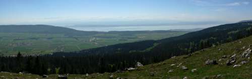 Panorama from summit of Tête de Ran including ridge on left towards Neuchâtel 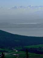 Peaks of Berner Oberland 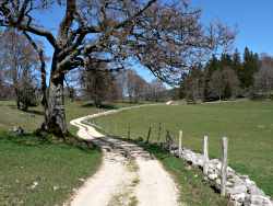 Pleasant track winding towards La Tourne 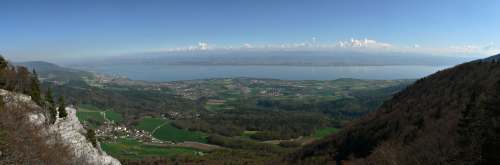 Massive panorama from Les Tablettes including lake Neuchâtel and Berner Oberland |
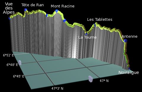 |
Vue des Alpes - Tête de Ran - Mont Racine - La Tourne - Les Tablettes - Noiraigue
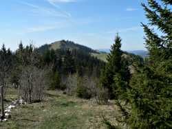
Resuming the hike from Vue des Alpes, don't miss the panorama board across the road showing all the distant peaks. The familiar red and yellow signposts lead across the car park and up alongside the toboggan run (toboggans.ch) up to the ridgetop. The fairly rooty, rocky path undulates along the ridge, after a while leading past scattered chalets to a pair of restaurants below the summit of Tête de Ran. (basic details here). From here you can just make out the tower of Chasseral a long way back.
From the signpost, a track leads onward but a more direct path breaks immediately right marked with red/yellow paint splashes on the rocks. This path zigzags steeply up the hillside climbing 100m to the summit, from where the views south are once again spectacular. Again, the whole of the Berner Oberland is stretched out on the horizon, the enormous snowy peaks impossibly distant beyond the flat green plain and the expansive lake. You can also clearly see the ridge on the left dropping gently from the Chasseral down towards Neuchâtel, which was an alternative route of this ridgeway hike.
Continuing onward, the path drops down the far side of the summit to meet the track from the restaurants - shortcutting the peak is therefore an option but you'd miss the great panoramas from the top. The track leads on along the straight ridgetop clearly visible ahead, with views to both left and right sides. Shortly follows a stunning ridgetop section, on very open, grassy slopes, with views in all directions. This easy stretch has some of the best views on the hike so far, and perfect picnic spots overlooking the lake.
The path leads gently down to Grandes Pradières-Dessus and onward signposted for Mont Racine. This 1440m peak is the highpoint of this day's hike, and rewards the short climb with even more expansive panoramic views both to the south and the north. On the descent, make sure to follow the paint splashes round to the right, through the concrete gateposts and down off the ridge through the trees to Grande Sagneule.
Looking ahead to the lower-looking ridges of hills, the track descends steadily from the farm at Grande Sagneule, before breaking right and left to climb the wooded ridge ahead. This leads to a grassy meadow and a further descent, with a pleasant track winding down to the village of La Tourne. There's not much here apart from a restaurant (closed) and a bus stop, but it does provide a possibility to break up the hike before the next stretch to Noiraigue.
From La Tourne, the path crosses the road and climbs the grassy slope beyond, leading to a rocky path climbing to Les Tablettes. From the lookout point here you get a fantastic, sudden panorama out to the south, again including the lake and plain and the Berner Oberland beyond, but now with a dramatic valley heading rightwards (in which Noiraigue sits) and a thickly-wooded, spinal ridge beyond. One rocky section of this ridge is strikingly similar to the Creux du Van rock walls, just in mini form and not as strongly curved.
From this lookout the path bears round to the right, traversing above the side valley with a steep drop down to the left. The narrow and often very rocky and rooty path climbs and drops along the top of the ridge, occasionally almost becoming invisible before reappearing. With fleeting glimpses through the trees ahead to the real Creux du Van, the path works its way along the ridgetop before beginning the descent, dropping steeply down to a signpost by the tv antennae on a prominent outcrop. From here the track leads relentlessly downward, made trickier with the loose stones and slippy leaves, towards the valley floor and the visible train line.
Zigzagging steeply downwards, it eventually leads across a main road and then down into the village of Noiraigue. The "source" of the black water from which the village gets its name is signposted round to the left and between the houses - a rather underwhelming tourist attraction. However, somewhat surprisingly for a village built around water, every single one of the many fountains built in the village is marked with "no drinking" signs. Following the road round to the right leads straight to the station - and the hourly trains to Neuchâtel.
The following are the coordinates for waypoints along this route, obtained from GPS. They can be used either in another GPS, or along with a map, to provide additional references if necessary.
                          Latitude       Longitude      Altitude(m)
     Vue des Alpes       N 47°04'21.4    E006°52'13.7    1283
     Tête de Ran         N 47°03'15.3    E006°51'12.7    1422
     Pradières-Dessus    N 47°01'53.7    E006°49'35.8    1365
     Mont Racine         N 47°01'17.8    E006°48'58.1    1439
     Grande Sagneule     N 47°00'49.1    E006°48'21.5    1313
     La Tourne           N 46°59'17.2    E006°47'31.3    1129
     Les Tablettes       N 46°58'37.2    E006°47'28.7    1250
     Antenne TV          N 46°57'29.4    E006°44'01.2    1119
     Noiraigue           N 46°57'17.3    E006°43'18.5     733
To view this hike in Google Earth or Google Maps, see the Kmz file for the whole Jura Ridgeway on the main page.
The next section on this hike will continue from Noiraigue to La Combaz, following a similar route to the Creux du Van day hike.