
Hike time: | 5.5 to 6 hours |
Approx dist: | 18 km |
Start: | Berghaus Obergrenchenberg |
Finish: | Orvin bus stop |
Profile: | Between 550m and 1380m, |
Rating: | easy - medium |
Greetings: | Grüezi / Bonjour |
This page describes the seventh day of this ridgeway walk, from Obergrenchenberg to Orvin. It includes quite a bit of downhill, and some people may prefer to break it up at Frinvillier instead of Orvin.
Untere Grenchenberg has infrequent buses to Grenchen Süd, and both Frinvillier and Orvin have bus connections to nearby Biel/Bienne.
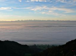 Early morning fog over the Mittelland 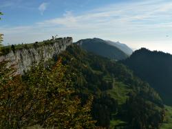 Sheer ridges by Obergrenchenberg 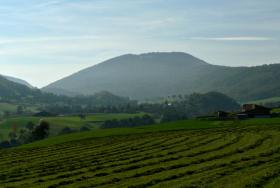 Lowland greenery towards Orvin |
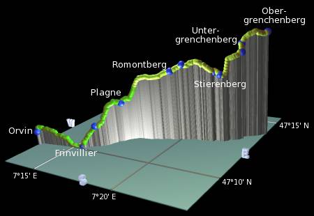 |
Obergrenchenberg - Untergrenchenberg - Stierenberg - Romontberg - Plagne - Frintillier - Orvin
There is another couple of great lookouts on the ridgetop near Obergrenchenberg, signposted off to the left of the path. One is right on the edge of the cliff looking south, and the other ("Durchblick in die Urzeit") shows the side of the cliff and how it was formed.
The path continues, signposted for Untergrenchenberg, dropping gently across the fields with open views ahead towards the Chasseral. Shortly it reaches Untergrenchenberg, where the restaurant offers accommodation and a superbly located terrace for meals. From here a path takes a shortcut down to meet the road again, from where a track leads on to Zimmerboden. A short distance further on at Obere Fuchsberg a so-called Chäsweg leads through the trees to meet a track to Stierenberg, where there's another restaurant. Like Untergrenchenberg, this restaurant is also closed on Mondays and Tuesdays.
Follow the road to Wäsmeli and the track to the left with glimpses over to the left and ahead towards the Chasseral. Shortly the path emerges in the open at Pâturage de la Montagne, and for the first time the signposts don't say "Höhenweg" but instead "Chemin des crêtes". Which means that even before half-way on this hike, we're reaching the fuzzy language border and the place names and hellos are going to be more and more French from now on.
The pleasant, easy track continues with intermittent southward views through Romontberg (Montagne de Romont) with its simple café and on through the wood past the many painfully quaint little Swiss chalets. Suddenly the path breaks left steeply downhill, and the neighbouring ridge to the left begins to block the panoramas of the alps. Saying goodbye to the big mountains, the path continues to descend over open hillsides, and past the attractive restaurant au vieux Grinier down into the small village of Plagne.
Pass through the pleasant, sleepy village, and back out into open fields once more. The ridge still blocks southerly views, but the path drops down even further, becomes a narrow, overgrown roadside trail for a short while, before crossing the road and meeting a second road shortly before the bus stop called "Bifurcation". From here a track leads to the right, becoming a path and then emerging to sudden road noise above Frinvillier.
Cutting through the maze of concrete flyovers and tunnels, follow the road past Taubenloch train station, and endure the rather unpleasant stretch of path directly beside the main road leading away from Frinvillier. Fortunately a track soon forks up to the right, climbing through the trees to give views ahead to Orvin and the sheer ridge soaring up to the right. Follow the path along the base of this ridge to eventually reach the bus stop at Sous les Roches, just above the village of Orvin. To divert down to the village itself and its bus connections to Biel, continue ahead to the next road junction, where signposts lead left down the lanes to the village square.
The following are the coordinates for waypoints along this route, obtained from GPS. They can be used either in another GPS, or along with a map, to provide additional references if necessary.
                          Latitude       Longitude      Altitude(m)
     Obergrenchenberg    N 47°13'55.8    E007°23'49.2    1357
     Untergrenchenberg   N 47°13'18.0    E007°22'51.1    1295
     Stierenberg         N 47°12'38.2    E007°22'06.8    1086
     Romontberg          N 47°12'06.7    E007°19'38.7    1119
     Plagne              N 47°11'16.9    E007°17'10.0     879
     Frinvillier         N 47°10'09.1    E007°15'30.4     555
     Orvin               N 47°09'38.7    E007°12'50.3     669
To view this hike in Google Earth or Google Maps, see the Kmz file for the whole Jura Ridgeway on the main page.
The next section on this hike is Orvin to Chasseral.