
Hike time: | 6.5 hours |
Approx dist: | 20 km |
Start: | St Cergue |
Finish: | Borex |
Profile: | Between 470m and 1680m, |
Rating: | easy to medium, with exposed climb |
Greetings: | Bonjour |
This page describes the seventeenth and final day of the Jura ridgeway walk, from St Cergue up to the summit of la Dôle and turning sharp left down to Borex. The obvious highlight to this day is la Dôle, with spectacular views south to the French Alps including the prominent Mont Blanc, and north to forested ridges.
It's quite a long day though, and in particular there's a lot of descent. The signposts even appear to continue beyond Borex to Nyon, for those who like their Höhenwegs low and flat.
St Cergue has a train station with regular connections to Nyon. Borex has buses to Nyon.
For accommodation in the centre of St Cergue, see the previous day's description. For the Chalet le Coutzet a bit further out (N 46°26'52.8, E006°08'02.7, 1144m), follow these directions to "La St Cergue" and then follow the road to the right until you see the sign for "le Coutzet" up to the left.
 Climbing up from Le Vuarne  Summit in sight 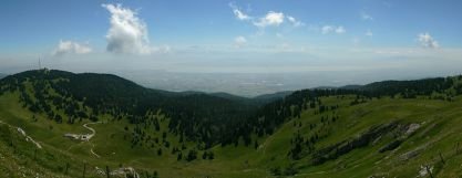 Panorama from the summit of La Dôle 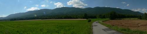 Looking back at the Jura ridge with La Dôle in the middle |
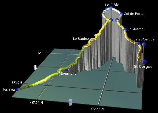 |
St Cergue - La St-Cergue - Route du Vuarne - Le Vuarne - Col du Vuarne - Col de Porte - La Dôle - Chalet la Dôle - Le Bauloz - Bonmont - Borex
From the station at St Cergue, the village centre is just a few hundred metres further on, following the Jura signs to the right past the cafe to the main roundabout. Or to stay at Chalet le Coutzet it's another 3km, just follow these directions to "La St-Cergue" and then take the road to the right.
From the roundabout in St Cergue, follow the signposts straight ahead and then right along the lane by the tennis courts. This road winds along below the main Nyon road to Le Chenalette, and continues straight ahead. Shortly a path forks left and climbs between the chalets, reaching a signpost at "La St-Cergue". From here the Chalet le Coutzet is just 5 minutes along the road to the right. A small signpost marks the gravelly track up to the chalet itself.
Our path continues from La St-Cergue, taking the road to the left up to the Refuge de la Barillette at l'Archette. This refuge is another possibility for spending the night, but only if you have your own tent.
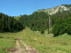
The path leads straight up the grassy slope alongside the telephone wires, heading towards the metal antenna, which is a lower peak to the left of our goal. When the path meets the small road, follow it to the right to Route du Vuarne. Here the rock faces ahead look considerably wilder than the gentle countryside previously.
The lane continues straight ahead to Le Vuarne, with occasional glimpses of the golf-ball on top of La Dôle. A track leaves up to the left, continuing the climb, opening out views of the forests behind. At Col du Vuarne, you emerge on the grassy plateau, with the first views of the wide bowl and steep cliffs under the summit of La Dôle. The Chalet (or buvette) is only 10 minutes away from this col and a little lower, but our route will take us far round to the right, climbing up along the ridgetop to reach the summit, before looping round and back down to the chalet.
The climb gets a little steeper now, and needs a steady footing on the narrow path. As the path curves around, the panoramas open up to the left, with more spectacular contrasts between idyllic flatland, tranquil lakes and distant harsh icy mountains. When you reach the summit and the multiple "golf balls" (actually radar dishes for air traffic control and weather measurements), you'll be greeted by panoramas in all directions, many picnickers and—as with almost everywhere on the route today—very inquisitive cows.
So that's the highest, and last, summit on this ridgeway walk. From here it's effectively all downhill, as the route cuts back down to the chalet and down the side of the ridge to Borex down on the plain below. Which is odd, because as you can clearly see ahead, the Jura ridge continues on into France with a clear ridgeline snaking into the distance. But the waymarking is done by a Swiss organisation so this is where the route breaks sharply left just before the French border.
To France: Those who wish to brave the journey into the EU would be advised to get some good maps with the hiking trails marked on, as the helpful Jura signs won't be there to guide you. All I can tell you is that the path drops fairly steeply from the summit of La Dôle to Petit Sonnaille (N 46°24'44.9, E006°04'58.6, 1390m) and the surprisingly empty border. Then a track leads through the woods to La Cabosse (N 46°24'12.1, E006°04'37.6, 1385m) and is signposted in the direction of Col de Faucille. After that it looks like the targets would be Colomby de Gex and then Crêt de la Neige (the highest peak of the Jura).
But to complete our Jura ridgeway walk, we continue to follow our "5" signs from the summit of La Dôle, continuing briefly to the southwest before turning left at the signpost to begin our long descent off the ridge. The path curves gradually round to the left as it drops, eventually heading almost straight for the previous col de Vuarne, and negotiates a small rise before arriving at the chalet de la Dôle (open, but favouring light salads rather than energy-giving substance).
From the chalet we follow the road downhill, before rooty paths and tracks bring us more swiftly downhill. With countless switchbacks and different surfaces, we make it down to La Bauloz, where amazingly there are not just picnic tables and benches, but even a water fountain without "non potable" written on it! Gasp. Drinking water has been surprisingly rare round here, for Swiss standards.
Continue the descent on the road towards Bonmont, making a few leisurely switchbacks before taking the narrow path plunging down to the right of a hairpin. This slippy, stony path makes lots of switchbacks as it hurtles down the side of the ridge, but unfortunately the views beyond the thick trees are rare. After around an hour, the paths, tracks and lanes bring you to the signpost at Bonmont.
With just a little more roadway descent, you finally break out of the trees to low farmland, and can look back up at the ridge. La Dôle is obvious directly above, and it's also obvious that the ridge stretches in both directions. The contrast from crops and sunflowers to sheer wooded ridges is also clear, as you try to imagine the scale of it.
Once out on the flat road, it's a more or less straight southeasterly push towars Borex, between the dense crop fields with the whole landscape flat for miles. After a little left-right jink round a farm, it's just straight ahead to the tiny crossroads in Borex where the bus to Nyon stops (Note: not at the post office a short way further on).
There should be a congratulations sign or something at the end of this hike, but there isn't. Instead, the sign at this bus stop indicates that the number "5" route continues to Nyon, but after the 1200m+ descent the legs might need a rest by Borex. As it is, this bus stop at Borex is a fairly arbitrary ending point for the 17 days' walking, which is maybe why they've extended it to Lac Léman for a more satisfying goal point. But as mentioned earlier, perhaps a continuation into France would make more sense?....
The following are the coordinates for waypoints along this route, obtained from GPS. They can be used either in another GPS, or along with a map, to provide additional references if necessary.
                          Latitude       Longitude      Altitude(m)
     St Cergue Gare      N 46°26'55.2    E006°09'35.9    1046
     La St-Cergue        N 46°26'41.5    E006°08'03.0    1149
     Route du Vuarne     N 46°26'14.8    E006°07'50.2    1269
     Le Vuarne           N 46°26'10.1    E006°07'09.0    1319
     Col du Vuarne       N 46°25'49.1    E006°06'38.1    1469
     Col de Porte        N 46°25'57.2    E006°06'12.9    1556
     La Dôle             N 46°25'32.2    E006°06'00.0    1676
     Chalet la Dôle      N 46°25'33.9    E006°06'27.6    1446
     Le Bauloz           N 46°24'56.3    E006°07'40.2    1137
     Bonmont             N 46°24'06.5    E006°08'45.0     605
     Borex               N 46°22'43.0    E006°10'39.0     469
To view this hike in Google Earth or Google Maps, see the Kmz file for the whole Jura Ridgeway on the main page.