
Hike time: | 6 to 6.5 hours |
Approx dist: | 24 km |
Start: | Brugg station |
Finish: | Salhöhe bus stop |
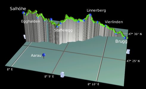
Profile: | Between 350m and 810m, |
Rating: | easy but long |
Greetings: | Grüezi |
This page describes the second day of this ridgeway walk, from Brugg to Salhöhe. It makes quite a long day all in one go, so those wanting a shorter section may prefer to use Staffelegg as a convenient stopping point.
Brugg is connected to Zürich with regular, direct trains, while Staffelegg and Salhöhe have buses to Aarau.
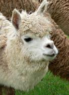
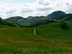
 Local resident  Open views by Chillholz  Hilly scenery on the way to Staffelegg |
 |
Brugg - Riniken/Umiken - Vierlinden - Linn - Chillholz - Staffelegg - Bänkerjoch - Egghalden - Salhöhe
From the front of Brugg main station, the signposts lead across the main road and along the pedestrianised but concretey shopping street. It soon reaches the much more attractive old part of town though, and if you bypassed Brugg station by taking the more direct route along the river, this is where the signposts merge again. Cross the river and bear left up the road, following the red-flashed signposts up a track. This soon reaches a picnic spot high above the town.
Shortly the path forks, with both ways signposted for the Höhenweg. We'll take the left fork, signposted for Linn and Staffelegg, which cuts through the trees on a narrow path. This becomes a track, climbing past sheep and llamas with views back towards the Gebenstorfer Horn beyond Brugg. The ridge of Lägeren from day 1 also begins to rise into view beyond that.
After passing a Riniken signpost (confusingly some way south of the actual centre of Riniken), a wide flat track gives open views out along the river Aare towards Aarau, charting our general direction. Then the track dives between the trees again, before converging with, and crossing, a major road. Follow the track on the other side back into thick forest to Widacher, where the Höhenweg again splits.
Continue straight ahead to Linn, a few minutes further on, and head out to meet the road. Turn left and follow the road — there's no footpath but the right-hand shoulder is just about wide enough. Shortly you can leave the road to the left and climb the track alongside the field, reaching open views to the north, over the nearby hills and beyond to flatter Germany.
Climb up to the Linnerberg, from where you get good open views, before dropping back down through the trees to Möseren. Coming through Chillholz you get a panorama from the open saddle, before another forested stretch to Staffelegg car park. This is a regrouping zone for the motorbikers, set outside and above Staffelegg itself. To get there we have to follow the road, again without a separate footpath, curving round and dropping to the restaurant and bus stop.
From Staffelegg, follow the road past the bus stop and then climb the steep track up to Herzberg. Continue to Bänkerjoch, which also has a bus service to Aarau if you want to break here. Or continue along the track to Egghalden, take a left up around the field of sheep and then a quick right on a path up through the trees. This steep, stepped path climbs up to a narrow ridge, and if you were to turn left here you'd come to the lookout point of Wasserfluh, with the big tv mast seen earlier. But we're turning right and following the narrow and rocky ridge, before dropping back down another stepped path to meet the road again at Cholwald. (If you had wanted to skip the up and down of the ridge there's a flatter and quicker route along this road back to Egghalden.) From here there's a path leading along the slope with open views to the right, leading past a schiihütte (!) to reach Salhöhe bus stop. From here there are hourly buses to Aarau.
The following are the coordinates for waypoints along this route, obtained from GPS. They can be used either in another GPS, or along with a map, to provide additional references if necessary.
                          Latitude       Longitude      Altitude(m)
     Brugg station       N 47°28'51.6    E008°12'32.6     349
     Riniken/Umiken      N 47°29'03.7    E008°11'11.8     393
     Vierlinden          N 47°28'49.0    E008°09'33.0     514
     Widacher            N 47°28'34.9    E008°08'21.0     572
     Linn                N 47°28'14.7    E008°07'57.9     580
     Linnerberg          N 47°27'47.0    E008°07'28.3     722
     Möseren             N 47°27'16.2    E008°06'45.5     665
     Chillholz           N 47°27'08.6    E008°06'02.2     649
     Staffelegg          N 47°26'01.4    E008°03'38.1     621
     Herzberg            N 47°26'10.2    E008°02'43.4     697
     Bänkerjoch          N 47°26'12.6    E008°01'46.8     668
     Egghalden           N 47°25'56.5    E008°00'55.1     720
     Cholwald            N 47°25'44.0    E007°59'36.0     762
     Salhöhe             N 47°25'42.3    E007°59'14.1     779
To view this hike in Google Earth or Google Maps, see the Kmz file for the whole Jura Ridgeway on the main page. Thanks to Amy for pointing out the Riniken/Umiken confusion.
The next section on this hike is Salhöhe to Allerheiligenberg.