
|
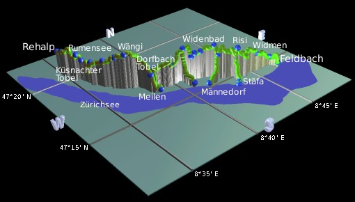
Running down the eastern side of the Zürichsee (the opposite side from the Uetliberg), the 28km Zürichsee Panoramaweg enjoys elevated views over the lake on very easy footpaths. The route was opened in August 2005 and is for the most part excellently signposted. It's suitable for short there-and-back trips from the many car parking opportunities, and also for longer trips using the bus and S-bahn services along the route. The route starts in Rehalp, at the end of the number 11 tram network of Zürich, and passes above Zollikon, Küsnacht, Erlenbach, Herrliberg, Meilen, Männedorf and Stäfa, dropping down to finish at Bahnhof Feldbach. For a detailed map see the pdf link below.
The paths are a mixture of roads, tracks and footpaths, and is generally very easy. There are just a few short sets of steps to contend with, and the signposting is excellent.
The start of the walk is at Zürich Rehalp, which is a minor tram station on the southeast edge of the city network. It can be easily reached with the number 11 tram (from the Hauptbahnhof, through Bellevue) or with the Forchbahn (from outside Stadelhofen station). Because it's in zone 10, you can get there with any normal city ticket.
Getting to and from the other stations along the route is easy thanks to the regular S-bahns along the lake shore. Meilen, Uetikon, Männedorf and Stäfa all have good connections back to Zürich and don't lie far from the walk route. There are several bus stops along the way too, many of them directly on the route itself. You can just get single tickets to return, or if you already have a Zürich ticket then an Anschlussbillette (extension ticket) for the right number of zones is probably cheaper.
There are also boat connections between from Erlenbach, Herrliberg, Meilen, Uetikon, Männedorf, Stäfa and Uerikon, connecting to Zürich Bürkliplatz and places on the opposite coast of the lake like Wädenswil and Horgen. This makes an interesting way to finish off the day, and with the ZVV extension tickets is surprisingly cheap.
For a zoomable, scrollable map of this hike, see this online map using Openstreetmap or Opencyclemap.
You can also download this kmz file zuerichsee_panoramaweg.kmz to open it in programs like Google Earth or GpsPrune and then transfer the track to your GPS.
 Panoramic view from the Zürichsee panoramaweg at Zolliker Allmend 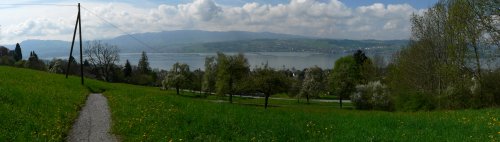 Another Zürichsee panorama from near Stäfa 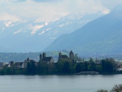 View of Rapperswil across the Zürichsee |
Zürich Rehalp - Zolliker Allmend - Rumensee - Schübelweier- Küsnacht Allmend - Erlenbach Allmend - Biswind - Wängi - Luft - Burg - Zur Au - Uetikon Brand - Stötzli - Binziger - Appisberg - Widenbad - Risi - Widmen - Langenriet - Feldbach
The whole panoramaweg is really too long to walk in one go, but you can choose whether to split it into two, three or more days depending on your keenness. For a two-day trip, Uetikon am See would be a good place to aim for, and for a three day trip you could perhaps break at Meilen and Männedorf. Or of course you can just choose a short section to walk, rather than trying to do the whole thing.
 |
From Rehalp tram stop, follow the 'panoramaweg' signposts down a side-road to the right, past clusters of modern, blocky housing units. Shortly a path diverts through a wood and past the outdoor pools at Fohrbach, then passes under the main road to reach Zolliker Allmend. Here there's a small car park, a bus stop, and most importantly the first views of the Zürichsee and the Uetliberg ridge.
As the path follows the grassy ridge you get great views to the right of the snow-covered Glärnisch range above Einsiedeln, the whole Albis ridge round to Uetliberg Kulm and even the tip of Rigi peeking out if it's a clear day. This whole open slope is a paradise for dogs and their owners, and popular with strollers and walkers alike. Curving left away from the lake, the path then turns right into the forest, and is marked intermittently with yellow arrows and diamonds on the trees. Carefully follow these past the picnic area, over the bridge, across the Rumenseeweg and out to the small lake of Rumensee. If you emerge instead by a pyramidal wooden church, you're too high, head right and downhill to the Rumensee.
Follow the side of this small lake, past the barbecue areas, picnic tables and frisbee golf baskets, cross the main road and follow the path out onto a second road. Turn left by the second lake of Schübelweier, following its shore and admiring the many fish within. Shortly after leaving the lake, the path takes a sudden and dramatic turn into the surprisingly impressive Küsnachter Tobel (the name 'Tobel' means a steep V-shaped gorge). Steep steps lead the intrepid swiftly down into the heart of this deep stream valley, where you'll find a bridge over the stream, a waterfall nearby, and a matching set of rather steep steps leading back out of the Tobel on the other side.
The path then passes alongside a set of Swiss allotments into the residential area of Küsnacht Allmend, leading past fruit orchards, past streams and across fields, before climbing up to a superb lookout by Erlenbach Allmend. There's a stretch of extraordinarily expensive houses and villas squabbling for the best lake views, but the best panoramas are from the constantly changing footpath. These continue through Biswind and Wängi with expansive views of snowy and not-so-snowy peaks beyond the lake, until the path descends down to Luft on the way towards Meilen.
For those ending the day's walk at Meilen, the road here leads directly down towards the town, and at the bottom the signposts will direct you to the station just a few minutes' walk away. For those continuing on the panoramaweg, the route takes a path through the Dorbachtobel (another Tobel), following the side of the steep valley to reach Burg. Unfortunately in April 2006 this Dorfbachtobel path is closed due to a large amount of fallen trees blocking and damaging the way. So the best way to continue is to follow the road down towards Meilen, and cut back up left on the stepped footpath up to meet the path again just below Burg.
From Burg the path leads around another panoramic stretch parallel to the lake, before dropping down a steep set of steps to the bus stop at Zur Au. Watch out, these steps can be tricky when covered in snow! After a short stretch of streamside path, and several more lake-viewing opportunities, a footpath leaves to the right for those wishing to break at Uetikon am See. From here it's about half an hour downhill through vineyards to the S-bahn station. For those staying on the panoramaweg it's just a little further to Uetikon Brand. Continue past Bergheim and the residential areas on the edge of Uetikon, past the scouting installations and out onto another enjoyable panoramic stretch with benches for the weary legs. The route then goes through a play area and barbecue area, before dropping down between fruit trees back towards the lake. Here is another opportunity to break the route, with a short diversion to Männedorf. This village has two very visible church spires, one squareish on the right and one roundish on the left. The rail station is below the squarer one and easy to find.
Back on the trail above Männedorf, the signposts lead onwards, on a flattish path through cultivated land with a mix of views and intermittent panoramas ahead towards Stäfa. Crossing a road, it takes a short but sharp climb up a track around the shoulder of a hillock to pass above a vineyard. This track shortly becomes a narrow path which enters the wood. A series of steps lead past a surprising waterfall tucked away between the trees, although this isn't the whole story - it's actually only about the top third of the waterfall, the bigger drop is below tumbling down towards Stäfa. For those wanting to break at Stäfa for the S-bahn or boat stations, just take the stepped path down the stream and follow the arrows through the village.
Continuing past the waterfall, the path climbs up to reach the lookout at Risi, with an open view of the lake, a set
of benches and even open fireplaces for barbeques. A perfect spot for a picnic. Continuing onwards, follow the track
down to meet the road, follow this road leftwards for a short way before turning right past the tennis courts and
football pitches. Loop around the field of Christmas trees, past more vegetable farms, and down a squelchy path to
Widmen. Here the route loses height gradually and the views become flatter rather than looking down on the lake.
Pass more farms and fields to Langenriet, before dropping down to gain open views towards Rapperswil. The track
leads directly to the S-bahn station at Feldbach and the end of this panoramaweg. Cross the bridge for
the Zürich trains which leave from platform 2.
The following are the coordinates for waypoints along this route, obtained from GPS. They can be used either in another GPS, or along with a map, to provide additional references if necessary.
                           Latitude       Longitude    Altitude(m)
        Rehalp            N 47°21'03.1    E008°34'59.8     522
        Zolliker Allmend  N 47°20'38.3    E008°35'02.9     535
        Rumensee          N 47°19'45.3    E008°35'27.4     542
        Schübelweier      N 47°19'28.5    E008°35'36.3     520
        Küsnacht Allmend  N 47°18'56.9    E008°35'50.8     524
        Erlenbach Allmend N 47°18'22.4    E008°36'17.9     544
        Biswind           N 47°17'52.0    E008°36'46.1     571
        Wängi             N 47°17'32.2    E008°37'13.7     586
        Luft              N 47°16'30.6    E008°38'11.6     500
        Meilen            N 47°16'12.4    E008°38'38.7     425
        Burg              N 47°16'43.5    E008°38'37.2     511
        Zur Au            N 47°16'23.7    E008°39'42.8     515
        Uetikon am See    N 47°15'33.0    E008°40'45.0     429
        Uetikon Brand     N 47°16'23.4    E008°40'48.0     575
        Binziger          N 47°16'06.5    E008°41'29.2     546
        Appisberg         N 47°15'58.1    E008°41'50.2     553
        Stötzli           N 47°16'10.3    E008°41'15.9     531
        Männedorf         N 47°15'11.3    E008°41'35.8     421
        Ober Allenberg    N 47°15'22.5    E008°42'37.8     540
        Risi              N 47°14'55.2    E008°43'47.6     562
        Stäfa stn         N 47°14'26.8    E008°43'19.2     414
        Widmen            N 47°14'47.6    E008°45'23.6     501
        Langenriet        N 47°14'43.2    E008°46'40.6     451
        Feldbach station  N 47°14'20.6    E008°46'59.7     426
A description of the route in German is available at zpp.ch with a very detailed map in pdf format available for download (see link 'Panoramaweg Karte').