
| |||||||||||||||
| Day 1: | |||||||||||||||
| |||||||||||||||
| Day 2: | |||||||||||||||
|
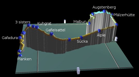
The Liechtensteiner Panoramaweg is officially described as a 3-day hike from Malbun to Ruggell and describes a fish-hook shape with a significant amount of ridge-top adventure. The panorama views are excellent, high over the Rheintal, and the narrow, steep paths are spectacularly impressive. But beware - these paths are rather tricky in places and you need to have a reasonable head for heights and steady feet. If you're happy using ladders and support cables then this one is an experience.
This hike also provides an opportunity to see something of Liechtenstein, and marvel at how such a tiny land can avoid being assimilated by its bigger neighbours. You're never far from the Austrian border, even following it in some stretches, and the border to Switzerland is the Rhein just down in the valley.
Although the official version continues downhill to Ruggell (probably staying overnight at Sücka and the Gafadurahütte), we will skip the last day and finish at Planken instead. This has two advantages - firstly it can then be squeezed into a rewarding two-day weekend trip, and secondly it reduces the amount of descent.
The signposting is excellent, using the symbols for route 66, "Liechtensteiner Panoramaweg". If you're phoning somewhere to reserve or for information, don't forget you need the international dialling code, 0042 for Liechtenstein.

For a zoomable, scrollable map of this hike, see this online map using Openstreetmap or Opencyclemap.
You can also download this kmz file liechtenstein_panoramaweg.kmz to open it in programs like Google Earth or GpsPrune and then transfer the track to your GPS.
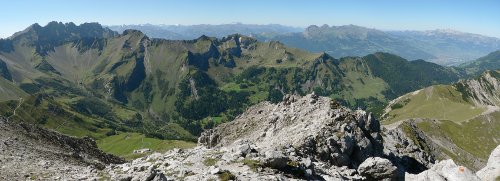
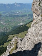
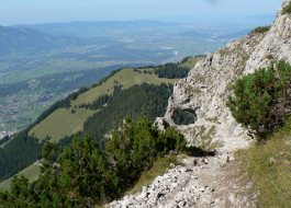
 Panorama from Augstenberg  View down into the Rheintal  Descent from the 3 sisters |
The start of the walk is Malbun, a small ski resort tucked into a bowl in a side valley. This is most conveniently reached by bus from Vaduz which in turn has bus connections to Switzerland. This version of the walk ends at Planken, which has hourly buses to Schaan (LI), which again has buses to Switzerland. Note that the last bus from Planken is currently 17:53,
If you want to make the hike a little shorter, one option is to take the chairlift from Malbun up to Sareis at 2010m and join the route on the ridgetop. Or if you want to cut it even shorter down to a one-day hike, you can use the bus stop at Steg, on the Vaduz to Malbun bus route, which is in the valley below Sücka.
From Zurich, there are regular connections to Malbun and from Planken, both via Sargans and both taking around 2 hours.
 |
Malbun - Sareiserjoch - Augstenberg - Pfälzerhuette - Aelple - Sücka
The bus stop "Malbun Zentrum" is at the end of the bus line, and makes a convenient starting point regardless of whether you want to take the chairlift up or not. For the upward hike you just need to backtrack along the main road around 300m to the Jöraboda bus stop (and thereby see a little of Malbun), from where the signposted track leads uphill to the East. Already from here you can see the ridge up to the right and the cross at the top of the Augstenberg.
The broad track climbs steadily up to the right, and passes underneath the chairlift cables. Faint paths cut uphill to the left, but you might as well stay on the main track, which eventually makes a switchback back towards the upper chairlift station. Before it gets there, however, a path zigzags up to the right, climbing to the ridgetop at Sareiserjoch. From here you can not only see across the Rheintal to the Säntis massif, but also down into the valley to the East across Nenzinger Himmel.
The ridge curves round to the right, and the path follows it around, continuing to climb steadily up to the Augstenberg. This summit makes a popular lunch stop and a chance to soak in the views in all directions. The Schesaplana is visible, but not stunningly dominant, and the Naafkopf rises to the west. The Rheintal is clearly visible below, as well as the obvious ridge curving round to the distant Drei Schwestern.
From today's high point, the path then heads downhill to the south, on a narrow path (tricky in places) to the Pfälzerhütte. This well-positioned hut can be spectacularly popular at weekends, with a big patio area and plenty of refreshments for the hikers.
From the Pfälzerhütte, the signposted route takes the track down into the valley to the right, but immediately takes a path down to the left, heading for the far side of the valley. The path swiftly loses altitude through marmot country, continuing left to ignore a fork down to Steg.
Continuing northwards, the valley deepens to a narrow chasm below, and the walls above climb higher. Beyond Älple, you approach the buildings and reservoir of Steg far below, and the entrance to the side valley towards Malbun on the right. There then remains just a gentle descent to Sücka's Berggasthaus, which is actually more or less directly above the road tunnel through which our morning bus brought us to Malbun.
The accommodation at Sücka Berggasthaus (suecka.li) is pleasant, clean and good value at CHF 30 for the Matratzenlager. Toilets, washrooms and shower rooms are on the same floor. Evening meal is another CHF 30 for "halbpension" (fixed two-course meal) but choosing from the regular menu is also possible and may be a better option.
Sücka - Silum - Gafleisattel - Kuhgrat - Garsellakopf - 3Schwestern - Sarojasattel - Planken Schulhaus
From Sücka, the signposts lead up the road ahead, before cutting left through a short tunnel and following the side of the expansive Rheintal. These panoramas are spectacular, reaching southwards to Pizol, Sargans and the entrance to the Walensee valley; westwards to the Alvier range and the whole Säntis / Hoher Kasten range; also northwards to the Bodensee, Pfänder and of course the Drei Schwestern ahead.
A couple of kilometres past Silum, the ridge takes on a much steeper, rougher character, and the footpath has to struggle across the sheer, crumbling face. A head for heights is essential on this spectacular stretch called the Fürstensteig, all the way up to the Gafleisattel.
This now brings you out on to the long ridge leading to the three sisters. Firstly you pass underneath the summit of the Gafleispitz, and then up to the Kuhgrat which makes a good lunch spot with really 360 degree views. Then there's a bit of a descent before a tricky climb up to the small rocky summit of Garsellakopf.
From here there's just one peak left to conquer, and that's the three sisters itself. From here it's not obvious why it's called three sisters, because only one main peak is visible. And it's a little lower than the Garsellakopf, so the approach from this side is relatively straightforward and not too tricky. The only problem is finding a space to sit on the top, as it's a tiny rocky summit and the only way over is to scramble past the other hikers and down the other side.
If the final approach to the Drei Schwestern was straightforward, the descent to the north down to Prafazei is anything but. It's a spectacular, steep, tricky and strenuous hike down, with two long metal ladders being essential on the steep rock.
Below Sarojasattel, the path zigzags down through the trees, steadily losing altitude to the Gafadurahütte. Here is another ideal stop for a rest and some refreshment with views over the Rheintal. It's also a good time to check the bus times from Planken, should you need them, as they're only every hour and finish early. From the Gafadurahütte it's around 1h15 (at a comfortable pace) remaining to Planken, but you can do it in less if you hurry. Alternatively, this Hütte can make an overnight stop if you want to stretch out the route to three days (see gafadurahuette.li).
There is a broad track down from the Gafadurahütte to Planken, but the red-and-white markings lead you on paths shortcutting the switchbacks. Some of these paths are a bit slippy and rooty, but a lot faster than taking the track. Shortly you'll emerge onto the residential roads of Planken, and will be led straight to the bus stop at Planken Schulhaus. The official route continues downhill to the right towards Ruggell, but we stop here and take the bus to Schaan at the end of a very satisfying hike.
The following are the coordinates for waypoints along this route, obtained from GPS. They can be used either in another GPS, or along with a map, to provide additional references if necessary.
                           Latitude       Longitude    Altitude(m)
        Malbun            N 47°06'03.0    E009°36'36.8    1620
        Sareiserjoch      N 47°05'40.4    E009°37'31.6    2000
        Augstenberg       N 47°04'56.9    E009°36'36.3    2347
        Pfälzerhütte      N 47°04'16.4    E009°36'47.7    2093
        Aelple            N 47°05'35.8    E009°34'33.6    1620
        Sücka             N 47°06'54.8    E009°33'53.2    1415
        Silum             N 47°07'52.2    E009°33'17.7    1469
        Gafleisattel      N 47°09'03.6    E009°33'10.6    1840
        Kuhgrat           N 47°09'59.6    E009°33'39.0    2107
        Garsellakopf      N 47°10'13.0    E009°33'52.5    2100
        3Schwestern       N 47°10'32.0    E009°34'22.9    2052
        Sarojasattel      N 47°10'57.8    E009°34'25.1    1625
        Gafadurahütte     N 47°11'10.0    E009°34'06.2    1440
        Bei Blockhütte    N 47°11'12.5    E009°33'11.8    927
        Planken           N 47°11'09.5    E009°32'47.3    795
        Schulhaus         N 47°11'08.7    E009°32'45.2    790
There is some good information at tourismus.li, and more at the official wanderland.ch. There's also a brief description of the whole Panoramaweg in German at wandersite.ch.