
Hike time: | 4.5 to 5 hours |
Approx dist: | 12 km |
Start: | Pico do Facho bus stop |
Finish: | Porto da Cruz |
Profile: | from 200m up to 350m, and down to sea level |
Rating: | Mostly easy paths apart from short narrow/steep bits along cliffs |
Boca do Risco means "dangerous pass", and is a lookout point high above the coast in the northeast of Madeira. This hike starts off by following a flat levada before climbing up to the Boca do Risco, and then traversing the cliffside to the west. It finishes by dropping to the coast at Porto da Cruz, after a very varied and exhilarating hike.
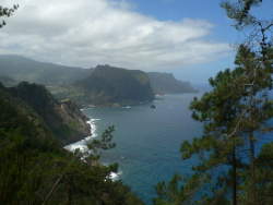
 View over Machico including Pico do Facho  Steep, Madeiran coastline  View ahead towards Porto da Cruz and Eagle's Rock |
This hike is one of the few which make good use of the public transport system on Madeira. This makes it possible to do a linear walk rather than retracing steps to the start. There are buses between Machico and Caniçal (number 113) which stop (at request) at the turnoff to Pico do Facho which is the start of the walk. There are also buses between Porto da Cruz, where the walk ends, and Machico (buses 53 and 78).
If you have a rented car, it is quite easy to park it at Machico and take the bus to the start of the walk, and at the end of the walk to take the bus back to Machico. However the bus times are irregular and it is definitely advisable to find out the bus times in advance to avoid long waits.
This kmz file (4 kb) contains waypoints from this Boca do Risco hike and shows the path as a red line along the trail. Simply open it in Google Earth (File -> Open) and you'll see the route in full. Press the "Play Tour" button below the listed waypoints and you can fly a tour along the hike in 3d.
Pico Facho bus stop - Boca do Risco - Porto da Cruz
 |
From the bus stop on the main road to Caniçal, a side road leads off to the right signposted to Pico do Facho. Opposite this turnoff, on the north side of the main road (on the left facing Caniçal), you will find the levada do Caniçal running alongside the houses a little way back from the road.
Turn left along the levada and follow its winding path away from the road to the west and north. It leads away from the houses and gardens (but sadly not away from the rubbish of food tins and beer bottles in the levada) and gives views over the Machico valley including Pico do Facho with its transmitter mast.
After a little less than an hour on the levada, a signposted path leads right uphill towards Boca do Risco. The good path climbs through the pine and eucalyptus forest, and through a particularly fire-damaged valley, up to the Boca do Risco.
From the top of the pass at 350m you get great views over the ocean and the windswept clifftops stretching in both directions. To the left, you can see the clear path ahead carved into the cliffs.
We follow this narrow path westwards along the cliffs, admiring the open views and the feeling of remoteness. It's not far from the settlement we started from but it feels very remote, with just trees, blackberry bushes and Aeonium flowers for company. And the other hikers of course. There's a steep drop to the sea but the path is not dangerous at all, there are just a few very short stretches where some care is required. There aren't many good places for a picnic though, so keep on the lookout.
Eventually our destination Porto da Cruz slides into view with its dramatic "Eagle rock" beyond. Shortly thereafter the path meets a track and starts to descend, becoming a wide concrete road by the cable car station. This cable car isn't for passengers, it's just for transporting goods to and from the boat stage below.
Follow the road down and as it gets steeper, there's a spot where the road bends left, there's a driveway on the right, and a set of steps lead straight ahead down from the driveway. Take these steps, and follow the path round the left-hand side of the earth hill, keeping left and dropping down to meet another road. Here, jink right-left to cross a stream and then follow the path along the stony beach to Porto da Cruz.
As you approach the church, turn left to reach the main street, where you'll find a small bus shelter. The bus to Machico stops on the other side of the road from the bus shelter.
The following are the coordinates for waypoints along this route, obtained from GPS. They can be used either in another GPS, or along with a map, to provide additional references if necessary.
                           Latitude       Longitude    Altitude(m)
       Pico Facho busstop N 32°43'58.2    W016°45'52.7     208
       Path Boca do Risco N 32°44'46.3    W016°46'23.9     221
       Fiery valley       N 32°45'08.8    W016°46'11.3     294
       Boca do Risco      N 32°45'20.0    W016°46'20.1     356
       Steep bit          N 32°45'30.0    W016°47'13.5     335
       Track              N 32°45'40.7    W016°48'06.8     328
       Cable car          N 32°45'41.1    W016°48'19.3     305
       Porto da Cruz bus  N 32°46'18.3    W016°49'44.4      42