
Hike time: | 3.5 to 4 hours |
Approx dist: | 10 km |
Start: | Bar at Fontes |
Finish: | Bar at Fontes |
Profile: | from 940m up to 1430m, and back again |
Rating: | Easy tracks but plenty of climb and very dusty |
This loop walk climbs up to the summit of Achada da Pinta, high above the Ribiera Brava valley. As well as the valley views you get spectacular views of the higher peaks in the centre of the island around Encumeada.
It's worth bringing plenty of liquid on this hike as it can get hot and the tracks can get very dusty. There are no refreshments en route except for the small bar at the start and end of the walk.
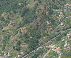 Looking down at the terraces of the Ribiera Brava 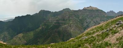 Mountain scenery during the climb  Barren and rugged |
The walk starts and ends at Fontes, by the only bar in the small village high above the Ribiera Brava valley. Simply park your hire car on the main road as close to the bar as possible.
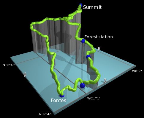
This kmz file (4 kb) contains waypoints from this Achada da Pinta hike and shows the path as a red line around the loop. Simply open it in Google Earth (File -> Open) and you'll see the route in full. Press the "Play Tour" button below the listed waypoints and you can fly a tour along the hike in 3d.
Fontes - Achada da Pinta - forest station - Fontes
 |
From beside the bar in Fontes, take the track leading straight ahead northwards climbing gently away from the village. Very shortly, you're in the countryside and the track climbs steadily away from civilization.
The track offers several viewpoints over the deep valley to the left and the ocean beyond, the tiny buildings and terraced slopes far below, the built-up area of Ribiera Brava itself squeezed into the mouth of the valley, and round to the head of the valley at Encumeada and the surrounding peaks.
The track continues to climb but swings round to the right, with a few switchbacks along the ridgetop to eventually reach a track junction. We'll return to this junction for the descent, after we've made our trip to the summit and back. We continue then up the track and between the cows, following the well-worn trail to the unmarked summit. There are great panoramas from here if the weather is clear. The only things spoiling this ideal picnic spot are the shortage of places to sit and the surplus of flying insects.
One unusual novelty on this hike is the sight of minibus tourists, making the final brave assault of the peak by foot but only after sitting in a 4wd jeep all the way to within the last 50 metres. Then after the successful conquering of the summit, the patiently-waiting driver herds them back in and rumbles back down the trail again. I guess that's another way to the top of this peak, and certainly faster than walking all the way...
Retracing our steps back down the track to the junction, we take the left turn here and follow the track down past the forest station to emerge eventually on a concrete road. This in turn leads down to reach the main road, where we turn right and return to Fontes. In the bar, some well-earned chilled drinks are waiting after the dusty descent!
The following are the coordinates for waypoints along this route, obtained from GPS. They can be used either in another
GPS, or along with a map, to provide additional references if necessary.
                           Latitude       Longitude    Altitude(m)
       Bar Fontes         N 32°42'07.4    W017°01'14.6     940
       Summit             N 32°42'58.0    W017°00'06.7    1435
       Forest station     N 32°42'27.6    W017°00'33.5    1180
       Concrete road      N 32°42'16.0    W017°00'40.6    1092
       Main road          N 32°42'06.0    W017°00'57.3     960