
Hike time: | 4.5 to 5 hours |
Approx dist: | 12 km |
Start: | Pen-y-Pass |
Finish: | Pen-y-Pass |
Profile: | from 360m up to 1085m, and back again |
Rating: | Easy-medium trails but plenty of climb |
Snowdon is a very famous mountain in Britain, being the highest mountain in Wales and higher than any of the English peaks. It gives its name to the whole Snowdonia national park, even though it's actually called "Yr Wyddfa" in the local Welsh language. It's also one of the few British mountains reachable by mountain railway (since the late 1800s!) so even the not-so-hardy can enjoy the views from the top.
This has the bonus that there is a cafe and restaurant at the top (or at least, there will be once it's all opened in May/June 2009), but the downside that there are large numbers of people at the top, especially on sunny weekends. Note that at the time of writing the building work for the new cafe looks complete but it's not open yet and there are no toilets or refreshments available, and little shelter. The train is also not yet able to reach the summit until the track work is complete, so if you do want to get the train down you'll have to walk down to the next station.
Don't let the modest height of 1085m deceive you though, this isn't a hilltop stroll, it's a real mountain and can be very dangerous if the weather turns sour. Which it can.
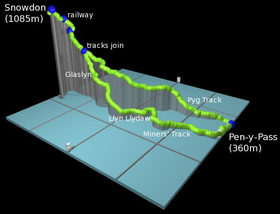
There are several different walking routes to the top, with the most popular being the two used here (the Pyg track and the Miners' track), the Watkin path and the Llanberis path (just following the railway). More scarily there's also the so-called "Snowdon horseshoe" route along a terrifying exposed ridgetop from Crib Goch round to Y Lliwedd. All these and more options are all outlined in the Wikipedia page linked below.
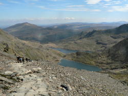 Pyg track above Glaslyn and Llyn Llydaw  Welsh coastline from the summit of Snowdon 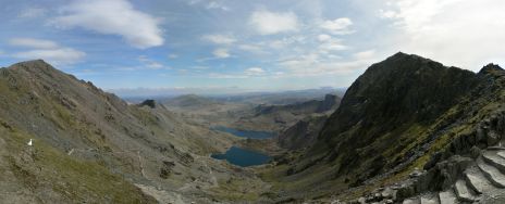 Two ridges of the horseshoe and the lakes below 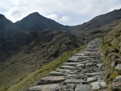 Miners' track with Snowdon summit upper left |
The walk starts and ends at the car park at Pen-y-pass. There is a limited amount of parking (4 GBP per day) if you get there early. You can also get a bus to here from Llanberis or other nearby towns.
This kmz file (12 kb) contains waypoints from this Snowdon hike and shows the path as a red line around the loop. Simply open it in Google Earth (File -> Open) and you'll see the route in full. Press the "Play Tour" button below the listed waypoints and you can fly a tour along the hike in 3d.
If you haven't got Google Earth installed, you can see the same file in a program like GpsPrune instead.
Pen-y-pass - Pyg track - railway - Snowdon - railway - Miners' track - Pen-y-pass
 |
and down the Miners' track |
Two lakes dominate the scenery on this hike - the larger Llyn Llydaw and the higher Glaslyn. On the ascent you look down on the two lakes to the left, but the return journey drops down to pass right by both lake shores. They not only provide excellent orientation markers but also soften the harsh landscape immensely. A big advantage of this route is that the starting point Pen-y-Pass is already fairly high (at 360m) so this reduces the climb and descent. Plus these two routes provide a convenient way to make a loop walk without having to return the same way down.
From the car park at Pen-y-pass, the Pyg track leaves from the far right-hand corner of the car park, behind the cafe. There's a noticeboard with information about the track and the mountain. Surprisingly this is the last signpost you'll see though.
The track starts out well paved and climbs steadily towards the west, giving open views down the valley towards Llanberis and its lake. There are plenty of opportunities for photos as you gain height and Pen-y-Pass disappears round the corner. The landscape is fairly bleak but there are occasional sheep watching the hikers pass by. Clear ahead is the steep peak of Crib Goch, but at the start of the walk the summit of Snowdon is hidden from view.
Once you reach around 560m altitude, the path clears the top of a ridge and you get a sudden, open view over the lake of Llyn Llydaw and the Miners' track far below. Up ahead the final goal of the Snowdon summit is now clear and you can see the path climbing ahead towards the ridgetop.
At around 760m you reach the first upright marker stone, where the Miners' track climbs to join the Pyg track from the left, and the way continues ahead up towards the skyline. From here you can clearly see the pointed summit of Snowdon up to the left, probably already swarming with hikers.
At around 900m the slope gets steeper and the path, which was heading straight towards the ridgetop, has to break sharply right while the slope is restrained into walls by mesh. After a couple of switchbacks the path climbs up to reach the ridgetop at just short of 1000m, and the vista opens gloriously over the far side to include the coastline of Wales and the island of Anglesey. Here there is a second upright marker stone as the path joins the Llanberis path towards the summit, and the slope on this side is dominated by the single track cog railway from Llanberis.
From here to the summit is only another 600 metres or so, but the path gets much busier as all the paths combine to head for the summit. Impressively, the much-hyped new restaurant building on the summit blends in extremely well and is almost unnoticeable until you're right on top of it. The use of grey granite and the necessarily strong walls make it look more like a bunker than a souvenir shop, but it's sunk into the side of the mountain at the end of the railway track and looks stylish without detracting from the scenery. At the time of writing this isn't open yet but it should be opened in either May or June 2009.
After soaking in the 360° panorama from the summit, the way back down requires retracing your steps alongside the railway back down to the marker stone, and turning right down the steep path used on the ascent. Follow this all the way down to the first marker stone above Glaslyn, and now turn right, taking the rather steep path down towards the lake. The dark face of Snowdon looks very intimidating from here! The path is also different here, steeper and made of rather large and awkward boulders. It looks like climbing the Miners' track is more strenuous than the Pyg track way.
Past the shore of Glaslyn, the track continues down to Llyn Llydaw, where it flattens out considerably and turns into a lakeside stroll. You pass by some abandoned mine buildings and a rather incongruous pipeline leading to a hydroelectric plant, before rounding the corner past a smaller lake. The view opens out to include the valley east of Pen-y-Pass, and the greenery of the lowlands contrasts sharply with the more barren vegetation higher up. There are also interesting quartz veins running through the rocks, like layers in a sandwich.
The final stretch of the walk just descends gently round the corner and heads north back to the car park. There's one more signpost about the Miners' track with some history, and you can get refreshments and an all-important toilet break back at the cafe.
The following are the coordinates for waypoints along this route, obtained from GPS. There aren't many signposts or markers on this hike, just the finger stones where the tracks join and split.
                           Latitude       Longitude    Altitude(m)
       Pen-y-Pass         N 53°04'49.7    W004°01'14.9     360
       Fingerstone1       N 53°04'22.0    W004°04'13.8     763
       Fingerstone2       N 53°04'21.8    W004°04'46.5     994
       Snowdon            N 53°04'06.5    W004°04'34.4    1085
Both the Pyg track and the Miners' track, as well as other paths like the Watkin path and the Llanberis path, are marked on Openstreetmap, so if you want to extract Openstreetmap data and transfer it to your GPS receiver (as described in the GPS maps section), you'll have all the paths you need marked already.
See Wikipedia's page on Snowdon for more information, including separate pages on Crib Goch, Llyn Llydaw and the Snowdon mountain railway. Or of course if you can read Welsh, then see Wicipedia's page on Yr Wyddfa. For information about the summit and the new building on the top (called "Hafod Eryri"), see snowdon-summit.co.uk.
One excellent description of this hike on the Pyg track and Miners' track is at walkingbritain.co.uk including a simple sketch map. Or there's another description of a variety of routes (including this one, number 5) at hightrek.co.uk.
For another mountain hike in the Snowdonia area, see Cader Idris.