
Hike time: | 4.5 to 5 hours |
Approx dist: | 9.5 km |
Start: | Minffordd |
Finish: | Minffordd |
Profile: | from 100m up to 900m, and back again |
Rating: | Easy-medium climb, tricky and loose descent in places |
Sometimes, one can get too hung up on a name. Is it "Cader Idris" or "Cadair Idris"? Is it the seat of a giant, the stronghold of a warrior king, or a mountain lair of a dragon? Is there a connection to Arthur's Seat in Edinburgh? The more you read, the less you know. It's a shame because everyone wants it to be a powerful, Welsh name steeped in legend.
So let's forget the name and concentrate on the mountain. Starting the climb through low woodland, the highlight of this loop is a dramatic glacial cwm or corrie, scooped out of the rock with a tranquil lake of Llyn Cau hidden inside. Following the ridge around this cwm, the views are spectacularly panoramic, all the way to the sea from the very prominent summits.
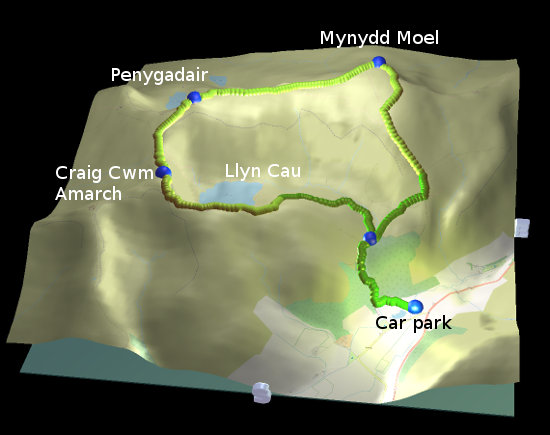
"Summits" in plural because this particular variant covers three peaks: firstly Craig Cwm Amarch on the west side of the cwm, then up to the main summit of Penygadair, and finally the optional third peak of Mynydd Moel.
 Looking down to the lake of Cwm Cau 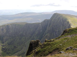 The sheer cliffs of Craig Cwm Amarch 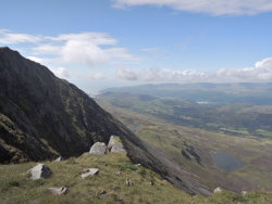 Northwestwards, towards the sea 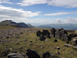 Mynydd Moel 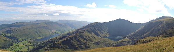 From the descent, towards Tal-y-llyn (left) and Cwm Cau (right) |
The walk starts and ends at the car park at Minffordd. Just off the main A487 road near the Gwesty Minffordd is a dedicated car park with pay-and-display machines. There's also a tea shop (tŷ te) about 100m along the path from the car park, although watch out for its closing times.
There appears to be a bus stop right next to the car park too, which appears to be on the bus route between Dolgellau and Tywyn past Tal-y-llyn. Note however that the train station called "Minffordd" is in completely the wrong Minffordd, you want to be south of Dolgellau, not east of Porthmadog!
This kmz file (4 kb) contains waypoints from this hike and shows the path as a red line around the loop. Simply open it in Google Earth (File -> Open) and you'll see the route in full. Press the "Play Tour" button below the listed waypoints and you can fly a tour along the hike in 3d.
If you haven't got Google Earth installed, you can see the same file in a program like GpsPrune instead.
Minffordd - little bridge - Craig Cwm Amarch - Penygadair - Mynydd Moel - little bridge - Minffordd
 |
the ridge above the lake |
This route makes a clockwise loop around the spectacular bowl of Cwm Cau, taking in the scenery from all its angles. It does make an optional detour to Mynydd Moel, so if you want to make it a bit shorter (but not much) then you can cut off that corner and take a shortcut.
From the car park at Minffordd, the signposts lead you from the noticeboard on level paths past the tea house. Just afterwards, a right turn through a gate takes you to the beginning of the stepped climb through the forest. The stream on the right is going to accompany the hiker for some time. After about 1km you come to a path junction leading to a stone bridge — after all the three summits have been explored, the return route will come down across this bridge and back down to the tea house. For the upward route we keep left.
Shortly, our path bends further leftwards and westwards, still climbing steadily. It takes quite a while for the cwm and lake to come into view though, as our route climbs leftwards. (Note at this point that there are paths going directly to the lake, so if you just want to walk around the little lake and explore inside the cwm, you can. However the onward path to the west climbs very steeply up the cliff, so if you're heading towards Penygadair then you probably want to climb up around the cwm, not go into it.) The summit of Penygadair is visible on the north side of the scoop, but still looks a long way away.
Eventually the path climbs up and around to the first (and lowest) of our summits, Craig Cwm Amarch. From here you get precipitous views down to the blue lake, and it makes a good first sandwich stop. From here the path drops over 50 metres (requiring some care over the uneven surface) before beginning the ascent smoothly once again towards Penygadair. On the way up, you can look rightwards back across to Craig Cwm Amarch and admire the sheer cliffs.
Just below the summit of Penygadair, the Minffordd Path approaches the Pony Path coming from the left, and here the route becomes rather unclear. Some faint trails cut across early to the Pony Path, and some straggle round to the right behind the rocks. But either way, you'll soon join the clearer path and the stone pillar at the summit becomes the obvious target.
From here, you can see all the way to the see, with the train bridge to Barmouth clearly visible. The views are in all directions though, and it's interesting how little of the visible scenery is manmade (like motorways, buildings, walls, power lines etc). As far as the eye can see, it's almost completely hills, rocks, forests and lakes. And the occasional sheep.
The onward path leads straight across the grassy summit, gently descending towards the third, bare peak of Mynydd Moel. (Does Mynydd Moel mean 'bare mountain'?) Shortly you get to decide whether to fork rightwards on the shorter route, or keep straight on and make one more summit. It's an easy upwards stretch to Mynydd Moel though, only interrupted briefly by a ladder over a wire fence, and well rewarded with views in all directions, as well as some interesting rocks to clamber over.
From here it's all downhill, the most straightforward option is to return to the wire fence and just follow it down the fall line of the hill. The other option is to leave the summit to the southeast, and follow the faint path as it curves down rightwards to meet the other paths. It's a straightforward path but difficult to follow in places, then perhaps some dead-reckoning over the grass might be necessary.
This is where the tricky bit of the descent begins. The path becomes steep, and becomes covered in loose stones. Quite some care is required on the heavily-eroded terrain in order to keep one's balance, so those who don't like steep or slippy descents won't enjoy this section. But soon the tricky bit ends, the path becomes grassy again, and the views open up to see Cwm Cau from the other side, and the lake of Tal-y-llyn.
Now it's just a steady, straightforward descent to the stone bridge and the path junction passed earlier, then down the steps through the forest, past the tŷ te and back to the car park.
The following are approximate coordinates for waypoints along this route. There are sufficient signposts along the way to prevent getting lost, apart from on the summit of Mynydd Moel.
                           Latitude       Longitude    Altitude(m)
       Minffordd          N 52°41'12.7    W003°52'39.2     100
       junction           N 52°41'29.4    W003°53'02.0     300
       Craig Cwm          N 52°41'31.3    W003°54'35.8     760
       Penygadair         N 52°41'59.2    W003°54'31.3     890
       Mynydd Moel        N 52°42'20.7    W003°53'05.8     850
All the paths here are marked on Openstreetmap, so if you want to extract Openstreetmap data and transfer it to your GPS receiver (as described in the GPS maps section), you'll have all the paths you need marked already.
See Wikipedia's page on Cader Idris for more information, and of course Snowdonia for the surroundings. Or there's Visit Snowdonia and there's also a description of this "Minffordd Path" hike at TrekkingBritain.
For another mountain hike in the Snowdonia area, see Snowdon.