
Hike time: | 5.5 to 6 hours |
Approx dist: | 18 km |
Start: | Noiraigue |
Finish: | La Combaz |
Profile: | Between 730m and 1460m, |
Rating: | medium with a sharp initial ascent which can be slippy. |
Greetings: | Bonjour |
This page describes the eleventh day of this ridgeway walk, from Noiraigue to La Combaz. It is essentially the same as the Creux du Van day hike, only in reverse and in this case only going as far as La Combaz. The main highlight of this stage is of course the Creux du Van, the amazing circle of cliffs which comes as the reward for the steep climb up from Noiraigue. Strangely absent from this day of the Jura ridgeway are the expansive panoramas towards the Berner Oberland - here the only such views are from Le Soliat (weather permitting), after this point the path proceeds through woodland and country scenery, but without the distant vistas.
Getting to Noiraigue is easy thanks to the regular train service from Neuchâtel. If you finish the day's hike at La Combaz, there are buses to Couvet, which lies on the same train line as Noiraigue from Neuchâtel. A short distance before La Combaz is another bus stop called Les Rochats which is however quite a long way from the restaurant with the same name. Cafe opportunities are provided at Les Oueillons, La Baronne, Les Rochats and at the end of the walk at La Combaz.
 Narrow footpath up from Noiraigue 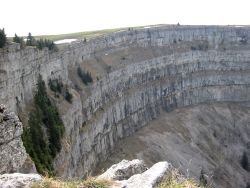 The spectacular cliff walls of the Creux du Van 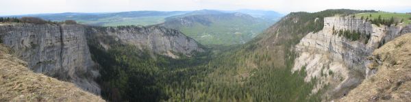 This amazing cirque just won't fit in the viewfinder 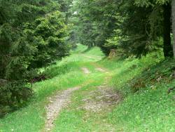 Track through trees near La Baronne 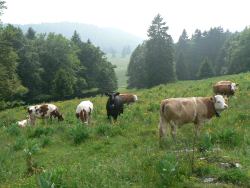 Friendly cows near La Combaz |
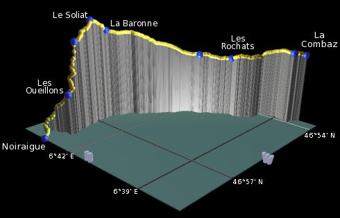 |
Noiraigue - Les Oeuillons - Creux du Van - Le Soliat - La Baronne - Les Rochats - La Combaz
In the approach to Noiraigue, you get a good view of the Creux du Van, so you'll already have a pretty good idea of which way the path will go. From the train station at Noiraigue, follow the signposts along the road and bear right across the train tracks to begin the climb. The road shortly becomes a pleasant, wide track climbing gently through the trees, reaching the cafe at Les Oueillons after around three quarters of an hour. On our visit the cafe was closed but the menagerie outside gave us an enthusastic welcome.
From Les Oueillons, the path gets narrower, and steeper, and in places a bit slippy. It zigzags up the slope offering views back northwards down to Noiraigue, before reaching a cliff edge at around 1350m. This gives the first close-up views of what the Creux du Van cliffs look like, but they get even more spectacular from here as the path climbs more gently in the open.
The path roughly follows the edge, either side of the stone wall, and offers some amazingly vertiginous photo opportunities. Or, if you're unlucky with the weather, thick white fog and rain gusting upwards from the roaring cauldron... but either way the edge of this fantastic cirque is the high point of the day's hike and one of the most memorable points on this whole route so far.
From the cliff edge it's just a short climb further up the grassy hill to the very summit, from where (if the weather allows) you get the long-awaited views southwards towards the Alps. Or more clouds! The path then leads down the other side, with red and white splashes marking the way down to La Baronne, where there is a welcoming restaurant.
The broad track leading away from La Baronne bends round leisurely to the right, descending gradually and meandering through the trees and colourful meadows. The track eventually leads out onto a quiet road, flanked by odd clumps of trees and tended by contented cows.
The familiar red/yellow signposts lead then off to the right, crossing the fields and entering the wood. A novelty feature here is a walled-off area to the right of the path, which looks completely pointless until you go through and see the gaping chasm in the rocks within- so presumably the walls are there to guard against stray animals (and people).
Shortly the path emerges from the trees by a road, and a welcome picnic bench, a short distance from the restaurant at Les Rochats. From here, again follow the signposts climbing up to the right, passing through idyllic countryside scenery. As the path climbs suddenly across a grassy slope, you get a rare glimpse over the trees to distant hills behind you to the east. The route then becomes a meandering track once again, climbing gently to meet the road at the bus stop just before La Combaz. Note that although the name of this bus stop is "Les Rochats", it's a good hour's walk from the restaurant with the same name. La Combaz itself is just a short stretch further on down the road to the left, which has a restaurant as well as another bus stop. Both of these bus stops are served by the same route to Couvet.
The following are the coordinates for waypoints along this route, obtained from GPS. They can be used either in another GPS, or along with a map, to provide additional references if necessary.
                          Latitude       Longitude      Altitude(m)
     Noiraigue           N 46°57'17.3    E006°43'18.5     733
     Les Oeuillons       N 46°56'45.0    E006°43'02.2    1014
     Le Soliat           N 46°55'53.1    E006°43'20.4    1463
     La Baronne          N 46°55'28.0    E006°43'19.6    1376
     Les Rochats         N 46°53'22.2    E006°40'23.2    1164
     bus stop            N 46°52'51.0    E006°38'27.1    1247
     La Combaz           N 46°52'33.3    E006°38'14.6    1223
To view this hike in Google Earth or Google Maps, see the Kmz file for the whole Jura Ridgeway on the main page.
The next section on this hike continues over the Chasseron from La Combaz to Sainte Croix.