
Madeira is a small volcanic island in the atlantic ocean, north of the Canary islands. It's most famous for its remoteness, its Madeira wine, and its varied hiking opportunities, especially along the myriad of impressive levadas.
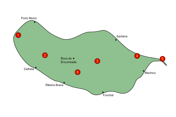
Here's a map of Madeira showing (roughly) where the hikes are. Click on the numbers, or use the summary below.
For a zoomable guide to all the Madeira hikes, whether half-day strolls or multi-day treks, see this Google Earth file: ![]() Madeira hikes kmz. It shows the rough location of each of the hikes, and the accompanying bubbles contain links back to the hike descriptions here at the Activity Workshop.
Madeira hikes kmz. It shows the rough location of each of the hikes, and the accompanying bubbles contain links back to the hike descriptions here at the Activity Workshop.
Note that for the island of Madeira, Google Maps is not particularly useful as it has almost no detail whatsoever apart from the coastline. Far better are the free Openstreetmaps.
| Name | Summary | ||||
1
|
Cabo | A scenic loop walk in the far west of the island, with a mix of tracks, village roads and levadas. |
|||
2
|
Rabaçal | Exploration of some of the many levada paths by Rabaçal. |
|||
3
|
Pico Ruivo | Spectacular and adventurous hike from Pico Arieiro to Pico Ruivo (the highest peak on the island) and back. |
|||
4
|
Boca do Risco | From urban levada above Machico over a ridgetop to remote cliffside path along the coast to Porto Cruz. |
|||
5
|
Ponta de São Lourenço | Endless coastal views from the very easternmost tip of the island. |
|||
6
|
Achada da Pinta | A loop walk on dusty tracks high above the Ribeira Brava valley. |
Please note that all times and prices are approximate, and may be subject to change since the hikes were researched. On many of these walks there is the danger of falling rocks and blocked paths - these are often swiftly marked as such and repair work is undertaken when possible. Take note of these signs as the damaged sections can be dangerous. Also watch out for rapidly changing weather conditions and be prepared to turn back if necessary.
The ![]() icon means that a GPS was used to record the hike, and so waypoints
and 3d plots are available. The
icon means that a GPS was used to record the hike, and so waypoints
and 3d plots are available. The ![]() icon means that photos are
available. For these Madeiran hikes there are also Kmz files provided, which you can open in programs like Google Earth or GpsPrune to show the routes - these are indicated by the
icon means that photos are
available. For these Madeiran hikes there are also Kmz files provided, which you can open in programs like Google Earth or GpsPrune to show the routes - these are indicated by the ![]() icon.
icon.
Also, please feel free to share your experiences. Any additional information, corrections, suggestions and comments would be gratefully received by email - all due credit will be given.
Some wikipedia links: Madeira, Levada. Also wikitravel has an article on Madeira and a Portuguese phrasebook.
If you can read German, you might also try the German wikipedia which has slightly more information.