
Hike time: | 5 hours |
Approx dist: | 15 km |
Start: | Allerheiligenberg Klinik |
Finish: | Balsthal station |
Profile: | Between 500m and 1000m, |
Rating: | easy - medium |
Greetings: | Grüezi |
This page describes the fourth day of this ridgeway walk, from Allerheiligenberg to Balsthal. This is not too long a day's hike, but has a fair bit of descent, especially in the final section down to Balsthal.
Allerheiligenberg has buses to Olten, and Balsthal has regional trains shuttling to and from Oensingen on the main express line.
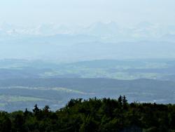 Struggling to see the distant Alps 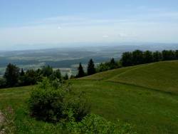 Open ridgetop looking south from Schlosshöchi 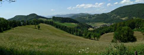 Rolling ridges by Schlosshöchi 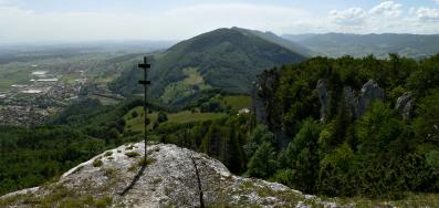 View westwards from Roggenflue |
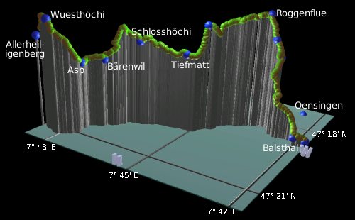 |
Allerheiligenberg - Wuesthöchi - Bärenwil - Schlosshöchi - Tiefmatt - Roggenflue - Balsthal
Because we took a slight detour from Wueshöchi down to Allerheiligenberg to get the bus, the first part of day 4 is retracing the steps to resume the Höhenweg. This isn't far, but starts off with a 100m ascent through the trees back to the meadow at Wuesthöchi.
From here the signposts lead leftwards down the grassy slope towards Asp and Bärenwil. Following a path through the trees, and then a track continuing downhill, the route then takes a signposted path steeply down to the right, taking a strangely neglected, overgrown track down to meet a stream. This pleasant stream-side stretch leads along to Asp and the curving track leads on to Bärenwil with its restaurant and water spout.
From Bärenwil the route climbs once again, at first on the road and then up the signposted track (forking left with the diamond mark on the tree). After a lengthy climb, it emerges above Schlosshöchi with great views over the plain to the south and west, showing the grassy ridge leading on westwards. If you're lucky, the snowy peaks of the Oberland will also be visible.
As you pass Schlosshöchi, you see the ruined castle down in the valley to the right, and the many rolling ridges to the northwest. Follow the open grassy ridge to the west with spectacular views to both sides, following the easy path across the fields, and then the road past Tiefmatt. (The restaurant here at Tiefmatt is now closed since May 2006). After more open leftwards views the climb up to the Roggenflue ridge begins in earnest, with a rather steep, stepped path through the trees.
Once up at the bench on the ridgetop, the path follows the ridge through tranquil, open forest, with occasional glimpses out to the left and right. Eventually at the prominent Roggenflue itself, at the end of the ridge, you get rewarded with a spectacular panorama to the south and west, including the open plain, stark ridges, and of course the distant range of snowy peaks. There's a board here showing what the haze obscures - including Glärnisch, Säntis, Titlis, Jungfrau, Mont Blanc, and also La Dôle and Mont Tendre from the later stages of this Jura Höhenweg. There's Oensingen far below, Balsthal is hidden down to the right, but the striking ridge beyond Balsthal shows clearly the direction of the onward route.
Having soaked in the views and taken your photographs, begin the final (long) descent with the path down to the right. This steep path drops through Roggenweid with more hilly northward views, and on down to Balsthaler Roggen. This pleasant descent continues to Balsthal itself, tucked down at 489m between the two ridges with just the narrow cleft taking the train tracks south to Oensingen. The signposts lead on a slightly mazy route through the backstreets of Balsthal to the station, from where there are half-hourly trains back to the main line.
The following are the coordinates for waypoints along this route, obtained from GPS. They can be used either in another GPS, or along with a map, to provide additional references if necessary.
                          Latitude       Longitude      Altitude(m)
     Allerheiligenberg   N 47°21'09.0    E007°48'51.2     880
     Asp                 N 47°20'44.5    E007°47'42.3     772
     Bärenwil            N 47°20'21.4    E007°47'19.4     778
     Schlosshöchi        N 47°19'51.6    E007°46'32.5     856
     Tiefmatt            N 47°19'32.7    E007°45'11.1     820
     Roggenflue          N 47°18'21.2    E007°43'23.9     995
     Balsthal station    N 47°18'48.5    E007°41'40.4     489
To view this hike in Google Earth or Google Maps, see the Kmz file for the whole Jura Ridgeway on the main page.
The next section on this hike is Balsthal to Oberbalmberg.