
Hike time: | 6 to 6.5 hours |
Approx dist: | 21 km |
Start: | Salhöhe bus stop |
Finish: | Allerheiligenberg Klinik |
Profile: | Between 680m and 1040m, |
Rating: | easy |
Greetings: | Grüezi |
This page describes the third day of this ridgeway walk, from Salhöhe to Allerheiligenberg. Those wanting to cut the walk shorter can use Hauenstein as a convenient transport link.
Salhöhe has buses to Aarau, and both Hauenstein and Allerheiligenberg have buses to Olten.
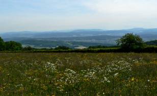 Looking over meadows towards distant Berner Oberland 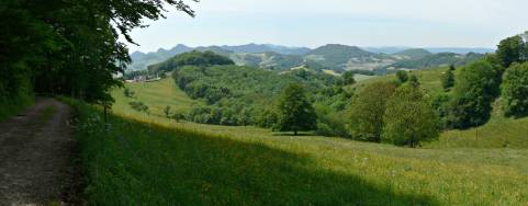 Lush greenery by Romatten 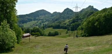 The Belchenflue ridge on the way from Challhöchi 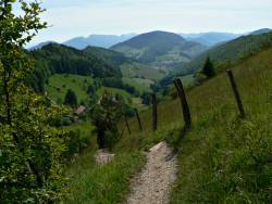 Descending towards Wuesthöchi |
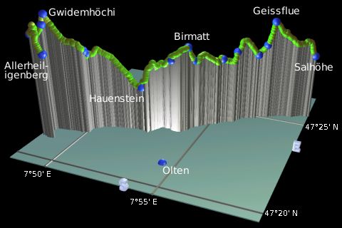 |
Salhöhe - Geissflue - Romatten - Burgweid - Froburg - Hauenstein - Challhöchi - Belchen - Allerheiligenberg
This day offers some great open panoramas and quiet countryside, although access is still easy. It finishes at the Höhenklinik at Allerheiligenberg, which is a short way off the Höhenweg from Wuesthöchi. If the walk is too long as described here, you can stop at Hauenstein instead where there's a bus stop.
From the bus stop at Salhöhe, follow the signposts up the road for a few yards until a track leads uphill to the left, signposted for Geissflue. As the track climbs, a signposted path turns off to the left climbing more steeply with some rockiness. As a special attraction you pass the highest point in the whole of canton Argau (gasp!) at a whopping 908m, before crossing into the next canton and climbing further. Eventually you reach the prominent lookout at Geissflue with great northward views.
Having toiled to the top, the path now leads on down the other side, dropping in steep zigzags to Schafmatt to meet the road. This road loops round to Romatten where a track leaves to climb across a meadow, shortly offering views on both sides of the slight ridge. The track leads through Bergmatten to Burggraben, where the path across the fields offers very open views to the south, including an unsightly cooling tower and if you're lucky a range of mountains in the distance.
Head towards the farm at Burgweid, taking the path around the side of the farm and up the slope to another great open panorama section through Birmatt and round and down to Froburg. At Froburg there's a panorama board showing all the names of the mountains, from Uri Rotstock past Pilatus and Titlis, past the Schreckhorn and the Jungfrau trio all the way to Mont Blanc and Gantrisch. If the air's clear, that is. They're quite a long way away.
From Froburg it's a more or less steady descent towards Hauenstein, where you emerge in the small village and cross the main road. Buses leave regularly from here to Olten should you wish to break your journey here.
The signposting onwards from Hauenstein is unusually weak - the yellow signs lead down a side road, which promptly forks in two, without a clear marking. Bear left here, following the road rather than the upward track, until another track leaves the road to the left. This begins a long, steady ascent above the plain, passing some impressive sets of concrete tank traps on the hillsides around Challhöchi. The military presence is clear in this area.
Curve round past General Willie Haus and follow the track uphill with open views to the left. As the track levels out you can see the Belchenflue ridge ahead with its tower on the right-hand side and the bare pass to the left of that which is Gwidemhöchi. The track leads ahead, climbing again, and reaching over 1000m for the first time (!) by Belchen, before dropping down over Gwidemhöchi into some lush green rolling scenery on the other side. Follow this stepped path down and round to Wuesthöchi, where we branch off the Jura Höhenweg to the Allerheiligenberg bus stop.
Getting to the bus stop requires a 15 minute detour and a 90m descent through the trees on a stepped path. The bus stop is just in front of the Höhenklinik, with a rather irregular and infrequent bus service - check the times in advance to make sure you don't get caught out. The last (mini)bus currently leaves around 6pm.
The following are the coordinates for waypoints along this route, obtained from GPS. They can be used either in another GPS, or along with a map, to provide additional references if necessary.
                          Latitude       Longitude      Altitude(m)
     Salhöhe             N 47°25'42.3    E007°59'14.1     779
     Geissflue           N 47°25'11.2    E007°57'25.0     962
     Romatten            N 47°24'54.6    E007°56'49.5     793
     Burggraben          N 47°24'09.6    E007°55'27.7     791
     Burgweid            N 47°23'32.5    E007°54'23.6     802
     Froburg             N 47°23'01.6    E007°53'38.0     820
     Hauenstein          N 47°22'40.2    E007°52'21.5     674
     Challhöchi          N 47°22'09.1    E007°50'03.9     847
     Belchen             N 47°21'41.9    E007°48'30.4    1045
     Gwidemhöchi         N 47°21'36.7    E007°48'27.5     998
     Wuesthöchi          N 47°21'15.3    E007°48'12.7     966
     Allerheiligenberg   N 47°21'09.0    E007°48'51.2     880
To view this hike in Google Earth or Google Maps, see the Kmz file for the whole Jura Ridgeway on the main page.
The next section on this hike is Allerheiligenberg to Balsthal.