
Hike time: | 5.5 hours |
Approx dist: | 17 km |
Start: | Col de Marchairuz |
Finish: | St Cergue |
Profile: | Between 1040m and 1490m, |
Rating: | Mostly easy, some slippy bits |
Greetings: | Bonjour |
This page describes the sixteenth day of the Jura ridgeway walk, from Col de Marchairuz along the ridge to St Cergue. The scenery is a mix of grassy woodland and open ridgetop, with views of Mont Blanc and La Dôle.
Col de Marchairuz has a bus stop but the service is very infrequent and is currently not running at all. St Cergue has a train line with connections to Nyon.
For St Cergue, there are a few hotels listed at st-cergue.ch including the Hôtel de la Poste (closed Monday nights and Tuesdays, single costs "from CHF 90").
One alternative a bit further out is the Chalet le Coutzet, a "Naturfreundehaus" or "Amis de la nature". It's basically like a youth hostel, you can cook for yourself and clean up after yourself. Beds are standard dorm mattresses with blankets, bring a sheet sleeping bag. And food. Welcome is friendly but lively school trips can dominate the atmosphere. Costs CHF 25 without breakfast. To walk there (N 46°26'52.8, E006°08'02.7, 1144m) it's another 2.8km from St Cergue station, just follow the Jura signs out of St Cergue to La St-Cergue (see day 17) and then follow the road to the right until you see the sign for "le Coutzet" up to the left.
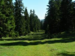 Grassy path between the forests 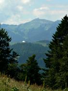 View ahead to La Dôle 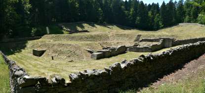 Ruins of Oujon monastery 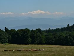 Mont Blanc towering above Lac Léman 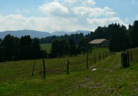 The path ahead towards La Dôle |
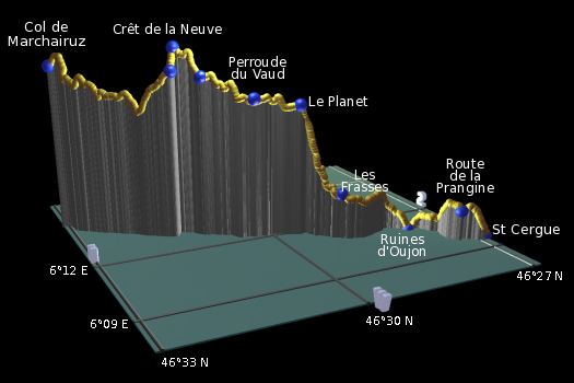 |
Col du Marchairuz - La Neuve - Crêt de la Neuve - Perroude de Marchissy - Perroude du Vaud - Le Planet - Les Frasses - Ruines d'Oujon - Route de la Prangine - St Cergue Gare
From the hotel at the Col de Marchairuz, the overgrown path leads up between the trees, weaving its muddy and slippy way over the hill with some short steep descents. Shortly it emerges into a wide grassy corridor between the woods, heading steadily downhill. This then climbs steeply towards La Neuve, offering views behind to Mont Tendre and the Dent du Vailon. It always looks impressive to see the route of a hike on this scale.
At La Neuve the path breaks sharply left, climbing further to Crêt de la Neuve and the sudden return of the southward panoramas, dominated by the massive Mont Blanc and Lac Léman. There's a lookout point here and panorama boards marking the distant peaks.
The descent on the other side is grassy and gentle, passing through Perroude de Marchissy and continuing on an easy track to Perroude du Vaud. Turn left here and follow the road (or the marked track just to the side of the road) until a path breaks off to the right. This climbs briefly before dropping to Le Planet. Looking ahead to La Dôle, you can now make out the golfball-like structure on the summit.
The path now crosses to the left side of the ridge, but only offers tantalising glimpses south inbetween the trees. As the path descends, there's just one perfect picnic spot before the path plunges further down into the trees. It gets a bit slippy in places before emerging into another grassy corridor between the mixed woods, which is again utterly quiet.
The path makes a small right-left jink, to Les Frasses, passing through a nature reserve. You may be lucky and see chamois, deer or other animals here. The track continues to descend before suddenly an incongruous set of ruins just sits there in the middle of the thick forest, surrounded by a low wall. It's the ruins of an old remote monastery, abandoned in the 1500s. There's not much, if anything, left of the original structures though, even the earthworks are reconstructed. Still, it's fascinating to think that this was a medieval charterhouse cut off almost completely from the outside world.
We briefly follow the signs and boards of a "chemin spirituel" before forking right and climb to regain the southward panoramas including Mont Blanc. The faint path traverses the grassy slopes with open panoramas, before cutting right up through the trees. The track then leads down to Route de la Prangine where we take the road to the left, cutting right at the bench and following the paths, tracks and lane down to the station at St Cergue.
From the station, the village centre is just a few hundred metres further on, following the Jura signs to the right past the cafe to the main roundabout. Or to stay at Chalet le Coutzet it's another 3km, see the description under 'accommodation' above.
The following are the coordinates for waypoints along this route, obtained from GPS. They can be used either in another GPS, or along with a map, to provide additional references if necessary.
                          Latitude       Longitude      Altitude(m)
     Col du Marchairuz   N 46°33'10.0    E006°15'01.9    1446
     La Neuve            N 46°31'32.7    E006°13'03.9    1444
     PerroudedeMarchissy N 46°31'05.4    E006°12'51.7    1429
     Perroude du Vaud    N 46°30'22.3    E006°12'10.0    1381
     Le Planet           N 46°29'38.6    E006°11'50.9    1363
     Les Frasses         N 46°29'06.1    E006°11'10.7    1151
     Ruines d'Oujon      N 46°27'50.4    E006°10'57.3    1040
     RoutedelaPrangine   N 46°27'23.2    E006°09'43.8    1115
     St Cergue Gare      N 46°26'55.2    E006°09'35.9    1046
To view this hike in Google Earth or Google Maps, see the Kmz file for the whole Jura Ridgeway on the main page.
The next and final section of this hike continues over La Dôle to Borex where it ends.