
Hike time: | 4 hours |
Approx dist: | 13 km |
Start: | Ballaigues |
Finish: | Le Pont |
Profile: | Between 760m and 1070m, |
Rating: | Mostly very easy |
Greetings: | Bonjour |
This page describes the fourteenth day of the Jura ridgeway walk, from Ballaigues past the Grottes de l'Orbe to Le Pont by Lac de Joux. There are two highlights to this short day's walk - firstly the caves at Grottes de l'Orbe, and at the end, the beautiful lakeside scenery at Lac de Joux and Lac Brenet.
Ballaigues has bus connections to Vallorbe, a train station along the route. Stopping at Vallorbe would be an option but this would make the following stage to Le Pont rather short. At the end of the walk at Le Pont, there are hourly trains back to Vallorbe.
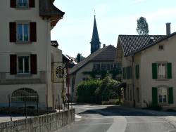 The small village of Ballaigues 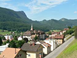 Vallorbe and the Dent de Vaulion 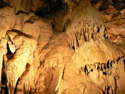 Inside the Grottes de l'Orbe 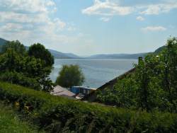 Lac de Joux 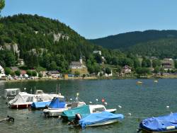 Lakeside at Le Pont |
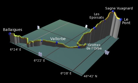 |
Ballaigues - Vallorbe - Grottes de l'Orbe - Saigne Geret Dessus - Les Epoisats - Sagne Vuagnard - Le Pont
From the signposts in the centre of Ballaigues, follow the road through the small village towards the west, with views out over the valley to the left and the nose-shaped outcrop ahead. This outcrop is the Dent de Vaulion, and our route passes to the right of this on its way up to the Lac de Joux.
Follow the lane dropping down from the road, curving round to cross the highway over a short bridge. A track then leads ahead to the right, becoming a road before a track leads leftwards down to cross a small dam and a main road. On the other side the lane climbs between houses to follow the railway tracks towards the Dent de Vaulion.
At Pont Suisse, the path crosses the railway above Vallorbe and then follows to the left of them to reach the station at Vallorbe. The impressive spired building below is the Collège de Vallorbe.
From the station, follow the signs ahead along the road, branching left downhill towards the Grottes de l'Orbe. On the peak to the right of the Vaulion, you can see hydroelectric pipes implanted up the side.
The Grotte signs lead down the quiet road to the Cafe de la Source, where the road splits with two ways to the caves. The left-hand route is more direct if you don't want to visit the caves, but the right-hand route is more scenic through the woods along a quiet riverside path. This loops round to the Grottes de l'Orbe and the entrance to the caves.
If you want to enter the caves it'll cost you CHF 15 per adult, which is quite expensive but inside it's very well done - good lighting, well-prepared tunnels and access stairs, and a very informative numbered guide. It makes quite a long and varied circular tour, with a hall of crystals and fossils at the end.
Continuing from the cave entrance the path doubles back to Vallorbe la dernier, passing underneath the hydroelectric pipes seen earlier. Then it branches rightwards and starts to climb fairly steeply up a narrow path through the trees. A flattening out brings a little respite before the climb resumes up to Saigne Geret Dessus.
Some parts of the path pass through waist-high grasses before climbing up to Les Epoisats, emerging from the trees into a wooded bowl. It almost seems like a dead-end until the road swings suddenly round to the right between the rocks, passing several more tank obstacles and barriers as it descends towards Le Pont.
The signpost at Sagne Vuagnard marks the continuation of the ridgeway route towards Mont Tendre - we'll carry straight on to Le Pont but we'll backtrack here on the next stage to continue our journey.
The Lac de Joux appears suddenly and unexpectedly, providing postcard-perfect lake scenery with rounded, wooded shores and bright yellow pedaloes. Oddly there's no signpost at the lakeside itself but following the shore to the right brings you shortly to the train station at Le Pont. The trains (or currently replacement buses) leave once an hour, so the shores of Lac de Joux or the Lac Brenet just over the bridge offer some good picnic spots and paddling opportunities while you're waiting.
The following are the coordinates for waypoints along this route, obtained from GPS. They can be used either in another GPS, or along with a map, to provide additional references if necessary.
                          Latitude       Longitude      Altitude(m)
     Ballaigues          N 46°43'47.1    E006°24'57.0     862
     Pont Suisse         N 46°43'02.9    E006°23'11.1     812
     Vallorbe Gare       N 46°42'43.8    E006°22'15.0     806
     Cafe de la source   N 46°42'11.1    E006°20'58.5     774
     Grottes de l'Orbe   N 46°41'55.4    E006°20'43.9     779
     Vallorbe la dernier N 46°42'06.6    E006°20'57.7     759
     Saigne Geret Dessus N 46°41'19.3    E006°20'36.8     942
     Les Epoisats        N 46°40'41.1    E006°20'23.2    1029
     Sagne Vuagnard      N 46°39'59.7    E006°20'12.0    1070
     Le Pont Gare        N 46°40'05.7    E006°19'28.6    1008
To view this hike in Google Earth or Google Maps, see the Kmz file for the whole Jura Ridgeway on the main page.
The next section on this hike continues over Mont Tendre to Col du Marchairuz to the southwest.