
This analysis aims to show the movement of the GPS satellites in the sky and the coverage of the sky including the so-called "north hole". It uses both experimental observations with Garmin receivers and also nominal calculated positions.
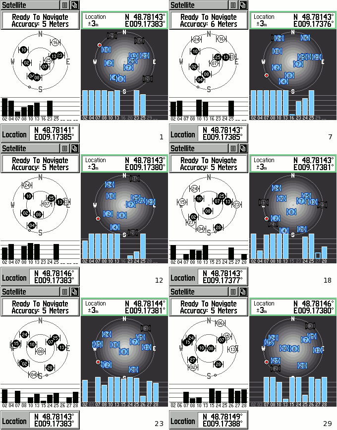
 Animation of the satellite views from both units, Vista on left, Vista HCx on right |
This animation of the satellites in view comes from the receiver sensitivity analysis, and shows the approximate positions of the satellites in the sky according to the two Garmin receivers. The zenith is in the centre of the circle, and the horizon with the four compass points forms the outside of the circle.
From this animation, it appears that the satellites are uniformly spread over the sky hemisphere. However it can be shown that if all the GPS satellites have inclination angles of 55°, none of them can approach closer than 35° to the north pole. Therefore, you should expect to see a "hole" in the satellite coverage, a circular area where the satellites don't go.
 Combined image of satellite coverage, Vista on left, Vista HCx on right |
This effect becomes more extreme the further away from the equator you go - so at the very north pole there will be no GPS satellites directly overhead, and this "north hole" will be circular. As you go further south towards the equator, the hole will get smaller and will shift to the north of the zenith, until at the equator the hole will vanish. In the southern hemisphere the same hole will occur in the south (called the "south hole"), getting bigger and higher until it's overhead at the south pole again.
In order to verify this, we can combine the images for the whole observation period, and see if the hole appears. Note however that the observation period used here is still fairly short, being only a couple of hours. The results are shown to the right.
Both units show very similar tracks, with only minor differences between them. Surprisingly there is indeed an area to the north which is not crossed by satellite tracks, although near the horizon some satellites do pass quite close to north. It is difficult to verify the presence of this hole with the limited data, and it almost appears that there is another hole in the southeast, even though there shouldn't be. The recording time here is limited by the laptop battery life, unfortunately.
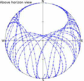
In addition to these measurements, it's possible to obtain the nominal positions using the broadcasted ephemeris parameters. One source of such data is Wolfram|Alpha which provides altitude and azimuth coordinates of all the satellites from the user's location. Unfortunately it doesn't seem possible to choose another location, but the following data was extracted with the same location as the measurements, at roughly 49° North.
 Plot of satellite tracks above horizon showing "north hole" |
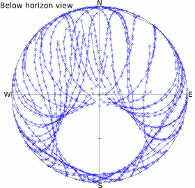
 Unreachable satellites below horizon showing "south hole" |
Two plots are shown here, one for the satellite positions above the horizon, and one for those below. Obviously for ground-based receivers, only the satellites above the horizon stand a chance of being received, and those close to the horizon will suffer from larger atmospheric distortion and blockage.
Clearly visible on both these plots are the "holes" in the sky where the satellites do not appear. Obviously the southern hole here is academic but the northern hole is real and can have an impact on signal reception if other parts of the sky are obstructed. The further north you go, the larger and more overhead this hole will be. Similarly, in the southern hemisphere the above-horizon hole will be to the south and will become more extreme for more southerly latitudes.