
Hike time: | 2.5 hours |
Approx dist: | 5 km |
Start: | Top cable car station of Fellhorn |
Finish: | Middle cable car station of Fellhorn |
Season: | Summer |
Profile: | from 1960m up to 2030m and down to 1770m |
Rating: | Medium difficulty on narrow path |
Greetings: | "Guten Tag", "Hallo" |
Map link: |
The Fellhorn is a dramatic mountain just south of Oberstdorf in Allgäu, on the border with Austria.
This ridgetop hike has just a short easy climb from the top cable car station up to the summit itself, and then a long ridgetop traverse to the north and northeast. Then the path descends past the small lake of Schlappoldsee and ends at the middle cable car station for the ride down.
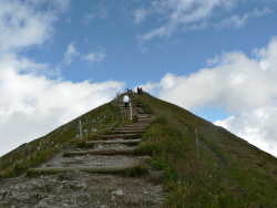 The summit of the Fellhorn 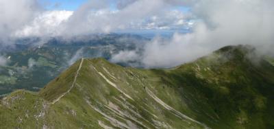 Long ridgetop from the summit 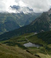 Schlappoldsee 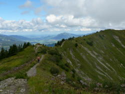 More open ridgetop |
You can reach the lower cable car station by foot from Oberstdorf, south of the village right on the border with Austria. Oberstdorf itself is easily reached by car or by train (see Anfahrt in German for driving directions).
The cable car currently costs 22.50 EUR per person for a day ticket, although several hotels and guest houses offer special deals for their guests for half price. The parking at the lower cable car station is not free, but the parking ticket (2.50 EUR) includes a voucher for a small discount in the mountain restaurants.
This kmz file (3 kb) contains waypoints from this Fellhorn hike and shows the path as a red line along the ridgetop. Simply open it in Google Earth (File -> Open) and you'll see the route in full. Press the "Play Tour" button below the listed waypoints and you can fly a tour along the hike in 3d.
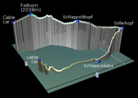
Fellhorn Bergstation - Fellhorn summit - Schlappoldkopf - Söllerkopf - Schlappoldalpe - Fellhorn Mittelstation
 |
After taking the cable car all the way to the top, there's just another 80 metres or so to climb to reach the Fellhorn summit. The path is clearly marked, straight up and easily stepped so it only takes around 15 minutes to reach the peak. In fact you're already on the international border even on the way up, so you have Austria on your left-hand side and Germany on your right-hand side.
And from the summit of the Fellhorn we continue along the country border, following the spectacular sharp ridgetop leading ahead. There are some short descents of medium difficulty on the narrow path, but the clear path soon flattens out so that you can enjoy the marvellous views in all directions.
The path climbs a little to the unmarked peak of Schlappoldkopf, and from here the small lake of the Schlappoldsee is visible far below to the right. The undulations of the ridge continue, with a gradual descent and a small gentle rise to the also unmarked Söllerkopf.
From this last peak we turn sharp right and leave the ridgetop, and leave the international border, and head downhill into Germany. Some of this descent is a little awkward, with some rocky steps and some rootiness, but it's a straightforward path down the side of the hill towards Schlappoldalpe. Here is a cheese dairy, well-known in the area, and it sells simple cheese and meat plates and bottled drinks on the small terrace. For the kids there are rabbits and goats to admire too!
Heading back towards the middle station of the cable car, there are two possible ways - an easy, flat track or a footpath forking off to the right. Both routes end up at the little lake of Schlappoldsee, but the track way has information boards about the cheese-making process at the dairy. From the Schlappoldsee it's just a short climb past (or between) the cows, winding back up to the cable car building with its restaurant. After refreshments you can then take the easy way down in the cable car back to the car park.
The following are the coordinates for waypoints along this route, obtained from GPS. They can be used either in another GPS, or along with a map, to provide additional references if necessary.
                           Latitude       Longitude    Altitude(m)
       Fellhorn Talstn    N 47°21'08.0    E010°15'46.9     913
       Fellhorn Bergst    N 47°20'52.9    E010°12'57.1    1965
       Fellhorn           N 47°21'02.2    E010°13'03.4    2035
       Schlappoldkopf     N 47°21'26.6    E010°13'21.6    1965
       Söllerkopf         N 47°21'48.3    E010°13'44.4    1923
       Schlappoldalpe     N 47°21'29.2    E010°13'49.5    1696
       Fellhorn Mitstn    N 47°20'57.2    E010°13'35.8    1772
The main website for the cable car is at fellhorn.de but is unfortunately only available in German. However it does have a good overview map.
You can also see the wikipedia's page on Oberstdorf, and for more general tourist information on the area, see Allgäu info.