
 |
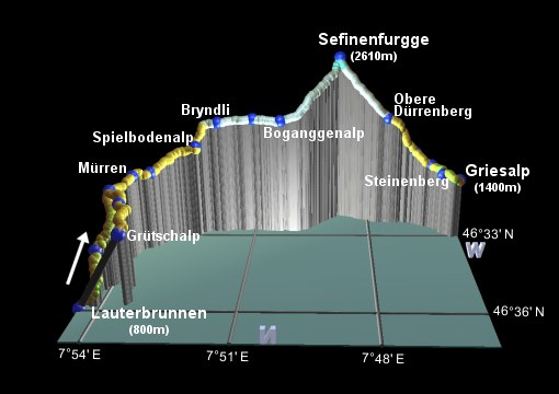
This is the eighth stage of the Alpine Pass Route, crossing from Lauterbrunnen past Mürren and over the Sefinenfurgge to Griesalp. Here it is described as a two-day hike, because the climb from Lauterbrunnen up to the pass would be too much to do in one day. An alternative starting point is the top of the cable train at Grütschalp, which cuts 600m off the climb but still leaves a fair bit of legwork for a single day.
Most of this route is on fairly easy paths or tracks, apart from either side of the summit. Here, especially on the descent, it can be quite steep and loose - more than one walker found themselves sliding around on the shale after the recent rain. The steps down from the pass look scary but just take a bit more time to negotiate.
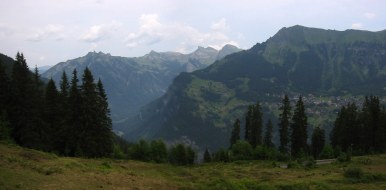
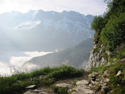
The descent towards Griesalp is spectacular with dramatic rock formations and wide-ranging views. Those heading straight on for the next stage of the walk over to Kandersteg don't actually have to go all the way into Griesalp itself, but can cut the corner off and head up to Bundalp instead.
A quick note about the name of this pass, it's written in various different ways on signposts, for example Sefinenfurka or Sefinen Furke - here I stick to Sefinenfurgge because that's what it says on the pass itself. Note that "gg" is pronounced as a "k" anyway, so it doesn't matter all that much.
Lauterbrunnen is a scenic 20-30 minutes' train ride away from Interlaken Ost, and a popular junction for travellers to Wengen and the Jungfraujoch. For those wishing to start from Grütschalp, the cable train crawls up the sheer mountainside from just across the road from the train station at Lauterbrunnen. From the end of the walk at Griesalp, there is a steep and scenic postbus ride down the valley to Reichenbach (watch out, last one leaves at 4:40pm!), with connecting trains from there towards Kandersteg and Spiez.
From Zürich, the quickest way to/from Interlaken is via Bern, sometimes requiring a change there, making the outward journey about 3 hours and CHF 34. Coming back, the post bus to Reichenbach is about 40 minutes and CHF 8, and then from there back through Spiez and Bern to Zürich takes another 2h30 and CHF 29 (all prices assuming half-price card).
For Wengen, Lauterbrunnen and Mürren, see wengen-muerren.ch or gimmelwald.ch for a variety of choices. Spielbodenalp is conveniently located to split up the climbing, and the Pension/Restaurant Spielbodenalp offers dorm beds and double rooms for CHF 35 / 50 including basic breakfast (but no showers). Unfortunately this place is only open from June-September and only at weekends. The Rotstockhütte is also well-positioned and the Pension Sonnenberg in Suppenalp comes recommended from fellow walkers.
For Griesalp and Bundalp, try griesalp.ch for a small list.
Lauterbrunnen - Wintereggalp - Mürren - Spielbodenalp - Boganggenalp - Sefinenfurgge - Obere Dürrenberg - Steinenberg - Griesalp
Hike time: | 4 hours |
Approx dist: | 9 km |
Start: | Lauterbrunnen station |
Finish: | Spielbodenalp |
Profile: | from 800m up to 1800m |
Rating: | easy |
As mentioned, there are (at least) two choices for the start of this hike, either from Lauterbrunnen or from Grütschalp. For those insisting on walking every step of the Alpine Pass Route without taking trains or cable cars, you'll be starting from Lauterbrunnen station where the previous stage over the Kleine Scheidegg finished up; for those more open to persuasion the cable train can whisk you up from Lauterbrunnen to Grütschalp giving you an easy traverse across to Mürren instead of a 600m climb.
From Lauterbrunnen station, the signposts to Mürren lead leftwards up the road towards the waterfall, before
branching rightwards up between the houses. At the time of research there was a small landslip blocking part of the path
in a small section, but apart from that the path is easy, climbing steadily up through the trees.
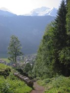
Path up from Lauterbrunnen
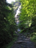
Path up past waterfall
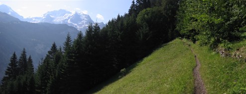
Traversing towards Mürren
Passing the occasional waterfall, and traversing the occasional open grassy slope, you reach a picnic area after around an hour, which provides a welcome breakpoint from the ascent.
Back on track, and climbing steadily once again, the signs continue to point to Mürren and the views leftwards
over the valley provide the encouragement. Another 1h10 or so brings you up to meet the train tracks at Wintereggalp,
from where it's an easy 25 minute stroll along the track to the station at Mürren.
Broad track from Grütschalp
View across valley to Schynigge Platte, Wengen and Männlichen
If you're starting from Grütschalp instead of Lauterbrunnen, you'll find yourself already at almost 1500m, so the walk to Mürren is only very gently uphill. A train track connects the two, and the broad, level path follows the tracks more or less, a bit higher up the slope.
From this track you get clear views across to Wengen, sitting a little lower on the opposite side of the valley, with the Männlichen ridge above and the massive snow-capped mountains above. On this popular (and pushchair-friendly) section, you reach Winteregg (with restaurant and dairy) after around half an hour, and Mürren after another half hour or so.
Of course, if you're taking the train up to Grütschalp you could even take the train from there to Mürren as
well, skipping this bit of the walk and making it easier to squash the rest of this stage into a single day.
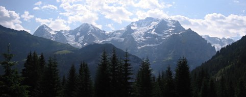
Can you name this famous trio?
Through the village of Mürren
Mürren is a picturesque and lively village, with ski-resort trappings - cable car stations, cable trains and souvenir shops. And also great views across to the famous trio of Eiger, Mönch and Jungfrau. The main road (signposted for the Sefinenfurgge already) leads through the town to the cable car station, with connections upwards to the Schilthorn (via the prominent intermediate station of Birg) and downwards to Gimmelwald.
Follow the signs uphill past the cable car station, away from the souvenir shops and into the wilderness.
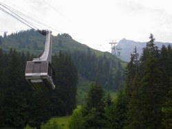
Cable car heading up to Birg
Mürren, Kleine Scheidegg, Eiger and Jungfrau
North Face Trail up towards Spielbodenalp
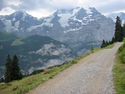
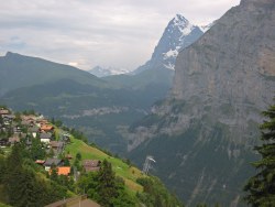
Quickly leaving the village behind, the road climbs up and allows views back to the Kleine Scheidegg crossed on the last stage of this route. You can even see beyond to the Wetterhorn, marking where the Grosse Scheidegg sits even further away. But it's the Jungfrau which soon dominates the view, looming overhead and drawing the eye along the ridge to the Breithorn and Tschingelhorn.
Soon the signposts offer a choice - either stay on the road (which is soon a broad and quiet track) to
Spielbodenalp, or take the confusingly-named "North Face Trail" (which is a narrow and occasionally rooty
footpath) also going to Spielbodenalp. Take your pick, but the footpath is more interesting and offers
better views as it rounds the corner towards the Gspaltenhorn.
Schilthorn ahead, Sefinenfurgge to left
Enjoying the sunshine at Spielbodenalp
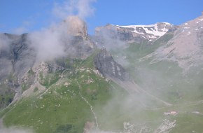
Around the corner, you now get to see the summit of the Schilthorn, which was previously hidden behind Birg. The cable car between them is suspended spectacularly above the void. Continue to follow the Spielbodenalp signs, crossing the stream to reach the restaurant/pension Spielbodenalp after around 50 minutes from the Mürren cable car.
Looking up at the Schilthorn, it's difficult to believe that people race up to the summit, and not only that
but they start from Lauterbrunnen! If a 21km race with over 2100m of climb doesn't sound like a completely crazy
idea to you, then check out inferno.ch for the
full details.
Hike time: | 6 hours |
Approx dist: | 13 km |
Start: | Spielbodenalp |
Finish: | Griesalp |
Profile: | from 1800m up to 2610m and down to 1400m |
Rating: | medium-tricky |
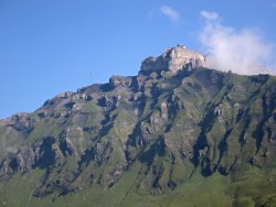
Around the ragged rocks of Birg
The cowbells and clucking chickens of Spielbodenalp provide a tranquil setting in which to admire the views,
with the imposing Birg looming above the cliffs and the snowy peaks across the valley. The signposts lead the way past
the restaurant and up a serene grassy footpath.
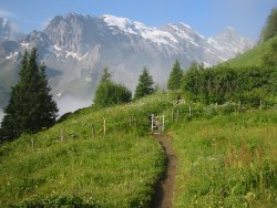
Path from Spielbodenalp
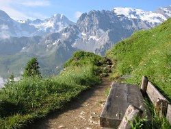
Bench with a view
View from the steep path
Shortly the path starts to climb in earnest, in switchbacks and in places quite steeply. Fortunately there are plenty of benches thoughtfully placed here on which to catch your breath! The views are spectacular.
The climb continues up to around 2000m, where the path turns the corner and suddenly levels out by Bryndli.
First view of pass, somewhere in the middle of the picture
Rotstockhütte in lower-right, and the pass top-centre
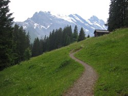
The path makes an idyllic, flower-filled traverse on its way through Oberläger to Boganggenalp, and offers the first tantalising glimpses of where the upcoming pass is going to be. Heading straight towards the sheer rocky ridge, a notch gradually opens up, with the Rotstockhütte marking the start of the ascent.
This hut, reached in around 1h30 from Spielbodenalp, offers another alternative overnighting place or refreshment
stop.
Beginning the climb towards the pass
Final steep ascent
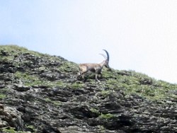
An Ibex on the steep rockface
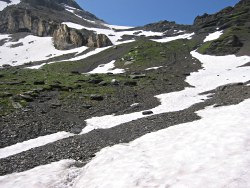
Leaving Boganggenalp, the way is clear, straight up to the skyline. There's some snow up there but not too much. It does look steep though.
After climbing up through the lower grassy slopes of the chute, you eventually reach the snow and shale, and then it starts getting steep. The snow definitely doesn't make things any easier, this pass isn't one to attempt early in the season. But the summit does gradually get closer as the path snakes left and right, and after around 1h30 from Boganggenalp you finally get to the crest and peer over the other side.
The pass is very small, and steep on both sides, making it a very sociable huddle of like-minded hikers gathering at the top
for recuperation and a satisfying rest. This marks the highest point of the Alpine Pass Route so far, and the second-highest
pass of them all - topped only by the next one on the list, the Hohtürli.
View back down from the pass
Long staircase down the other side
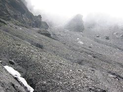
Bleak and misty slope
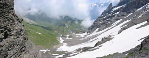
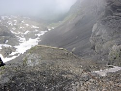
Although the view back down towards Mürren may be satisfying, the view onwards towards Griesalp is anything but! It's very steep. And it's covered in a loose, slippy shale. Fortunately someone's thought of this, and helpfully provided a (very) long set of wooden steps leading down off the summit.
Still, it's awkward even with this help and some walkers were unpleasantly surprised - surprised enough to take an
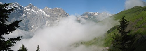
involuntary sit-down! This side of the pass has a very dramatic, raw, bleak atmosphere, especially with the mist that
was lingering - quite a different character from other passes so far.
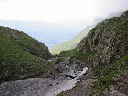
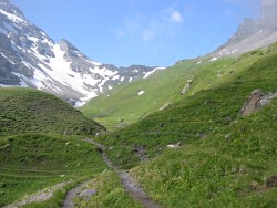
Path through small river gorge
Path down the valley towards Griesalp
The grey shale is soon left behind, and the path descends through rough sheep pasture. A small but energetic river cuts a small
gorge on its way down, and the valley beyond gradually appears through the mist and haze. The walls of this valley are impressively
rugged and layered, and the path drops steadily and fairly steeply down to Obere Dürrenberg (where drinks are available) after
around an hour.
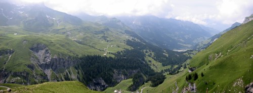
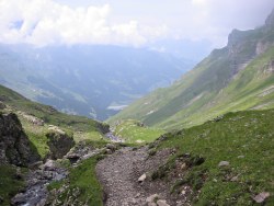
Panorama down the valley
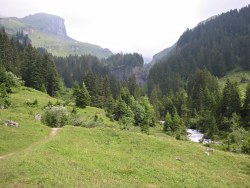
Lush riverside scenery
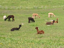
Llamas near Griesalp
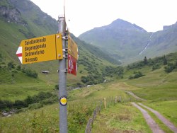
From here the path drops down to the left round some rocky switchbacks, some of which are a bit awkward. Shortly this path meets a vehicle track which leads a bit more straightforwardly to Bürgli in around half an hour.
A signpost at Bürgli points leftwards to Bundalp, but it's perhaps better to continue rightwards towards Griesalp as far as the river before branching off, if you're going that way. Initially following the road (yes a road!), a footpath sign offers a quieter alternative through the trees, reaching a bridge across the seething grey torrent of a river after around 15 minutes. Here is where the signposted path to the Hohtürli branches off leftwards, across the river and back uphill on the other side.
We'll continue to follow the river downhill towards Griesalp, however, dropping gently down to Steinenberg in around 15 minutes and Griesalp in another 15. The numerous 'bus' signposts lead you up to an open square in which the crowds relax waiting for the (very infrequent) buses down-valley to Reichenbach.
The next stage of the Alpine Pass Route continues from Griesalp over the Hohtürli down to Kandersteg.
The following are the coordinates for waypoints along this route, obtained from GPS. They can be used either in another GPS, or along with a map, to provide additional references if necessary.
                           Latitude       Longitude    Altitude(m)
       Lauterbrunnen Stn  N 46°35'53.7    E007°54'28.5     800
       Picnic area        N 46°35'19.7    E007°54'13.0    1212
        (Grütschalp)      N 46°35'46.8    E007°53'28.2    1485
        (Winteregg)       N 46°34'55.4    E007°53'44.8    1578
       Wintereggalp       N 46°34'29.5    E007°54'06.8    1620
       Mürren             N 46°33'48.9    E007°53'48.9    1638
       Spielbodenalp      N 46°32'55.9    E007°52'27.4    1793
       Bryndli            N 46°32'45.1    E007°51'54.2    2025
       Oberläger          N 46°32'39.9    E007°51'00.5    2051
       Boganggenalp       N 46°32'44.9    E007°50'18.0    2039
       Sefinenfurgge      N 46°31'53.7    E007°48'46.5    2612
       ObereDürrenberg    N 46°32'16.4    E007°47'30.3    1995
       Bürgli             N 46°32'17.0    E007°46'45.9    1617
       Steinenberg        N 46°32'49.7    E007°46'07.6    1470
       Griesalp           N 46°32'51.1    E007°45'41.9    1408
For local information, see wengen-muerren.ch. A good overview drawing of the Grindelwald area is at jungfraubahn.ch under English-> Jungfrau Region-> Maps. At schilthorn.ch there's a panoramic hiking map (pdf) which is also available in paper from the cable car stations in Mürren. There's some information about the Griesalp area (now in German only) at kiental.ch.