
 |
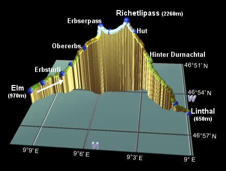
This is the second stage of the Alpine Pass Route crossing the Richetlipass from Elm to Linthal. It's quite a long day, with a hefty climb and an even heftier descent. The going is easy-medium, apart from some steep and tricky bits on the descent, but it does make for a tiring excursion. There didn't seem to be any overnighting possibilities on the way, but it can be cut a bit shorter by taking the bus from Elm to Obererbs.
Both Elm and Linthal are connected to Schwanden by regular trains or buses. From Schwanden it's then a 25 minute train ride up to Ziegelbrücke, which is the main gateway station.
From Zürich, there are hourly connections to Elm via Ziegelbrücke and Schwanden. This train-train-bus combo takes around 1h50 and costs CHF 15 one-way with halbtax. The return trip is usually a train to Ziegelbrücke and then the train from there to Zürich, but later in the evening the first stretch of the train trip is replaced by a bus as far as Schwanden. Either way it takes around 1h40 and costs CHF 13 one-way with halbtax.
There wasn't anywhere obvious to overnight on the way, so your best bet is at Elm and/or Linthal. For Elm, see elm.ch, and for Linthal see linthal-rueti.ch for lists of hotels etc. Also glarusnet.ch has lists for Braunwald, should you wish to continue up there for the night.
In Linthal, the easiest place to find is the Hotel Bahnhof, right by the station (from CHF 40 for a room), with the Hotel Adler (from CHF 35 for a dorm) near the blue-faced clock, and the Hotel Raben (from CHF 45 for a room) near the red-faced clock. I'm also told there's a Bed & Breakfast run by the Family Manser-Betschart (Tel: 055 643 2261) close to the post office on the Sändlistrasse, offering B&B for CHF 40.
Elm - Büel - Obererbs - Erbserpass - Wichlenmatt - Richetlipass - Hinter Durnachtal - Linthal
Hike time: | 8.5 hours |
Approx dist: | 23 km |
Start: | Elm bus station |
Finish: | Linthal train station |
Profile: | from 960m up to 2220m, and all the way down to 650m |
Rating: | easy-medium with some awkward bits on the descent |
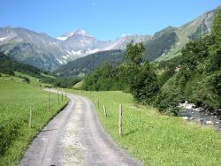
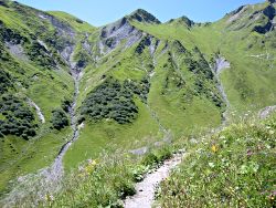
The route starts from the bus stop at Elm, with the signposts already pointing you towards the Richetlipass. Instead of following the road, however, cut across left to the far more pleasant track alongside the river. Ahead of you you'll see the fork in the valley, with the Panixerpass heading left (South) and the right-hand branch leading up to the Richetlipass. Behind you, high up above Elm, you'll see the grassy saddle of the Foopass, conquered on the previous day of this route. This gives a great impression of the scale of the route, because it looks a long way away!
Riverside track away from Elm
Looking back to the previous day's Foopass
Shortly a signposted path leaves the track to the right, winding beside a brook before climbing up to join another track. This leads to a road at Stäfeli, and climbs up to meet the main road from Elm again at Erbstürli after around 1 hour.
From Erbstürli, continue on the road away from Elm, signposted Erbsalp and the Richetlipass. After around 25 minutes, you reach the turnoff at Büel, where the signposts lead up a smaller road to the right. This hairpins its way up the hillside, and the path takes a shortcut up to the right, amidst hosts of wild strawberries and raspberries. When the path rejoins this road, follow the road up to Obererbs, where you'll find a drinking fountain and the Skihütte Erbs. This is where the bus comes up to, should you wish to skip this first climb. It should probably take about an hour to reach here from Büel, but the berries along the way slowed us down quite a bit!
Continuing to follow the signposts towards Richetlipass and Linthal, the path climbs up the grassy cow-munched
slopes, all the time with a spectacular panorama down to the Elm valley. The route ahead is not obvious, but it
sidles around the grassy bowl to the left, heading for an indistinct grassy saddle on the horizon.
View back down to Elm
Looking up at the grassy saddle of Erbserpass
After around 1h30 (or more if you stop to admire the views!), you reach the saddle of Erbserpass, and if you
were expecting this to be the pass of today, then you'll realise your mistake here. Beyond this ridge is a
lush, sheltered bowl valley, and the real pass, the Richetlipass, is higher up beyond. This is a good spot for
lunch, with the last views back down to the Elm valley.
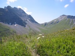
First view of the Richetlipass from the saddle
Take the footpath down the far side of the saddle, winding down towards the isolated farm of Wichlenmatt, about 120m lower than the saddle and about 220m below the pass itself. This idyllic bowl is filled with flowery marshland, with an easy path traversing the plain between the cows.
Continue beside the stream, until the path steepens and begins to climb the rocky slopes towards the pass.
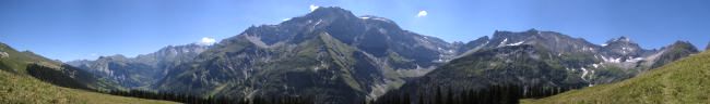
Eventually you zigzag your way up to the top, around 50 minutes from the saddle. As expected, the views
over the other side are spectacular, looking down the steep valley and across a swathe of peaks rippling
into the distance.
Views down the other side of the Richetlipass
Looking back up to the Richetlipass
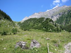
Follow the path steeply down the far side, taking care on the slippy and crumbly surface. Continue down to reach the small hut, about 20 minutes down from the pass. Presumably this hut is used by the owner of the sheep roaming around this valley, who in late July looked to be enjoying the heat wave not at all.
The path heads to the right, before curving back round onto the crest of a crumbly ridgetop. Follow this ridge down the valley, until the path dives down to the left. Here is the only awkward bit of the hike, where fixed cables have been placed on the steep, rocky switchbacks. Watch out for loose stones here, both underfoot and overhead.
From here the trail continues down the valley, crossing the river on a bridge and following a track down to a signpost at Hinter Durnachtal, reached after around an hour from the hut.
The track continues down beside the extraordinarily boulder-packed river, crossing again at the next bridge and
descending to meet a road. The signposts offer two routes to Linthal, giving you the choice of a track or a
stream-side "Bachweg". This Bachweg descends sharply on a narrow path, before following the stream, going through
a short tunnel and emerging on the road by a "Kärpf" signpost after around 1h20.
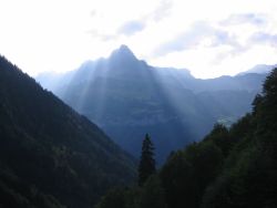
Mysterious rays of sunshine behind the Ortstock
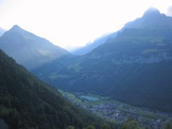
Anticipating the next day's ascent back out of Linthal
Straight ahead as you descend is the dolloped form of the Ortstock, towering above Linthal. The valley going up to the left of this leads up to tomorrow's destination, towards the Klausenpass.
Follow the road downhill to meet one of the main roads through Linthal, not far from the blue-faced clock tower, about 25 minutes from Kärpf. There's also a very welcome drinking fountain on the corner here. The main centre of the town is off to your left, towards the snow-capped Tödi and the adjoining glaciers, and the train station is a few minutes' walk straight ahead, with yellow signposts guiding the way.
Our next stage will take us over the Klausenpass, the third pass on this long route.
The following are the coordinates for waypoints along this route, obtained from GPS. They can be used either in another GPS, or along with a map, to provide additional references if necessary.
                           Latitude       Longitude    Altitude(m)
       Elm bus stop       N 46°55'20.2    E009°10'23.4     962
       Elm Sportbahnen    N 46°54'47.9    E009°09'43.4    1020
       Stäfeli            N 46°54'14.7    E009°08'34.1    1080
       Erbstürli          N 46°54'21.3    E009°08'27.5    1145
       Büel               N 46°53'56.4    E009°07'56.1    1261
       Erbsostafel        N 46°53'58.5    E009°06'50.3    1677
       Obererbs           N 46°53'59.4    E009°06'43.2    1710
       Erbserpass         N 46°54'01.8    E009°05'40.8    2156
       Wichlenmatt        N 46°53'58.1    E009°05'07.1    2037
       Richetlipass       N 46°53'53.0    E009°04'02.8    2261
       Hut                N 46°53'48.3    E009°03'33.8    2008
       Hinter Durnachtal  N 46°53'52.3    E009°02'26.3    1386
       Signpost Kärpf     N 46°55'19.1    E009°00'43.9     805
       Linthal            N 46°55'32.1    E008°59'52.7     648
Both elm.ch for Elm and linthal-rueti.ch have German summaries of this Richetlipass hike.
Day hikes in Braunwald are not very far away. And of course there's snowboarding in both Braunwald and Elm.