
 |
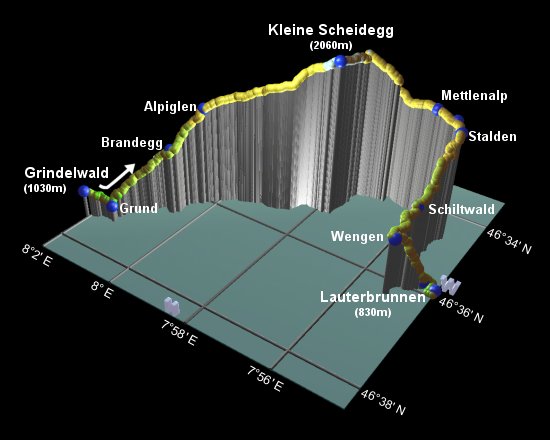
This is the seventh stage of the Alpine Pass Route, crossing from Grindelwald over the Kleine Scheidegg to Lauterbrunnen in the next valley. It forms the second part of a "Tale of Two Scheideggs", along with the previous stage of this route over the Grosse Scheidegg. Oddly, this "small watershed" is higher than the "big watershed" across the way, and is certainly vastly more popular, with the hordes of train trippers snacking and shopping there on their way to/from the Jungfraujoch.
After climbing up to the pass under the North Wall of the Eiger, this route takes a rather circuitous route round to Wengen, rather than just following the railway, which is just one of the many options for altering the route. The walk can easily be shortened by taking the train, in particular the route down from Wengen to Lauterbrunnen.
Both Grindelwald and Lauterbrunnen are connected by private railway to Interlaken Ost, both around 20-30 minutes train ride away. Therefore this hike is easy to do as a day trip, staying at any of several towns in the area. There are also train lines running from both Grindelwald and Lauterbrunnen up to Kleine Scheidegg itself, so there are many opportunities for taking short cuts.
From Zürich, the quickest way to/from Interlaken is via Bern, sometimes requiring a change there, with each journey taking around 3 hours and about CHF35. So you wouldn't want to do this as a day trip from Zürich, but instead maybe combine it with the previous or next stages of the route.
For Grindelwald, see grindelwald.com for a wide variety of accommodation. Grindelwald youth hostel (youthhostel.ch) sits high above town on Terrassenweg, and offers 6-bed dorms with warm bedding for CHF38 (non-member price). It's a friendly enough place with great Eiger views but lacks a comfortable lounge area.
For Wengen, Lauterbrunnen and Mürren, see wengen-muerren.ch for a variety of choices.
Grindelwald - Alpiglen - Kleine Scheidegg - Wengen - Lauterbrunnen
Hike time: | 7.5 to 8 hours |
Approx dist: | 23 km |
Start: | Grindelwald station |
Finish: | Lauterbrunnen station |
Profile: | from 950m up to 2060m, then down to 830m |
Rating: | easy |
From Grindelwald station, signposts lead you immediately towards Alpiglen and Kleine Scheidegg, which is clearly visible just under the massive Eiger. The paths initially descend though, as they head down towards the train station at Grindelwald Grund, a good 90m lower than Grindelwald and 170m lower than the Terrassenweg. Grund is reached in around 15 minutes from the main Grindelwald station.
Follow the signpost for Alpiglen, leading up the railway and crossing to the left-hand side. A mix of roads and steep paths
lead up to reach Brandegg (with restaurant and station) after around an hour. From the shadow of the Eiger, the views back
include the Grosse Scheidegg (from the previous day's stage), Grindelwald and the Faulhorn. There's also the merest glimpse
of the Silberhorn bathed in morning sunlight.
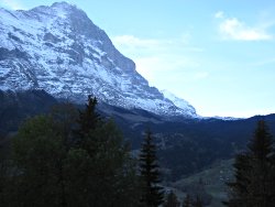
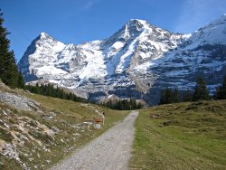
Looking up at the Eiger
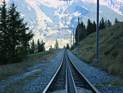
The easy way up and down
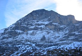
North Wall of the Eiger
Just below Alpiglen, the track passes through a tunnel underneath the railway, and a poorly-marked path heads up between the buildings to the signpost at Alpiglen itself (another half-hour from Brandegg). Here you'll find a hotel, a restaurant, and a railway station just a short distance uphill.
From here, the railway climbs steeply up in a covered tunnel, while the path departs to the right.
Gradually the Jungfrau appears, followed by the Mönch, as the October sun finally rises above
the massive Eiger.
Ahead to the restaurants at Kleine Scheidegg
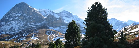
The Eiger on the left, the Mönch in the middle, and the Jungfrau to the right of the tree
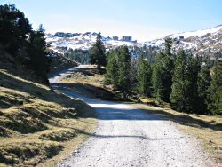
The track heads up towards the now-visible buildings on the summit of Kleine Scheidegg, and you realise that this isn't going to be one of those wild, remote, unspoiled passes far from civilisation. Well, you knew that already, if there's a railway station at the top.
The tracks and paths climb steadily up to the 2060m pass, reached in around 1h30 from Alpiglen.
At the top you'll find spectacular views back to the Grindelwald side, with the Eiger looming overhead,
the Eigergletscher sweeping down between the Eiger and Mönch, and the observatory/sightseeing station
up on the Jungfraujoch. You'll also find several restaurants, bars and souvenir shops, and hundreds of
people changing trains and admiring the views.
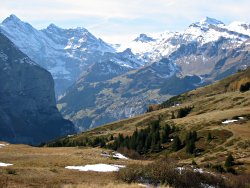
View across to the Sefinenfurgge and Schilthorn
Looking back up the track towards the Mönch
From the map at Kleine Scheidegg, you can see several possible routes down to Wengen. The shortest, easiest and quickest way is to follow the easy track alongside the railway, through Wengernalp and down to Wengen. Another alternative is to detour from Wengernalp on a longer track round through Bettlenalp, rejoining the railway at Allmend. A third option, even longer, curves round further to the West, passing Biglenalp and Mettlenalp before entering Wengen on a quiet road. This is the path we'll take this time, just to make the most of the views and keep away from the trains.
This long path starts off with a gentle descent to the left, forking away from the train tracks and soon revealing views forward to the Lauterbrunnen valley and the high-looking Sefinenfurka (the next pass on the Alpine Pass Route) to the left of the Schilthorn. Shortly the path reaches a ridge at Haaregg, and descends to Weisse Fluh after around 45 minutes.
Here, head leftwards away from Wengernalp and drop down a rooty path directly towards the Jungfrau.
When the path meets the stream, don't cross the bridge towards the two buildings, but continue down the
right-hand side of the stream and across a rocky stretch. There are constant, awesome views (and occasional
sounds) of the famous trio of Eiger, Mönch and Jungfrau from here. You should reach Mettlenalp in another
45 minutes or so.

Bird's eye view of the Lauterbrunnen valley
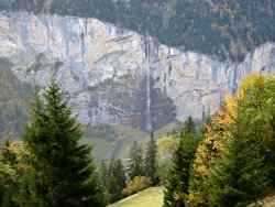
Waterfall across the valley
Not far after the scenically-positioned lookout bench, a signposted path leads down to the left towards Stalden and Wengen. Take this path, and the next right, again towards Wengen, descending steeply in zigzags with amazing vertical views of the Lauterbrunnen valley from Staldenflüh. The cliffs are incredibly sheer here, with the valley a good 800m below - don't lean over if you don't like heights! The path levels out to reach Schiltwald after around 1h20.
Not far after Schiltwald, a signposted track leads steadily downhill towards Lauterbrunnen, or the route to Wengen continues straight ahead. Following a quiet, level road along the side of the valley, you reach the station at Wengen after around 25 minutes, right at the end of the main street. The tourist office is on this main road on the left.
The last stretch of this day's walk, down to Lauterbrunnen, is an easy, if knee-straining, descent of almost 500m. Follow the signs under the railway bridge and drop down to the right. It's clearly signposted, with zigzagging paths and tracks, passing through Dornimad to the edge of Lauterbrunnen. After a scenic diversion round the concrete monstrosity of a car park, you reach the station after around 50-60 minutes.
Then you can start looking forward to the next stage, over the Sefinenfurgge.
The following are the coordinates for waypoints along this route, obtained from GPS. They can be used either in another GPS, or along with a map, to provide additional references if necessary.
                           Latitude       Longitude    Altitude(m)
       Grindelwald Stn    N 46°37'27.2    E008°02'02.6    1034
       Grund              N 46°37'18.5    E008°01'25.8     943
       Brandegg           N 46°36'31.1    E008°00'38.3    1340
       Alpiglen           N 46°36'00.9    E008°00'15.5    1614
       Kleine Scheidegg   N 46°35'07.3    E007°57'41.1    2061
       Haaregg            N 46°34'22.9    E007°57'35.8    1990
       Weisse Fluh        N 46°34'18.7    E007°56'54.9    1835
       Mettlenalp         N 46°34'18.7    E007°55'54.7    1725
       Lookout            N 46°34'22.6    E007°55'25.0    1700
       Stalden            N 46°34'32.1    E007°55'12.4    1665
       Schiltwald         N 46°35'31.9    E007°55'20.1    1310
       Wengen Stn         N 46°36'17.5    E007°55'15.4    1274
       Dornimad           N 46°35'51.3    E007°54'46.3     849
       Lauterbrunnen Stn  N 46°35'53.7    E007°54'28.5     829
For local information, see wengen-muerren.ch and grindelwald.com. A good overview drawing of the Grindelwald area is at jungfraubahn.ch under English-> Jungfrau Region-> Maps. Other walks in this area include Around Wengen, Under the Eiger, and Over the Faulhorn. Or if you're here looking for snow, you can also go snowboarding at Grindelwald First or Männlichen / Kleine Scheidegg.