
Hike time: | 4 to 4.5 hours |
Approx dist: | 16 km |
Start: | Sunnegga funicular station |
Finish: | Zermatt |
Season: | Summer |
Profile: | from 2290m up to 2540m, and back down to 1630m |
Rating: | mostly medium difficulty, but quite long |
Greeting: | "Grüsse" |
This popular route winds around the side valleys near Zermatt, with almost constant views of the Matterhorn. Starting from the top of the (underground) funicular to Sunnegga, the height gain is fairly minimal, and the views from the many lakes on the way are spectacular. Bonuses include hosts of wildflowers and butterflies, elusive marmots, and a posh restaurant at Riffelalp.
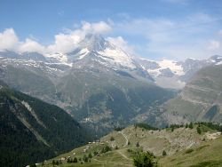 Panoramic view from Sunnegga towards Matterhorn 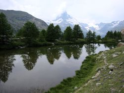 Grindjisee with Matterhorn beyond 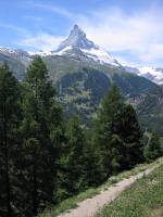 Path with view of Matterhorn |
The only way to get to Zermatt is by train, those with a car must leave it at the village of Täsch a short distance down the valley, and join the train there. Trains run hourly from Brig through Visp, on a cogwheel track that is not covered by the normal GA or Tageskarte tickets.
From Zurich, it's a 3 hour 15 minute trip changing at Visp, which is much shorter than it used to be before the longer Lötschberg tunnel was opened. So instead of going through the Kandersteg tunnel and going down to Brig, the train hurtles through the dark tunnel to Visp instead. A return ticket currently costs CHF 104 with half-price card.
For a zoomable, scrollable map of this hike, see this online map using Openstreetmap or Opencyclemap.
You can also download this kmz file zermatt.kmz to open it in programs like Google Earth or GpsPrune and then transfer the track to your GPS.
Sunnegga - Stelllisee - Grindjisee - Grünsee - Riffelalp - Moos - Zermatt
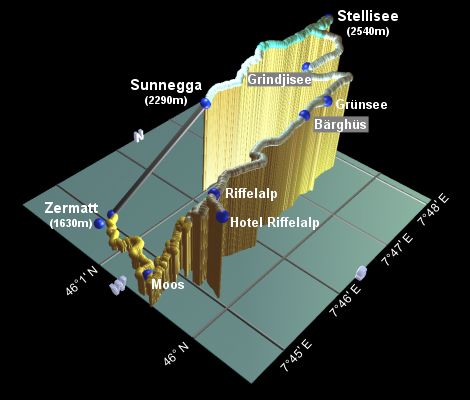 |
The impressive cable train rushes up the tunnel to Sunnegga, giving over 650m of elevation. From here the views across to the Matterhorn are already stunning, as the whole scale of the area is immense. The vertical distance between the peaks and the valleys is enormous. A short path leads down to a lookout point, from which the whole panorama can be enjoyed.
Back at the funicular station, follow the signpost towards the Stellisee, leading uphill underneath the Blauherd gondola line. The well-kept footpath climbs steadily through prime marmot country, before swinging round to the right and levelling off at just over 2500m. Keep following the signs towards the Stellisee, to reach the postcard-perfect lake after around 1h10. [Note: beware of bizarre sculpture thingies here until 17th August - according to the paper, some artist has been running amok with hundreds of life-sized statues made of litter - so-called Müllmenschen.]
After soaking in the tranquil and serene atmosphere, and after waiting patiently for the cloud to clear just a little bit from the Matterhorn summit and for the wind to drop so you can see the reflection clearly, tear yourself away and return on the path back to the last junction. This leads downhill to the left, signposted Grindjisee, leading to a broad, gently-descending track. The lake itself lies off to the right of the track after around half an hour, with a stepping-stone path leading down for the photo opportunities.
The track shortly doubles back to the left, and cuts deeply into the valley, before crossing a bridge and returning to the Eastward course on the level. Yet another lake, the Grünsee, lies off to the left of the path after another half hour, and is well worth making the short detour for. This walk is certainly not lacking in suitable picnic sites.
Continuing towards Riffelalp, the path heads past the (closed in June) Bärghüs Grünsee, before heading through the trees along the side of the valley. Taking the fork signposted towards the station, you reach this after around an hour, on the line between Zermatt and Gornergrat. This provides an alternative route back down if the 600m of descent by foot doesn't appeal. But before you do, it's worth taking the easy 10-minute stroll to the Hotel Riffelalp, following the oh-so-cute novelty railway to the superbly-positioned hotel and restaurant.
Back at the Riffelalp station, there are a couple of possible footpaths back down to Zermatt, the shorter of which is fairly steep and perhaps not as recommended as the longer route via Moos. This way, signposted from the station, winds down in switchbacks through the steep forest, emerging at Moos after around 1h10, and taking another half hour to gently stroll back into Zermatt past the Furi gondola line.
The following are the coordinates for waypoints along this route, obtained from GPS. They can be used either in another
GPS, or along with a map, to provide additional references if necessary.
                           Latitude       Longitude    Altitude(m)
       Zermatt station    N 46°01'19.7    E007°44'52.6    1628
       Funicular base     N 46°01'20.9    E007°45'06.1    1611
       Sunnegga           N 46°01'01.2    E007°46'13.1    2288
       Stellisee          N 46°00'48.9    E007°48'07.7    2538
       Grindjisee         N 46°00'41.7    E007°47'31.3    2351
       Grünsee            N 46°00'19.6    E007°47'11.9    2308
       Bärghüs Grünsee    N 46°00'20.3    E007°46'46.7    2307
       Riffelalp          N 46°00'18.2    E007°45'13.6    2227
       Hotel Riffelalp    N 46°00'07.1    E007°45'03.2    2227
       Moos               N 46°00'31.2    E007°44'34.7    1752
zermatt.ch has lots of information about the area, including hiking suggestions and a panoramic map.
For snow-related fun in this area, again with stunning views of the Matterhorn and the surrounding glaciers, see snowboarding in Zermatt.