
Hike time: | 8 hours |
Start: | Niederrickenbach Dorf |
Finish: | Engelberg |
Season: | Summer |
Profile: | from 1050m over a 1360m ridge down to 890m, then over a 1730m ridge down to 1020m |
Rating: | difficult and long, with lots of climbing |
The Benediktusweg explores the ridges above the Engelberg valley, climbing over two of them to gain good views North towards Lake Luzern and South towards Titlis. Along the way (which is long and tricky), the trail passes through woodland and farmland, and underneath the impossibly craggy Walenstocke.
Be prepared for tricky underfoot conditions, including tree roots and rocks, on the narrow trails, and for erratic, occasionally elusive signposting.
The start of the walk is at Niederrickenbach Dorf, at the top of the cable car from Niederrickenbach LSE, down in the valley. As the name suggests, Niederrickenbach LSE is on the Luzern-Stans-Engelberg line with regular trains. To get there from Zurich, take the train to Luzern (50 mins), then on the red LSE train to Niederrickenbach LSE (30 mins), and then the cable car (when it's running) up to Niederrickenbach Dorf.
The return journey is the LSE train back to Luzern, and the train from there back to Zurich. Total cost with halb-tax: CHF 35.
Niederrickenbach Dorf - Alpboden - Plütschgen - Oberrickenbach - Eggeligrat - Stock - Engelberg
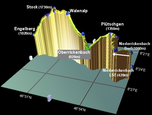 |
3D plot of the Benediktusweg hike, |
The picture here shows a plot of the hike, going Southwards from right to left. The heights are colour-coded, yellow being above 1500m, light green above 1000m and dark green below 1000m.
Niederrickenbach Dorf is a beautifully situated rural village, with a picturesque church high above the cloud-filled valley below. The peaks of Haldigrat and Bristis tower above, but the valley stretches back towards Luzern far below. On the road behind the church, a signpost leads you South on the 'Benediktusweg' on a level and very pleasant meander. Keep following these signs until you reach the lower chairlift station at Alpboden, at which point the path splits. Note the hand-painted signs, and take the trail to the right, climbing up alongside the chairlift and bearing round to the right through the trees.
Keep following the posts, painted rocks and marked trees upwards, to eventually reach the peak of Plütschgen. The views back down into the valley make this stretch particularly scenic.
Now the trail starts to descend, sometimes marked "Nidwaldnerweg", into the clearly visible village of Oberrickenbach, which looks an awful long way down considering the inevitable climb back up the other side! It also is a wonderfully situated village, with towering peaks behind the spired church. It's also got some cafes and an all-important drinking fountain to refill those bottles.
The 'Benediktusweg' signs lead across the village and down to the stream, crossing it before zig-zagging up the steep valley wall. Reaching a narrow ridge, the gradient eases a little, as the trail follows the ridgetop to Eggeligrat. The trail then rises sharply up through rocky farmland, with horses, goats and cows providing the bell-ringing accompaniment. In fact, to call it a trail is a slight exaggeration, it's just a general heading across the slope at this point. After climbing up the right-hand edge, the rocky mass of the peaks above come into view, culminating finally in awesome views of the Walenstock. Then the trail drops slightly, past more very inquisitive cows! before making the last small climb up to Stock. From this section the views across the valley to Titlis are very impressive.
From here, it's all downhill, dropping past Chruteren and following the signs for Engelberg (if the view of the town and the looming Titlis aren't clues enough). Eventually the trail hits small roads at the top end of Engelberg, and it's not much farther on downhill to the centre (the signposts stop but it's all just downhill). At the main road, turn right and look out for the station over to your left after a few minutes.
The following are the coordinates for waypoints along this route, obtained from GPS. They can be used either in another GPS, or along with a map, to provide additional references if necessary.
                        Latitude       Longitude       Altitude (m)
Niederrickenbach LSE    N 46°55.697'   E008°23.744'     420
Niederrickenbach Dorf   N 46°55.756'   E008°25.575'    1057
Alpboden chairlift      N 46°55.087'   E008°26.393'    1191
Signpost                N 46°54.971'   E008°25.282'    1317
Plütschgen              N 46°54.601'   E008°24.935'    1346
Oberrickenbach          N 46°53.302'   E008°25.056'     916
Eggeligrat              N 46°52.829'   E008°24.531'    1233
Walenalp                N 46°51.807'   E008°24.025'    1645
Stafel                  N 46°50.960'   E008°24.083'    1700
Stock                   N 46°50.799'   E008°23.711'    1729
Chruteren               N 46°50.461'   E008°24.130'    1586
Engelberg Station       N 46°49.190'   E008°24.157'    1023
Instead of starting at Niederrickenbach, it is also possible to get a post bus to Oberrickenbach from Wolfenschiessen (on the LSE line), thereby cutting out one of the ridges. It's also possible to walk to Ristis instead of Engelberg, and take the cable car down to Engelberg from there.
There is a route map on the lakeluzern.ch site, under English - Excursions/Sports - Engelberg - Benediktusweg, and a panoramic map of the whole area on the tell-pass.ch site.