
Hike time: | 4 hours |
Approx dist: | 8 km |
Start: | Rabaçal |
Finish: | Rabaçal |
Profile: | from 1070m down to 840m, and back again |
Rating: | Easy |
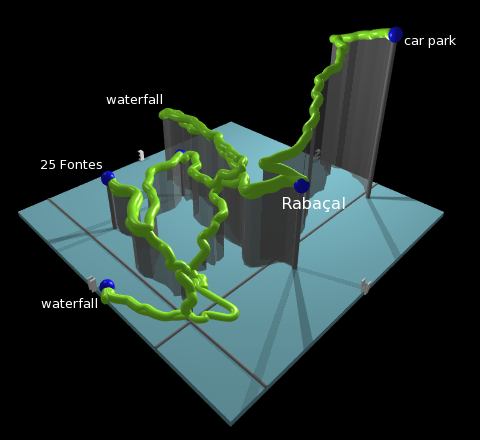
This walk is not really a loop and not really a there-and-back walk, but more of a star-shaped affair, with tentacles reaching out along the many different levadas around Rabaçal.
The first destination is the waterfall, which makes a very impressive sight from below. Then the route backtracks and explores the next levada, looping round to the pool of the "25 springs". Finally it heads further north to another waterfall, before warning signs prevented any further exploration. So it follows a different route back south to climb back up to Rabaçal.
 Waterfall trickling from the steep cliffs 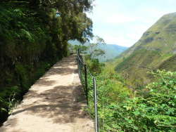 Levada and grand scenery 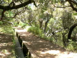 Tranquil shady levada 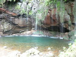 springs feeding the turquoise pool |
It's no longer possible to drive all the way to Rabaçal - the steep and narrow road down to Rabaçal has been sensibly closed to everyone except the regular shuttle bus. There's plenty of parking space by the main road, and then you can either choose to walk down to Rabaçal (2km, 220m descent) or pay for the bus ride.
At the end of the hike, the bus ride is slightly more expensive (3 euros up, 2 euros down per person) but may be worth it for you to save the 220m climb back up to the car park.
This kmz file (4 kb) contains waypoints from this Rabaçal hike and shows the path as a red line around the levadas. Simply open it in Google Earth (File -> Open) and you'll see the route in full. Press the "Play Tour" button below the listed waypoints and you can fly a tour along the hike in 3d.
Rabaçal - waterfall - bridge - 25 springs - waterfall2 - Rabaçal
 |
If you start from the car park at the main road, it's a leisurely downhill stroll down the road to Rabaçal before you reach the levadas. It's a narrow road but the only traffic is the occasional shuttle bus. Even with stops to admire the views over the valley, you reach Rabaçal in around half an hour, which is probably about as long as waiting for the bus anyway.
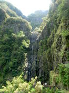
From Rabaçal, the first port of call on this walk is the Cascata do Risco (dangerous waterfall?). Turn right along the levada and the waterfall is already signposted. The path is flat and easy, and follows the winding levada as it bends round to the right. When the path splits, continue onwards on the upper, right-hand path still signposted for the cascata do risco.
Shortly the levada rounds the corner of the hillside and the first waterfall comes into view - a massive cliff like something out of the lost world, with lush greenery clinging to the rocks. The water flow is lower in summer but there is still an impressive cascade coming down.
Unfortunately the path ends here, so you'll need to retrace your steps at least as far as the fork. Here we turn right and head down a long set of steps to reach a second levada, heading towards "25 fontes" (25 springs). We turn right to follow the levada upstream, and thereby get an additional perspective on the waterfall - we can see where we were earlier above us to our right.
We cross the wooden bridge and curve around the valley side to our left, all the time following the smoothly flowing levada, but now heading northwest. Finally we take the signposted right turn and follow the path up to 25 fontes, where there is a beautiful blue/green pool feed by countless cascading water trickles. It's not obvious where they got the number 25 from, but that doesn't matter - it's a great place to rest with a picnic and listen to the water.
The next section of this walk again retraces its steps for 10 minutes or so but then continues westwards down a narrow unmarked path through the trees. This winds its way down switchbacks to meet yet another levada, this one called the levada da rocha vermelha. We turn right here to follow the levada northeastwards, but are unfortunately soon blocked by a 'closed' sign due to footpath damage and the danger of falling rocks. Instead we admire the small waterfall here and return back along the levada to where we joined it.
Instead of returning up our narrow path, we continue along the levada and soon see the start of the hike high above us. When the levada enters a short tunnel, don't go through this but bear left uphill and climb in zigzags to meet our second levada. From here we can return up the long set of steps to the levada do risco and return to Rabaçal.
The following are the coordinates for waypoints along this route, obtained from GPS. They can be used either in another
GPS, or along with a map, to provide additional references if necessary.
                           Latitude       Longitude    Altitude(m)
       Car park           N 32°45'17.0    W017°08'01.5    1291
       Rabacal            N 32°45'41.9    W017°08'04.0    1065
       Bridge             N 32°45'41.3    W017°07'31.3     971
       25 Springs         N 32°45'56.0    W017°07'30.8     993
       Waterfall          N 32°46'04.6    W017°07'44.1     848
There's a very short description of this walk and several colourful photos at sanmarko.nl.