
Hike time: | around 52 days |
Approx dist: | 1000 km (620 miles) |
Start: | Minehead, Somerset |
Finish: | South Haven Point, Poole |
Profile: | between sea level and 320m |
Hilliness: | Astonishing 35 km climb, 35 km descent |
The South West Coast Path is a hugely-long footpath in England, running (as its name suggests) around the south-western coast. Starting from Minehead, in Somerset, it runs anti-clockwise around Devon and Cornwall, to finish in Poole Harbour. Despite following the coast, the vertical climb and descent are impressive, covering almost 4 Everests up and down (115 thousand feet of climb, and the same amount of descent!). However, the trail is extremely long too, so the overall hilliness "only" reaches 330 milliEverests per marathon.
In various places, there is a choice of route, but these sections are short and don't make too much difference. It's possible that certain areas are temporarily closed due to firing ranges being operational, in which case diversions should be signposted.
The route follows long stretches along remote coastline, so it's not always easy to plan public transport routes outside the main towns. One option is to plan circular tours where the coastline is not so linear, such as in Cornwall or on the Isle of Portland. Or research the local bus routes for individual sections.
Also note that there are a few short ferry sections which are more or less required. It would be very advisable to check the running times of these ferries before setting off, to avoid surprises.
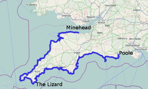 |
Minehead - Ilfracombe - Bude - Newquay - Hayle - Penzance - The Lizard - Penryn - St Austell - Plymouth - Dartmouth - Exmouth - Lyme Regis - Isle of Portland - Weymouth - Lulworth Cove - Swanage - South Haven Point (Poole)
The following is an example of how to split up the route, offered by the southwestcoastpath.com website. Distances and altitudes are approximate and obtained from the official published coordinates together with SRTM data.
Note that some might find days of up to 26 km somewhat tiring, and depending on where exactly you find your accommodation your stages may be slightly longer. So you may want to split up these stages even more than described here.
So, starting from Minehead, ...
| Stage Goal | Distance | Climb | Descent | Stage Goal | Distance | Climb | Descent | |||
| 1 | Porlock Weir |
14.1 km |
400 m |
400 m |
27 | Coverack |
16.3 km |
700 m |
700 m |
|
| 2 | Lynmouth / Lynton |
18.5 km |
1100 m |
1100 m |
28 | Helford |
21.1 km |
600 m |
600 m |
|
| 3 | Combe Martin |
21.9 km |
1250 m |
1250 m |
29 | Falmouth |
16.0 km |
400 m |
400 m |
|
| 4 | Woolacombe |
21.9 km |
950 m |
950 m |
30 | Portloe |
21.0 km |
700 m |
700 m |
|
| 5 | Braunton |
23.9 km |
350 m |
350 m |
31 | Mevagissey |
19.2 km |
800 m |
800 m |
|
| 6 | Instow |
18.4 km |
50 m |
50 m |
32 | Par |
17.2 km |
650 m |
650 m |
|
| 7 | Westward Ho! |
20.1 km |
200 m |
200 m |
33 | Polperro |
22.8 km |
850 m |
800 m |
|
| 8 | Clovelly |
17.4 km |
900 m |
800 m |
34 | Portwrinkle |
20.6 km |
800 m |
800 m |
|
| 9 | Hartland Quay |
16.3 km |
950 m |
1050 m |
35 | Plymouth |
20.5 km |
700 m |
750 m |
|
| 10 | Bude |
23.7 km |
1250 m |
1250 m |
36 | Wembury Point |
24.9 km |
550 m |
550 m |
|
| 11 | Crackington Haven |
16.0 km |
700 m |
700 m |
37 | Bigbury on Sea |
21.9 km |
750 m |
750 m |
|
| 12 | Tintagel |
17.8 km |
950 m |
950 m |
38 | Salcombe |
20.7 km |
700 m |
700 m |
|
| 13 | Port Isaac |
14.6 km |
900 m |
900 m |
39 | Torcross |
20.1 km |
750 m |
750 m |
|
| 14 | Padstow |
19.5 km |
700 m |
700 m |
40 | Dartmouth |
15.9 km |
550 m |
550 m |
|
| 15 | Porthcothan |
21.3 km |
500 m |
500 m |
41 | Brixham |
16.9 km |
900 m |
900 m |
|
| 16 | Newquay |
17.0 km |
550 m |
550 m |
42 | Babbacombe |
21.9 km |
700 m |
650 m |
|
| 17 | Perranporth |
18.8 km |
450 m |
500 m |
43 | Exmouth |
21.9 km |
750 m |
800 m |
|
| 18 | Portreath |
19.1 km |
850 m |
850 m |
45 | Sidmouth |
21.1 km |
600 m |
550 m |
|
| 19 | Hayle |
19.0 km |
500 m |
500 m |
46 | Seaton |
15.6 km |
800 m |
850 m |
|
| 20 | St Ives |
11.0 km |
250 m |
250 m |
47 | Seatown |
22.6 km |
950 m |
950 m |
|
| 21 | Pendeen |
19.4 km |
900 m |
850 m |
48 | Abbotsbury |
19.7 km |
350 m |
350 m |
|
| 22 | Sennen Cove |
14.3 km |
500 m |
500 m |
49 | Ferrybridge |
17.0 km |
250 m |
250 m |
|
| 23 | Lamorna |
18.6 km |
750 m |
750 m |
50 | Isle of Portland |
21.4 km |
450 m |
450 m |
|
| 24 | Marazion |
15.4 km |
250 m |
250 m |
51 | Lulworth Cove |
23.3 km |
700 m |
700 m |
|
| 25 | Porthleven |
15.8 km |
550 m |
600 m |
52 | Worth Matravers |
18.6 km |
850 m |
800 m |
|
| 26 | The Lizard |
22.1 km |
750 m |
750 m |
53 | South Haven Point |
26.3 km |
600 m |
700 m |
(The additional stage 44 is an alternative shortcut along the South Dorset Ridgeway, quite a way from the coast).
The page at nationaltrail.co.uk diverts immediately to southwestcoastpath.com where detailed information including descriptions of each stage and kml downloads can be found. There's also a small amount of information at Wikipedia.
The route is also available in OpenStreetMap, stored as a super-relation 2376086 with each of the 52 stages as separate relations within. So for example you can use JOSM to download the OpenStreetMap coordinates given the relation ids.