
Hike time: | 3.5 hours |
Approx dist: | 8 km |
Start/Finish: | Quiraing car park |
Profile: | from 260m up to 530m, and back again |
Rating: | Medium trails with some stream crossings and a slippy descent |
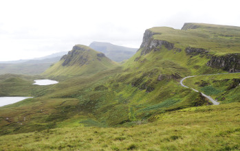
Quiraing is a famous rock formation in the north of Skye. Not really a mountain with a clearly defined peak, it's more of a really interesting landscape which is perfect for exploring. Ascending to the summit is optional for many, as just being within the folds and contours of the dramatic formation is an experience itself.
 Near the start of the hike above the car park 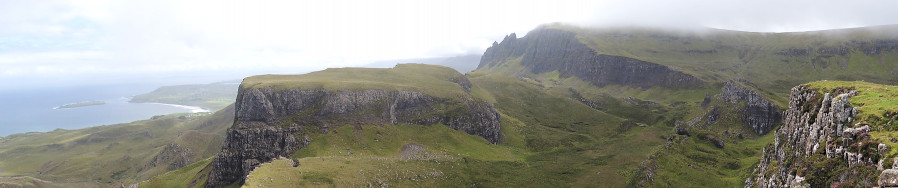 Coastline of Skye 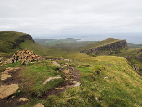 Near the summit |
The walk starts and ends at the expansive Quiraing car park. You probably need your own vehicle to get there, as there doesn't seem to be any public transport here (tourist coaches stop here though). Many people don't get more than a hundred metres or so from the car park.
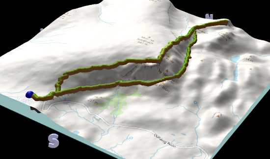
Car park - lookout - summit - car park
 |
and back on the higher path |
The adventure starts with an exciting, climbing, winding road trip up to the car park, either from Staffin in the east or from Uig in the west. The start of the hike (the blue dot on the plot to the right) feels really mountainous even though it's less than 300 m above sea level.
Once you get away from the car park crowd, the path gains height only very slowly, and is for the most part fairly easy, straight and level. Only when one of the streams crosses the path does it get a bit rocky and you may have to use your hands a bit to avoid getting your feet wet. Some of the dogs and even some of the humans got a bit nervous on these places.
After less than 100 m of climb you find yourself already at the junction, at which point you can consider your options. Back the same way is one option, and the views are different coming the other way. Onward to a lookout point is the second option, and it's just around 10 minutes further on, with airy views of the coastline and rewarding views back to the landscape you've come through. And option three is to take the well-trodden path up alongside the cliff to get some more high-altitude views and a different way back to the car park.
Of course "high altitude" is relative, but even from only 530 m above sea level everything here looks dramatic, especially so close to the sea. The upper route does, however, get rather wet and boggy, even in dry weather. That's not so much of a problem on the ascent, or even on the broad, flat summit, but when the path starts to descend it can get slippy.
Erosion is also a serious problem on this descent, and one wonders how long it'll be before the sprawling network of tracks make it necessary to implement some kind of erosion control. Currently the damage and the slippiness is forcing hikers to diverge even further from the proper path, making the damage even more extensive, which is a shame.
The landscape here is spectacular, of course, and the fact that you can modify this route to make it shorter or longer as you wish makes it one to recommend. By wet weather I would suggest avoiding the upper route.
The following are the coordinates for waypoints along this route, obtained from GPS. The paths are all clear apart from the final descent to the car park.
                           Latitude       Longitude    Altitude(m)
       Car park           N 53°37.68'     W 6°17.58'     260
       Junction           N 57°39.03'     W 6°16.69      340
       Lookout            N 53°39.28'     W 6°16.37'     380
       Summit             N 53°38.53'     W 6°16.55'     531
See Wikipedia's page on Quiraing and Skye for more information, or see walkhighlands.co.uk.