
Hike time: | 5 hours |
Approx dist: | 7 km |
Start: | Iseler Bergstation |
Finish: | Iseler Talstation |
Season: | Summer |
Profile: | from 1560m up to 1900m and down to 1150m |
Rating: | tricky with rocky paths and narrow exposed ridges |
Greetings: | "Guten Tag", "Hallo" |
Map link: |
East of Sonthofen, right on the border with Austria, is the mountain of Iseler above Bad Hinderlang. In the Winter it's obviously a ski resort, and in the Summer a popular hiking area.
This adventurous hike starts off easy with the chairlift ride up to the top station (1560m), and has a straightforward 300m climb by foot to the summit of Iseler. However, then it follows a rocky path along the ridgetop, dropping and climbing along the border with Austria, before taking a hefty descent back down to the lower chairlift station and car park.
It's only 7 kilometres long but it takes a long time, as several sections require great care when choosing where to put your feet. The views from the ridgetop are spectacular and very rewarding, but only if you have a head for heights and good balance.
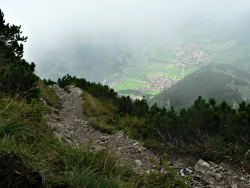 Narrow path up towards Iseler summit 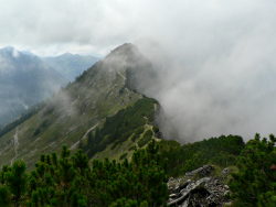 Dramatic ridgetop with mist 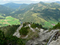 Descent into nothingness |
Private transport seems the only way to get here, either eastwards from Sonthofen up the winding road to Oberjoch, or southwards from the A7 through Oy. The Iseler lift is well signposted and the adjacent car park is free.
The chairlift up to the top costs currently 8 EUR per person, or 7.50 EUR if you have a local guest card.
This kmz file (4 kb) contains waypoints from this Iseler hike and shows the path as a red line around the ridgetop. Simply open it in Google Earth (File -> Open) and you'll see the route in full. Press the "Play Tour" button below the listed waypoints and you can fly a tour along the hike in 3d.
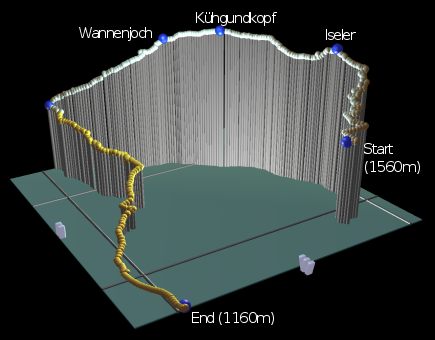
Iseler Bergstation - Iseler summit - Kühgundkopf - Wannenjoch - Smugglers path - Iseler Talstation
 |
From the top chairlift station, the path leads directly ahead and climbs in switchbacks towards the summit. The path is pretty straightforward but fairly narrow, and provides open views behind you on the climb. Around half-way up, the path splits but the left-hand path leads to the "Salewa Klettersteig", a climbing route which requires helmet and harness and other climbing equipment. Our path doubles-back to the right and continues the switchback climb, eventually curving round to the left towards the summit.
The summit of Iseler itself can be crowded on clear days, both with hikers and climbers, and children and dogs, but surprisingly this isn't the highest point on this hike. The ridge continues ahead, dropping steeply on a tricky path at first with rough steps and long hand cables, then levelling out with open views in both directions, before climbing again to the unmarked summit of Kügundkopf. Here you're right on the international border, with Germany on your left and Austria on your right. There's very little to indicate the border though, even as you follow it along the spectacular ridgetop.
The path descends now towards the lower summit of Wannenjoch, with several tricky exposed sections. Sometimes it feels like you're walking down the spine of a dragon, with nothing on either side and just the ridge dropping away in front of you.
From Wannenjoch, the path drops further with more tricky bits to negotiate, making it slow but spectacular going. The first major junction is where the smugglers' path (or Schmugglerpfad) crosses the ridgetop on its sneaky international route. Here is where we leave the border, dropping sharp left away from the ridgetop and back towards the bottom station of the Iselerbahn.
Away from the ridge, the path is much easier but softer and may be wet in places. There is a long section of rootiness, some of it slippy, and then you meet the top of a drag lift where the path splits. Follow the signs for Iseler Talstation, and then the path cuts left down to meet the tumbling stream which you have already heard. After crossing this stream, the path heads back out into the open, and then joins an easy track for the rest of the descent.
The track comes round some farm buildings out onto the main road, not far from the lower chairlift station. Just turn left and follow the main road, reaching the car park after around 600 metres.
The following are the coordinates for waypoints along this route, obtained from GPS. They can be used either in another GPS, or along with a map, to provide additional references if necessary.
                           Latitude       Longitude    Altitude(m)
       Iseler Bergstation N 47°30'07.7    E010°24'53.0    1559
       Iseler             N 47°29'58.6    E010°25'15.2    1875
       Kühgundkopf        N 47°30'13.6    E010°25'52.7    1903
       Wannenjoch         N 47°30'24.2    E010°26'07.1    1852
       Smugglers path     N 47°30'50.9    E010°26'26.7    1520
       Iseler Talstation  N 47°30'53.1    E010°24'40.6    1158
The Iseler Bergbahn site has an aerial photo of Iseler with the routes marked, and German descriptions. There is a German description and some great photos on the alpic.net forum.
You can also see the German wikipedia's page on Iseler, and for more general tourist information on the area, see Allgäu info.