
Hike time: | 6 hours |
Approx dist: | 17 km |
Start: | Tenero |
Finish: | Lavertezzo |
Season: | Most of Year |
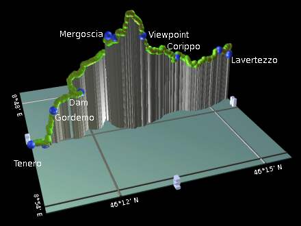
Profile: | from 200m up to 850m and down to 510m |
Rating: | mostly easy paths but strenuous in one day |
Greetings: | "Buon giorno", "Bonjour", "Grüezi" (lots of tourists!) |
Val Verzasca is a relatively remote, but popular dead-end valley not far from Locarno in Ticino. That means it's in the warm, low, palm-strewn south of Switzerland, and makes an ideal Springtime trip while the snows are still melting further north.
The attractions in this valley are partly natural, and partly man-made. One unique highlight could also be considered a concrete monstrosity, but the 220m high dam across the valley is undoubtedly a massively impressive engineering feat, and the bungee jumping which takes place from the top is a must for daredevil James Bond fans. And less daring spectators.
Apart from the dam, though, the valley also offers verdant scenery with a clear, emerald-green river, several intriguing and picturesque villages, and some easy walking paths. And lots of little lizards.
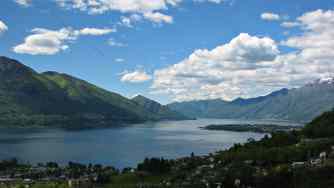 View of Lago Maggiore from above Tenero 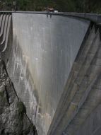 Impressive dam and jumping-off point 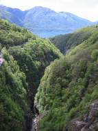 Looking down Val Verzasca from the dam 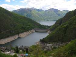 View down valley from Mergoscia 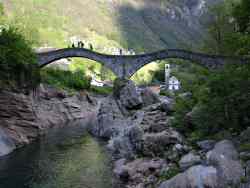 Old, double-arched bridge at Lavertezzo |
The access point for this walk is Tenero, which lies at the mouth of the Val Verzasca and has a train station on the line between Bellinzona and Locarno. There are regular (but not particularly frequent) bus services operating up and down the valley, making it easy to return to Tenero from wherever you finish, or to split the walk up into manageable sections.
From Zürich, this is better done as a weekend trip, with a direct train to Bellinzona and the connecting regional train (towards Locarno) from there to Tenero. A return to Tenero costs CHF 55 with halbtax, plus the single bus ticket on the way back.
For a zoomable, scrollable map of this hike, see this online map using Openstreetmap or Opencyclemap.
You can also download this kmz file val_verzasca.kmz to open it in programs like Google Earth or GpsPrune and then transfer the track to your GPS.
Tenero - Gordemo - dam - Busada - Mergoscia - Corippo - Origa di Fuori - Lavertezzo
 |
There are a few options to walk up the Val Verzasca, this recommendation comes from wandersite.ch, whose German description takes a somewhat up-and-down variant via Mergoscia to Lavertezzo. This has the advantage of crossing the dam and getting the views from Mergoscia before dropping back down to the river and finishing by the photogenic double-arched bridge. For other options, including shortening it or turning it into a multi-day walk, see the links below.
For most of this walk the singposting is excellent, but at the very start there's a bit of nose-following to be done. From the station, face Locarno and take the steps leading up to your right towards Tenero village. If you jink right and left, you come to the small village square, with a closed tourist information office and a welcome water tap. Head right along the main road until you reach the bridge across the river, where you'll eventually find the signposts leading you towards Gordemo.
The signs lead up stepped stone paths inbetween the gardens and the grape vines, with views back down towards Lago Maggiore. With arrows and red-and-white splashes, the route gains height steeply until a final twisty diversion through the vines and building works brings you out in Gordemo (or 'Cordemo').
With the lake laid out far below, follow the signs to "Sentierone Val Verzasca" through the village and out into a flatter, rockier path through the green forest. You can start to glimpse the dam ahead here, but it doesn't look too impressive yet because you're approaching it at the level of the top. Shortly the path meets a small road at a hairpin - turning right here would lead uphill on the alternative route through Vogorno before crossing the river further up, but here we're turning left and going downhill to take a closer look at that dam.
The downhill stretch lasts only a few minutes, before crossing the road and joining the other tourists at the dam. There's a car park here and an information centre, so it's a rare busy stretch on this walk. And the dam is certainly impressive, at over 200m high. The bungee jumpers have a small scaffolding platform at the centre from which to do their thang, but there was nothing going on at the time of writing. Book ahead if you're interested.
Cross the dam, and take the marked path leading initially down to the left but soon switchbacking back up again to meet the road between Contra and Mergoscia. Turn right here heading steadily uphill towards Mergoscia - although there's no footpath here there's little traffic. Shortly the cars are diverted into a tunnel and the old road is left for the pedestrians and cyclists,
Cutting leftwards deep into a side-valley, the road continues to climb and curves back round again, before joining the traffic re-emerging from the tunnel. Shortly however the signpost "Mergoscia-Busada" leads us up steps to the left, cutting up between the buildings to emerge at Busada, and a short distance further along the road, Mergoscia itself. From here the climbing is rewarded by superb views down valley to the dammed river and the Lago Maggiore beyond. A good stop for a picnic. There's also has a bus stop here if you've had enough for one day.
To the left of the church, steps lead upwards signposted "Corippo", climbing up through the village and heading rightwards along a narrow road. The footpath continues onwards from the end, climbing again, winding up through the forest to a high of around 850m before starting a somewhat steep and hairy descent. This leads to a viewpoint with a couple of benches and great views down to the river and further up-valley.
The path continues to descend through the forest, crossing a precipitous stone bridge over a side-stream, and then climbs up to the village of Corippo. This is another of the highlights of this walk, an atmospheric, intriguing and picturesque old village, full of tangling alleys to explore between the huddled houses.
From Corippo the route continues downwards, signposted for Lavertezzo, initially following the road and then a small path down to the right. As it emerges on the road next to the river, the alternative lower route through Vogorno joins it, having crossed the bridge over the now swift-flowing river. We then head upstream, the path leading past a weir and through the trees, until eventually Lavertezzo comes into view on the other side of the river. We however continue upstream past Lavertezzo, in order to cross the river by the narrow double-arched stone bridge seen on so many postcards. Here the formations of the rocks are stunning, with the stream channeled by massive blocks of different multi-coloured stones, each carved and sculpted by the relentless flow. This is an extremely popular spot for jumping from one stone to another, and photographing each other doing so.
Having crossed the surprisingly narrow bridge, it's just a few minutes' walk back downstream to Lavertezzo, from where the bus leaves around every two hours down to Tenero. The bus stop is just by the church tower.
The following are the coordinates for waypoints along this route, obtained from GPS. They can be used either in another GPS, or along with a map, to provide additional references if necessary.
                           Latitude       Longitude    Altitude(m)
       Tenero station     N 46°10'38.4    E008°51'05.0     205
       Ponte Tenero       N 46°10'55.9    E008°51'09.6     226
       Gordemo            N 46°11'11.3    E008°51'04.1     414
       Bungee jump        N 46°11'48.7    E008°50'54.2     473
       Busada             N 46°12'32.0    E008°50'35.5     735
       Mergoscia          N 46°12'38.7    E008°50'51.5     735
       Viewpoint          N 46°13'11.9    E008°51'01.5     738
       Corippo            N 46°14'08.4    E008°50'28.1     563
       Origa di Fuori     N 46°15'11.7    E008°50'29.8     562
       Lavertezzo bus     N 46°15'31.9    E008°50'18.5     515
This walk is described in excellent detail in German at wandersite.ch. There are rough maps of the valley at tenero-tourism.ch and map.search.ch, and a description of the walk (in German) at verzasca.com. There are also some photos of the valley at the home page of mcuniverse, and details about the bungee jumping (if you're crazy) at trekking.ch (but be prepared to cough up CHF 250 for the pleasure!).