
|
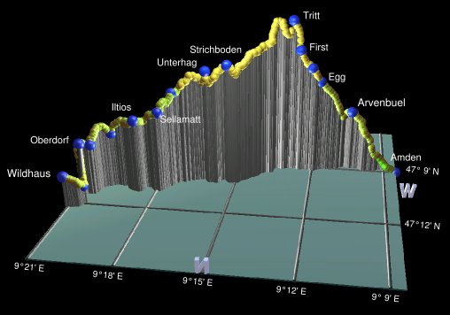
The Toggenburger Höhenweg takes a loopy route through some spectacular scenery east of Zürich, mostly in the canton of St Gallen. See the sg-wanderwege.ch page for an overview of the route. It starts off following the northern face of the Churfirstens range westwards towards Amden, before curving northwards past Speer and heading over Chrüzegg and the Schnebelhorn. Much of the area covered by this route is either geologically interesting areas, or preserved nature areas, or both, and the views are open and grand for much of the way.
There are plenty of possibilities for splitting the route into day sections, but in some sections, for example between Selamatt and Arvenbüel on the first day, there are neither overnighting possibilities nor convenient transport connections. The recommended way takes breaks at Arvenbüel, Tanzboden, Atzmännig and Mühlrüti, but this still leaves some fairly long days including one with 1200m of descent. And the public transport connections to and from Tanzboden are limited, meaning that it's better to start with a one-dayer or a three-dayer trip.
According to the maps, the Toggenburger Höhenweg really starts at Oberdorf, at the top of the chairlift above Wildhaus. The nearest bus station is Wildhaus Lisighaus, reached with a train to Nesslau-Neu St Johann and a bus from there. Other convenient access points include the bus between Ziegelbrücke and Amden Arvenbüel, the bus between Wattwil and Ricken, and the train station at the end of the route at Wil. See the official leaflet for more options.
From Zurich, it takes three changes to get to Wildhaus, with an S-Bahn to Rapperswil, a train to Wattwil, a train to Nesslau-Neu St Johann and a bus to Wildhaus Lisighaus. Getting back from Amden Arvenbüel at the end of day 1 should entail just a bus to Ziegelbrücke and a train, but as the Arvenbüel buses finish early (currently 6:20pm), you might have another hour's walk down to Amden to get the bus from there.
Tanzboden, at the end of day 2, hasn't got any convenient transport connections (the nearest is Ebnat-Kappel, 2 hours' walk away), but it does have the Bergrestaurant Tanzbodenalp which offers reasonable dormitory accommodation. At the end of day 3, Ricken has buses to Jona from where S-bahns connect to Zurich. Unfortunately getting back to Ricken from Zürich is made awkward by the fact that the tickets from the machine don't match the recommended route, so the bus driver complains about needing a surcharge. It might be best to get the ticket from the counter and explicitly mention the desired route.
Mühlrüti has buses to and from Bütschwil which has connections via Wil. Wil has regular train connections to Winterthur and Zürich.
For a zoomable, scrollable map of this hike, see this online map using Openstreetmap or Opencyclemap.
You can also download this kmz file toggenburger_hoehenweg.kmz to open it in programs like Google Earth or GpsPrune and then transfer the track to your GPS.
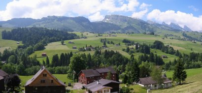 View from Wildhaus to the start of the Höhenweg 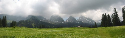 The north side of the Churfirstens 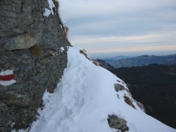 Don't worry, there's a safety cable 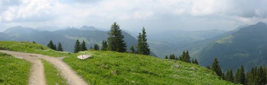 Open panorama to the north |
Hike time: | 6.5 to 7 hours |
Approx dist: | 22 km |
Start: | Wildhaus Lysighaus |
Finish: | Amden Arvenbüel |
Profile: | From 1000m up to 1810m, then down to 1260m |
Rating: | Mostly easy except for short tricky bits (steep rocky steps, handrails) but long |
Wildhaus Lisighaus - Oberdorf - Iltios - Sellamatt - Selunalp - Tritt - First - Amden Arvenbüel
See the map linked below for this first day. You can start from the centre of Wildhaus (or the bus stop Wildhaus Lisighaus) and follow the signposts (number 48) down to the chairlift station from there. The top of the chairlift is at Oberdorf, reached either by queueing for the chairlift or taking the pleasant footpath uphill for around half an hour.
Reaching the top chairlift station, with open views out across the valley to the Säntis range directly opposite, take the level road straight ahead signposted (as it will be all day) for the "Toggenburger Höhenweg", towards the Gamsalp lift. Continue on this road gently downhill as it passes through idyllic, scenic agricultural land towards Iltios.
At the Hägis signpost, leave the road on a path to the left, again signposted for the Höhenweg, and climb up following the trail called the "Klangweg", with various sound-related diversions, like percussion sculptures and wooden chimes. Don't miss the drums drilled into the side of the rock! The Klangmühle inside the cow-stall is also interesting. This trail leads directly to the Iltios station, and it looks like they're building more installations past Iltios too.
 |
Continue on the signposted path towards Sellamatt, which becomes a paved path through the forest. The tooth-like Churfirstens loom ever closer as the trail continues to steadily climb. Beyond Sellamatt you leave the ski resort and its transportation options behind, and enter a less domesticated area altogether. Still climbing, but now on grassier paths, and passing through marshier, more rugged terrain, you get a sudden, close-up view of the Churfirstens looming above. The signposts at Mittelstofel appear to split, attempting to lead you leftwards into the marsh, but keep to the clear path to the right instead and continue to Loch. There are a few stony and steep bits here as you climb up switchbacks over the small ridge, but you're soon at Unterhag with views out in all directions.
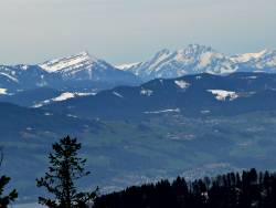
From here the radio mast at Strichboden is clearly visible ahead, marking the way for us. Beyond it to the north lie several sharp peaks receding into the haze. Our path curves round to the left, now more level, and passes by the mast and a small restaurant at Strichboden West. From here the path again becomes narrower and trickier as it climbs up steep rocky switchbacks over one ridge, before dropping to climb up to the highest point of the day at Tritt (1830m). From here there are great views encompassing several convoluted peaks and ridges, but our onward journey past Speer is still obscured by the Mattstock ridge above Amden.
Now begins the long descent, initially rather tricky with some welcome cables to hold on to, and then a steep
grassy descent down to the ridge below. Shortly the path reaches Looch with its small café and continues
on a wide track down to Egg. It's then just straight ahead following the Arvenbüel signs to the bus stop
at Arvenbüel. Here there are several overnighting options (see the pdf guide linked below or
amden.ch for suggestions), buses to Ziegelbrücke (if you make it before
they stop running), or around an hour's walk downhill to Amden for the later buses.
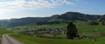
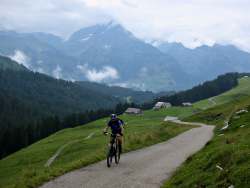 Climbing up from Arvenbüel 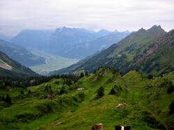 Oberchäseren 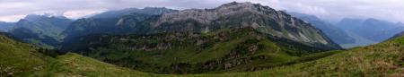 Sheer terrain of the Mattstock 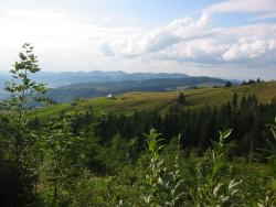 Gentler terrain towards Tanzboden |
Hike time: | 6 hours |
Approx dist: | 19 km |
Start: | Amden Arvenbüel |
Finish: | Tanzboden |
Profile: | From 1280m up to 1760m, then down to 1440m |
Rating: | Easy to medium |
Amden Arvenbüel - Hinter Höhi - Vordermatt - Oberchäseren - Stelli - Mült - Schilt - Butz - Usser Gheist - Tanzboden
From the bus stop in Arvenbüel (sometimes signposted as Arfenbühl), follow the road leading uphill through the village signposted for the Toggenburger Höhenweg and Hinter Höhi. The road rises steadily towards Vorder Höhi before our route leaves it with a sharp left turn onto a rising grassy path, Continue through cow pastures past Furgglen (with restaurant), enjoying opening panoramas down towards Amden. This whole stretch is a very scenic Höhenweg, descending gently towards Hinter Höhi where we join the Speer hike.
Follow the signs for Speer around the Mattstock on a broad rising track, with views back towards Säntis. At Vordermatt the path begins to gain height in earnest, climbing steeply up the valley to Oberchäseren. The sheer rock face of the Mattstock now dominates the views. Shortly you reach the crest of the hill and the restaurant at Oberchäseren, with a spectacular position overlooking the Linth plain between the Zürichsee and Walensee, and surrounded by sharp jagged peaks and ridges.
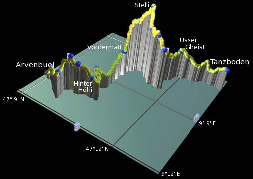 |
Continue up towards Speer, because even though our path is heading round the right-hand side of the summit, it climbs up as far as Stelli just below the peak before dropping down to the right. The descent is steep at first but shortly eases and curves around the block-like peak of Speer. After surmounting a small ridge the views open out to the flatland, before you drop down to Ellisalp and turn left towards Usser Gheist.
After climbing up to Usser Gheist you get the first views of the Zürichsee, but the panorama is indeed wide - from here you can also see Säntis, the Churfirstens (from the previous day's hike), the Glarus peaks and all the way round to the Zürcher Oberland.
Continue to follow the signs for the Toggenburger Höhenweg and Tanzboden, and descend steadily accompanied by the
panoramas. As you reach Tanzboden, the first hut you see is a ski hut belonging to the SAC, perched on an elevated position
with spectacular views towards the lake. A little further on is the Bergrestaurant Tanzbodenalp, just over the brow of the
hill but also with an enviable position.
 Tanzboden with views towards Säntis 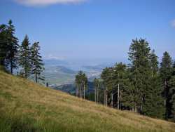 Descending with views of the Zürichsee 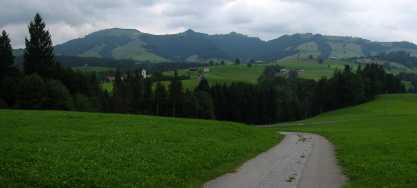 Nearing Ricken with the next day's ridge beyond |
Hike time: | 3 to 3.5 hours |
Approx dist: | 10 km |
Start: | Tanzboden |
Finish: | Ricken |
Profile: | From 1440m down to 790m |
Rating: | Easy |
Tanzboden - Stotzweid - Ober Bächen - Cholertoni - Stosslegi - Ricken
This is taken here as a short day, just 10km and mostly downhill to Ricken. The route recommended by sg-wanderwege continues on to Atzmännig at the top of the next ridge, but the transport connections to and from Ricken are easier (Atzmännig requires a chairlift down to Schutt and a bus from there), so we'll have a short leisurely day and get the bus from Ricken instead. There's just something uncomfortable about climbing 3 hours up a ridge at the end of the day just in order to take a chairlift back down again. And it makes the start of day 4 a bit easier, not having to take the chairlift up from Schutt to start the walk again. An alternative might be to push on beyond Atzmännig and stay the night at Chrüzegg, but for a two-day trip we need transport connections and Chrüzegg hasn't got any.
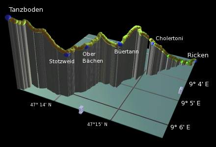 |
From Berghaus Tanzbodenalp, follow the signposted path gently downhill, shortly heading down between the trees. Passing through Stotzweid, you're treated to super panoramas on both sides, with Säntis on your right and the Zürichsee on your left. The route heads through cow pastures towards the now much less wild-looking terrain of the Zürcher Oberland.
Pass the restaurant at Ober Bächen (with its unfriendly dog), and over a small ridge to Büertann. Then the route begins to climb again, reaching a higher ridgetop with marvellous views in every direction.
From this ridgetop, don't take the broad straight path down towards the Zürichsee, but keep to the right along the stone wall on the much fainter path. This breaks off rightwards into the forest and drops steeply down to Cholertoni. Continue through the forest steadily downhill to Stosslegi, following the paths and tracks down towards Ricken. After crossing a bridge over the river, our route follows a narrow road into Ricken to meet the main road.
The signposts lead rightwards for Atzmännig and the next part of the Toggenburger Höhenweg, but the bus stop is a short
distance over to the left on a side road, outside the post office. Buses leave from here to Jona with many regional train
connections.
 From near Atzmännig towards the Zürisee 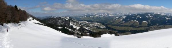 Looking back down towards Ricken 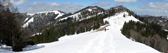 Round the ridgetop towards Chrüzegg 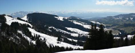 Another panorama towards the Zürisee |
Hike time: | 3.5 to 4 hours |
Approx dist: | 8 km |
Start: | Ricken |
Finish: | Chrüzegg |
Profile: | From 790m up to 1290m |
Rating: | Medium |
Ricken - Bodenwis - Hüttenberg - Atzmännig - Chegelboden - Chrüzegg
From the post bus stop in Ricken, head out onto the main road and follow the Toggenburger Höhenweg signposts to the right. These shortly turn left up a side road which climbs gently away from the village towards the ridge ahead.
The traffic on these lanes is thankfully very light, climbing past Gebertingerwald and up to Bodenwis. Here the route is joined by two others, the Jakobsweg and the Alpenrandroute, providing an alternative and shorter route directly up to Chrüzegg. However we bear left towards Atzmännig, following all three routes as far as Oberricken, where we turn uphill to the right and leave the other two routes to continue their way westwards.
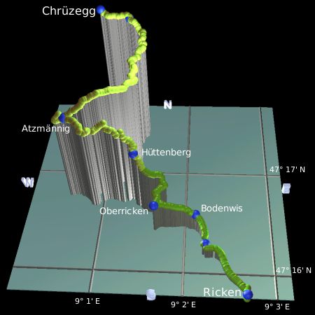 |
The track continues to climb, becoming rather steep on its way up to Hüttenberg. At this restaurant the route becomes a footpath once more, and climbs to become a narrow path through the trees. Crossing a stream, the path curves round to the left, and suddenly reveals a panorama of the Zürichsee and the Glarner Alpen beyond. It continues to curve round, however, and oddly even drops slightly as it comes round towards Atzmännig, making you wonder if this is the right way. Soon you reach the signpost at Atzmännig though, with a crossroads of footpaths and three options for the Toggenburger Höhenweg - head upward for the chairlift station (and a good lookout point with benches to rest on!).
From the chairlift station at Atzmännig you get great views in both directions - over the Zürichsee to the distant Rigi and Pilatus, including the Glärnisch range and towards the Glarus valley, and also forwards along the ridge round to Chrüzegg - the Berggasthaus is visible ahead in a slight dip on the skyline.
Back at the path-crossing, take the right-hand option towards Chrüzegg and enjoy the sweeping panoramas to the right as the path traverses back eastwards. Shortly the path forks, with two possible routes round to Chrüzegg. The upper route climbs to Tweralpspitz, but in case of snow or in case of shooting activities it's advisable to take the lower, flatter route to the left. This says goodbye to the Zürichsee and follows a narrow path through the trees, at one point climbing a steep set of steps alongside a steep pebbley cliff. The path continues more or less on the level, following a gradual leftward curve around the ridge. Säntis and the distant Churfirstens are visible to the right, and the Zürichsee appears again round to the left.
Shortly you arrive at the Berggasthaus Chrüzegg on the right of the path. By the fence is a panorama board showing all of the peaks visible on a clear day. These include Speer, Glärnisch and Tödi, the Mythens, Rigi and Pilatus. Round to the northeast is an expanse of green flatland to the distant German mountains, and you can also see both the Zürichsee and the Bodensee.
The Berggasthaus here has its own website at berggasthaus-chruezegg.ch (German only),
and offers accommodation in various dorms and rooms. The double room for CHF 30 per person is excellent and good value, but breakfast is
extra at a hefty CHF 13.
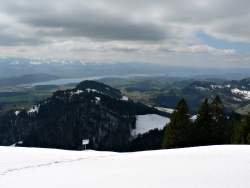
 Rigi and Pilatus in the distance 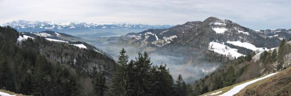 mist-covered valley to the west  Zürcher Oberland 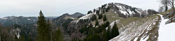 Path traversing towards the Schnebelhorn |
Hike time: | 5 hours |
Approx dist: | 14 km |
Start: | Chrüzegg |
Finish: | Mühlrüti |
Profile: | From 1290m over ridges down to 760m |
Rating: | Medium |
Chrüzegg - Habrüti Sattel - Schindelberg - Schnebelhorn - Hirzegg - Älpli - Hulftegg - Mühlrüti
From the Bergrestaurant at Chrüzegg, the path continues along the ridge and makes a short climb up to a cross at the high point of the day at 1315m. Shortly afterwards the path forks, with the right fork leading down into a silent wood, quite a contrast from the airy panoramas of earlier. The path weaves between the tall trees, losing height, sporadically marked by yellow diamonds on the trees.
Soon you pop out of the wood at Habrüti Sattel, where you get views back along the ridge and down into the misty valley to Schutt (where the chairlift climbs to Atzmännig). Rounding the next right-hand bend gives views northwards into the Zürcher Oberland and its somewhat drab-looking low peaks thinly covered in trees. The end of the Zürichsee is still visible too, along with the snow-capped Glärnisch range and its companions.
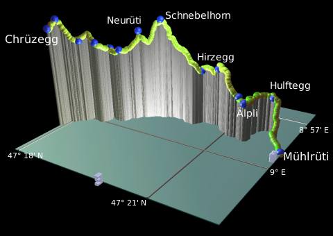 |
The track drops through Chreuel and sweeps round leftwards past the (closed) restaurant at Schindelberg. The steepness of these modest valleys is impressive, if a little gloomy. Beyond Schindelberg a footpath forks right from the main track and heads uphill to a small hut on the pass called Neurüti. From here you get the first proper view of the Schnebelhorn directly ahead.
From Neurüti the track curves around to the base of the Schnebelhorn where a path forks right straight up the hillside. This path zigzags its way steeply up to the summit, a brief foray into the Zürich canton to conquer its highest peak. This is well worth the effort as the panorama from the top is an almost unbroken 360° one with guaranteed cobweb-blowing into the bargain.
Beginning the descent, it's a rooty and sometimes steep drop straight ahead towards Hirzegg. After this fairly sizeable (and quite windy!) descent, there's a short uphill stretch and then around to Rotengübel, followed by a climb over tree roots and steps up to a second path branch. This is where we leave the other Schnebelhorn route and bear right signposted for Mühlrüti.
A further traverse with views this time out to the right-hand side, brings us out to meet a track which, marked with yellow diamonds, drops sharply down to Älpli Süd and on to Älpli. From here the track is almost completely level, winding through the forest past agricultural machinery and wood-stores. The unfamiliar sound of road traffic is the indication that the track is approaching Hulftegg, whose restaurant sits at the pass just a short distance after the track meets the road. This restaurant, and the winding roads around it seem to be a magnet for cyclists and motorcyclists alike, toiling up and cruising down, as well as resting in the sunshine and being seen. There is a bus service here for those who want to cut the walk a little shorter.
For those continuing, follow the road down towards the now-visible village of Mühlrüti below, until a yellow marker on the roadside points right down the field. This path drops swiftly down to shortcut the road, crossing it lower down and making another shortcut. Then it crosses the road for a second time, onto a faintly-marked farm track on the right of the road. This crosses the fields and drops alongside a small stream, looping around the church to the crossroads at Mühlrüti. The post bus stop is just a little further on on the right-hand side.
Buses from Mühlrüti to Bütschwil are not very frequent, but the restaurant Hirschen here just opposite the church makes
a convenient place to wait and get refreshments. It might not look very open but the restaurant is up on the first floor and gives a
friendly welcome.
 Looking back down to Mühlrüti 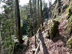 path along steep cliffside 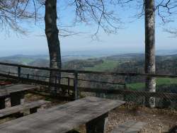 view from St Iddaburg 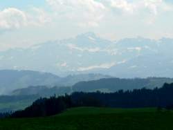 Säntis in the distance 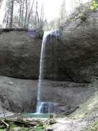 Giessenfall |
Hike time: | 6 hours |
Approx dist: | 20 km |
Start: | Mühlrüti |
Finish: | Wil |
Profile: | From 760m over 970m ridge down to 550m |
Rating: | Medium |
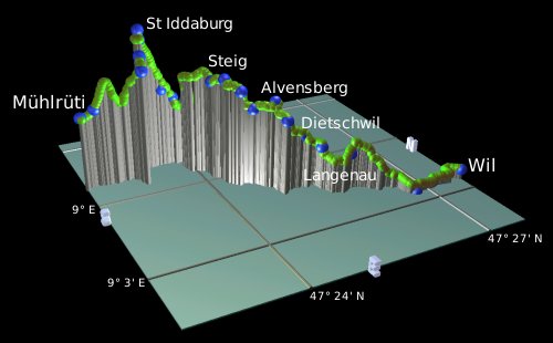
Mühlrüti - St Iddaburg - Steig - Schallenberg - Dietschwil - Giessenfall - Wilen - Wil
From the crossroads in Mühlrüti, follow the signposts across the main road, forking right down past the restaurant Tell. The route then follows farm tracks up the ridge towards the cross, reaching the ridgetop close to a farmhouse.
Follow the path down the other side of the ridge, zigzagging down across the fields and then up to meet the road. Turn right along the road, and then immediately left to climb back up the other side. Säntis starts to reappear into view from behind the ridge behind you as you gain height. The path meets a lane, which continues uphill to Egg, with Säntis pulling the Churfirstens into view behind it.
 |
Continue on the lane uphill from Egg to the left towards St Iddaburg, until the path leaves to the right signposted for the grotto. This narrow path then follows the side of the very steep ridge, separated from the drop by a wooden handrail. Just after a path crossing, you come across the grotto itself, like a small open-air church with an elaborate shrine built into the rock wall. This grotto has quite a special location, between the sheer cliff and the open plain below.
From the path crossing just before the grotto, take the uphill path to reach St Iddaburg itself, with a restaurant, chapel and more of the views out over the plain, from this prominent outcrop. A confirmation of this prominence is provided by the descent - follow the signposts to the left of the chapel and begin the long descent down towards Hüttenstetten. This time there's no handrail, and the roots and loose stones can make it a little awkward. Ignore the right fork marked for the grotto, instead carry on downhill to Hüttenstetten Süd, almost 200m below the summit.
Continue on to Hüttenstetten, and follow the road round and over the stream, climbing through the forest before popping out at Steig with view of Säntis and the Churfirstens over the agricultural landscape. Head across the crossroads, and fork immediately left (faintly marked) uphill towards the trees. Pass Taa, and go through the wooded stretch with views to the northwest, through Alvensberg and out onto a green meadow section. Cross this level, open stretch to Schallenberg and a good lookout point.
Take the track down to the left, heading across the fields to cross the road at Dietschwil. The streamside path starts off rather derelict but improves as you go downstream, eventually joining a logging track to Giessenfall. You can't really get a good impression of this waterfall from above, you need to go down to the base to see it properly. Fortunately, that's exactly what the path does, heading down an elaborate set of steps to the foot of the falls and then continuing downstream.
The track passes Langenau and out into the open - with views of impending urbanity including residential and industrial buildings. The large factory with the square reddish tower is particularly visible, this belongs to Silo AG and gives a reference point for Wil, not far from the rail station.
Head around the football pitch to Vogelherd, and alongside the railway line (the Thurweg) out onto the main road. Turn left
here, and bear right following the small yellow markers leading right to the station. Direct trains leave regularly from here
back to Zürich.
The following are the coordinates for waypoints along this route, obtained from GPS. They can be used either in another GPS, or along with a map, to provide additional references if necessary.
                           Latitude       Longitude    Altitude(m)
        Wildhaus          N 47°12'12.4    E009°21'04.9    1098
        Oberdorf          N 47°11'32.5    E009°20'42.7    1234
        Hägis             N 47°11'23.0    E009°20'21.5    1218
        Dunkelboden       N 47°10'48.0    E009°19'47.7    1243
        Iltios            N 47°11'05.8    E009°18'42.2    1350
        Herrenwald        N 47°10'55.6    E009°18'06.9    1370
        Sellamatt         N 47°10'56.9    E009°17'48.0    1391
        Mittelstof        N 47°10'27.0    E009°17'23.5    1472
        Unterhag          N 47°10'12.9    E009°16'07.0    1590
        Rugg              N 47°10'11.5    E009°15'41.9    1580
        Strichboden       N 47°10'12.6    E009°15'15.2    1628
        Tritt             N 47°09'03.6    E009°12'52.7    1827
        First             N 47°09'08.6    E009°12'33.8    1663
        Looch             N 47°09'08.8    E009°12'04.8    1560
        Egg               N 47°09'02.8    E009°11'44.4    1475
        Arvenbüel         N 47°08'49.9    E009°10'25.9    1279

        Heiggen           N 47°09'11.4    E009°10'40.1    1382
        Altschen          N 47°09'36.2    E009°11'11.4    1388
        Hüttlisboden      N 47°09'53.0    E009°10'35.3    1522
        Schwisolen        N 47°09'48.1    E009°11'13.9    1450
        Furgglen          N 47°10'10.0    E009°10'39.2    1500
        Hinter Höhi       N 47°10'18.3    E009°09'46.6    1410
        Stöcklersitten    N 47°10'31.9    E009°10'28.5    1423
        Vordermatt        N 47°10'33.2    E009°08'21.8    1456
        Oberchäseren      N 47°10'41.3    E009°07'44.0    1649
        Stelli            N 47°10'59.4    E009°07'28.7    1760
        Mült West         N 47°11'10.8    E009°07'47.7    1640
        Schilt            N 47°11'28.0    E009°08'03.9    1600
        Butz              N 47°11'43.9    E009°08'10.7    1500
        Ellisalp          N 47°11'40.0    E009°07'46.9    1465
        Usser Gheist      N 47°11'51.7    E009°06'51.1    1509
        Tanzboden         N 47°13'16.4    E009°06'27.0    1443

        Tschochen         N 47°13'22.8    E009°06'07.9    1380
        Stotzweid         N 47°14'07.4    E009°06'08.3    1197
        Ober Bächen       N 47°14'18.2    E009°05'43.9    1227
        Büertann          N 47°14'43.6    E009°05'11.2    1217
        Cholertoni        N 47°15'06.5    E009°04'11.4    1130
        Stosslegi         N 47°15'22.1    E009°03'31.2     915
        Ricken            N 47°15'48.3    E009°02'40.8     786

        Bodenwis          N 47°16'24.8    E009°02'07.2     850
        Oberricken        N 47°16'23.8    E009°01'39.1     906
        Hüttenberg        N 47°16'39.0    E009°01'25.1    1053
        Atzmännig         N 47°16'45.2    E009°00'40.1    1180
        Chegelboden       N 47°17'49.6    E009°01'15.2    1260
        Chrüzegg          N 47°17'54.1    E009°00'53.0    1277

        Cross             N 47°17'57.4    E009°00'38.3    1315
        Habrüti Sattel    N 47°18'13.4    E009°00'11.9    1200
        Chreuel           N 47°18'39.9    E008°59'35.0    1150
        Schindelberg      N 47°18'54.6    E008°59'37.8    1153
        Neurüti           N 47°19'06.8    E008°59'03.1    1234
        Schnebelhorn      N 47°19'32.1    E008°58'46.9    1292
        Hirzegg           N 47°20'21.9    E008°58'28.9    1050
        Rotengübel        N 47°20'42.3    E008°58'25.5    1070
        Älpli             N 47°21'26.6    E008°58'57.9     960
        Hulftegg          N 47°21'46.2    E008°58'02.1     949
        Mühlrüti          N 47°22'15.3    E008°59'05.8     768

        Egg               N 47°23'08.5    E008°59'29.0     882
        Lämmligarten      N 47°23'11.7    E008°59'09.8     909
        St Iddaburg       N 47°23'17.1    E008°58'45.7     966
        Hüttenstetten     N 47°23'48.7    E008°58'40.2     750
        Steig             N 47°24'09.9    E008°59'44.9     834
        Alvensberg        N 47°24'52.3    E009°00'49.8     800
        Schallenberg      N 47°24'54.4    E009°01'18.4     765
        Dietschwil        N 47°25'15.2    E009°01'06.8     703
        Giessenfall       N 47°25'29.7    E009°01'24.3     670
        Langenau          N 47°25'53.6    E009°01'42.4     650
        Wilen             N 47°27'08.4    E009°02'28.1     552
        Wil               N 47°27'41.8    E009°02'30.5     571
This walk is described briefly (in German) at wandersite.ch. The official page has been finally re-established at sg-wanderwege.ch, including the excellent "Toggenburger Höhenweg Prospekt" as pdf. There used to be a nice panorama map of the first section of the walk (including the Klangweg) at wildhausbahnen.ch, but they've cleverly removed it.
For more information about the "Toggenburger Klangweg" between Sellamatt and Oberdorf, and the musical attractions there, see klangwelt.ch. There is a useful brochure available as pdf, but I presume that link won't work for more than a few weeks before it's reorganised again.
Other ActivityWorkshop adventures in the area include Snowboarding in Oberes Toggenburg, Hiking up Speer, Hiking at the Churfirstens, and Hiking up the Schnebelhorn.